
Grünsberg Devil's Church
| Devil church | ||
|---|---|---|
 Grünsberg Devil's Church |
||
| location | District of Nürnberger Land , Bavaria | |
| Waters | Nameless brook | |
| Mountains | Franconian Alb | |
| Geographical location | 49 ° 22 '31 " N , 11 ° 19' 49" E | |
|
||
| Type | canyon | |
| rock | Rhätsandstein | |
| height | 405 m | |
| particularities | Natural monument , geotope | |

The Teufelskirche is a Rhätsandsteinschlucht east of Grünsberg Castle near Altdorf near Nuremberg .
description
The small but wildly romantic gorge is surrounded by heavily weathered sandstone rock formations. The marked hiking path through the gorge is covered by water from numerous spring outlets. The humid microclimate promotes the growth of ferns and mosses. The brook that flows through the gorge flows into the Schwarzach south of Grünsberg Castle .
At the upper end of the gorge, where coarse-grained and hard sandstones are underlain by softer ones, a small waterfall has arisen.

geology
Over the millennia, the brook has dug itself deep into the layers of the Rhaetian Lias sandstone and the Upper Feuerletten, producing natural rock outcrops. About 200 million years ago, in the transition period between Triassic (Upper Keuper = Rhät) and Jura (Lias), there was a shallow inland sea in Central Franconia in the northwest and the mainland in the southeast. Fine-grained and sandy sediments were deposited in this sea , which later solidified into clay and sandstone. Since it is not possible to clearly distinguish which of the rocks are to be assigned to the Rhaetian and which to the Lias, these are called the Rhaet-Lias transition layers. The brown-gray Rhätsandstein can be found on the upper slopes and the upper reaches of the stream. On the other hand, one can see the Upper Feuerletten made of clay on the lower reaches. Weathering and erosion have also exposed small coal seams that contain fossil plant remains (Rhätkohle). The swellable Feuerletten reinforce the formation of gaps in the overlying sandstones, which are easily isolated from the deep erosion to form individual rock bastions. In the 1990s there was a rock fall that blocked the canyon path. In 2018 there was another, albeit smaller, rock fall.
Mining
At the foot of the rock formations at the waterfall, several tunnels up to 70 meters long testify to attempts to mine brown coal and silver. Already in the years 1525, 1600 and 1720 attempts were made to mine here.
Say
The ravine of the Devil's Church has also given rise to local legends. After one, the gorge was formed when the devil is said to have descended with the knight Jörg von Tann , who was slain from the rock while poaching . Another legend relates to a hares hunt.
Protected area
The area is part of the Natura 2000 network and part of the protected area DE6633371, NSG 'Schwarzach-Durchbruch' and Rhätschluchten near Burgthann .
The gorge is designated by the Bavarian State Office for the Environment as geotope 574G002 and a large natural monument .
tourism
The Devil's Church is a near-tourist destination and is accessible all year round. It can be easily reached on foot from Altdorf or Grünsberg via a hiking trail marked with a white 4 on a green background . It is not advisable to " visit " the former mine tunnels by non-experts.
photos

Signpost to the Teufelskirche

Waterfall in winter 2010
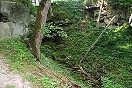
A side valley of the Teufelskirche

Mining tunnel devil's church
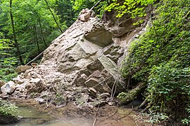
Rock fall 2018


Web links
Individual evidence
- ↑ Note: A Nuremberg file from 1529 mentions miners from a "Perckwerck teuffelskirchen"
- ↑ Sage about the Devil's Church ( Memento of the original from May 29, 2008 in the Internet Archive ) Info: The archive link was inserted automatically and has not yet been checked. Please check the original and archive link according to the instructions and then remove this notice.
- ↑ Natura 2000: DE6633371, NSG 'Schwarzach-Durchbruch' and Rhätschluchten near Burgthann (accessed on June 22, 2013)
- ↑ Geotope: Rhätschlucht "Teufelskirche" northeast of Grünsberg (accessed on March 20, 2020)
- ↑ For the route see Altdorf circular hiking trail no. 4, Teufelskirche (OpenStreetMap)