
Kuhbachtal near Hausen
|
Kuhbachtal near Hausen
|
||
 Kuhbachtal nature reserve |
||
| location | Hausen | |
| surface | 48.8 ha | |
| Identifier | NSG-00502.01 | |
| WDPA ID | 164278 | |
| Geographical location | 49 ° 4 ' N , 11 ° 20' E | |
|
||
| Setup date | November 6, 1995 | |
| administration | District of Roth | |

The Kuhbachtal near Hausen is a nature reserve near Röckenhofen , a district of the Middle Franconian town of Greding in the Roth district in Bavaria . The Kuhbach, a tributary of the Schwarzach, flows through the area .
location
The nature reserve is located in the Altmühltal Nature Park about one kilometer northeast of Hausen and borders on Röckenhofen in the upper area immediately to the west.
description
The Kuhbachtal nature reserve has a total area of 48.8 hectares and was placed under protection in 1995. It bears the cadastral number NSG-00502.01 and is part of the Fauna-Flora-Habitat- Area Trauf of the southern Franconian Jura (FFH-No. 6833-371; WDPA-No. 555521725) and the landscape protection area in the Altmühltal Nature Park (LSG-No. LSG -00565.01; WDPA No. 396115).
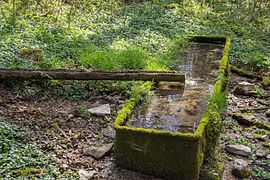
The area is a typical section of the Albtrauf landscape . Geological layers and vegetation of the Jura change here from the valley floor of the Schwarzach up to the edges of the Alb plateau. The Kuhbach flows through the valley and flows into the Schwarzach at Petersmühle . In the middle part of the valley, the brook has also formed some sintered terraces .
Lean lawns and wet areas can be found in the open lower slope . In the bach leaked slope gutter thrive sedge Riede with pronounced Bulten of Carex paniculata , Slim harrow Riede , reed beds and tall herb communities . Rare species such as narrow-leaved cottongrass , butterwort and various types of orchids can also be found here. The stream is also lined with hedges in sections.
The steeper slope in the upper area of the iron sandstone is covered with mixed deciduous forest. The Kuhbach rises from several sources and is accompanied by spring moor areas and a brook, alder and ash forest .
Before the connection to the water supply (1912), the villagers of Röckenhofen supplied themselves with water. When it was very dry in summer, the residents fetched water for humans and animals from the springs here. The water from the Zankel spring was of particularly good quality and was used as drinking water. Cattle and service water was taken from the double-armed Kuhbach spring .
In its further course, steep rock faces give the typical Jura valley a gorge-like character. Above the forest near Röckenricht, along the edge of the Alb plateau, there are extensive, species-rich limestone grasslands over a length of 1.5 kilometers , which are grazed by sheep .
A visit is particularly worthwhile in the spring green of the meadows and in the flowering summer months.
Picture gallery

A source of the Kuhbach stream
The source of quarrels

Stream, sintered
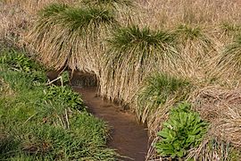
Stream in the lower slope

Limestone grasslands


Individual evidence
- ↑ Location of the Kuhbach valley near Hausen, BayernAtlas (accessed on August 18, 2016)
- ↑ Government Gazette Middle Franconia, ordinance, Kuhbachtal near Hausen (accessed on August 10, 2016)
- ↑ www.regierung.mittelfranken, Kuhbachtal near Hausen (accessed on August 18, 2016)
- ↑ Information board on site, see Commons
Web links
- Location of the NSG "Kuhbachtal bei Hausen" in OpenStreetMap (accessed on August 10, 2016)
