Rasch (Altdorf near Nuremberg)
|
Quickly
City of Altdorf near Nuremberg
|
|
|---|---|
| Coordinates: 49 ° 22 ′ 2 ″ N , 11 ° 22 ′ 44 ″ E | |
| Height : | 381 (374-421) m above sea level NN |
| Residents : | 958 (Jan 2, 2017) |
| Incorporation : | January 1, 1972 |
| Postal code : | 90518 |
| Area code : | 09187 |
|
Quickly
|
|
Rasch is a district of the town of Altdorf near Nuremberg in the district of Nürnberger Land , Middle Franconia , Bavaria .
geography
location
The parish village is located about 2.8 kilometers southeast of Altdorf and is traversed by the Schwarzach , which divides the place into two non-contiguous halves. Neighboring towns clockwise are Altdorf, Schleifmühle , Unterölsbach , Gspannberg , Schwarzenbach and Prackenfels .
Natural allocation
According to the natural spatial classification of Germany (according to Meynen / Schmithüsen et al.), Rasch is part of the natural spatial main unit group Franconian Keuper-Lias-Land , which is part of the south-west German layer level country (according to Ssymank). The Altdorfer Land is located in the main natural space foreland of the central Franconian Alb .
Geology and soils
The Amaltheenton Formation from the Black Jurassic Group (Lias) is geologically shaped. Dark to black-gray clay and clay marl with pyrite and limestone concretions are the dominant rocks, some of which have stored fossils . On top there are Posidonia schist and Jurensis marl formations from the Lias. The layers of the Black Jurassic Group are overlaid by layers of the Brown Jurassic Group (Dogger). The Opalinus Clay Formation, consisting of clays and claystones , emerges on these topographically higher locations . The summit of the Rascher Berg has another geological layer with rocks from the iron sandstone formation . Small iron ore seams are embedded in the fine to medium-grained and iron-shed sandstone of the summit. The floodplain landscape of the Schwarzach is characterized by Quaternary valley fillings.
Almost exclusively Regosol and Pelosol soils from the two soil types loam and clay have developed on the Lia layers . The soil type Pararendzina is predominant on the Great Dane strata. The valley floor of the Schwarzach is covered with the fertile and water- shaped Vega soils from silt to clay ( floodplain sediment).
topography
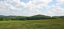
The varied relief of the Rasch landscape is characterized on the one hand by the level and flat locations along the Schwarzach valley and on the other hand the topography of the Lias-Dogger landscape is shaped by the foothills of the Franconian Alb . The Rascher Berg is the highest point at 469 meters. The summit is about 20 meters south of the municipality.
climate
Quickly lies in the cool, temperate climate zone and has a humid climate . The Altdorfer Land is located in the transition area between the humid Atlantic and the dry continental climate . After the climate classification of Köppen / Geiger counts quickly to temperate warm rainy climate (Cfb climate). The mean air temperature of the warmest month remains below 22 ° C and that of the coldest month above -3 ° C. The Lias Dogger landscape warms up faster in spring and autumn than the meadow areas along the Schwarzachtal.
history
Surname
The place name is probably derived from the Raschbach, which flows into the Schwarzach at Schleifmühle.
Early history
The village is one of the oldest places in the Altdorfer Land. A Middle Neolithic stone ax find shows that the area near Rasch was settled as early as the Neolithic Age. Nomadic hunters and gatherers settled down as farmers in the fertile Schwarzach lowlands. North of the river, opposite the old town center is a place of settlement from the Bronze Age (around 2500 v. Chr.) And the Middle Ages . (D-5-6634-0082) During the great migrations have Juthungen settled in this room, their culture by 500 went down. Boirian settlers immigrated from the east into the Schwarzachtal around 650 , but were ousted again around 725 by the Franks advancing from the west .
middle Ages
In the 7th and 8th centuries, a pagan cult site was located on today's church area. In High Rasch one of the most important was by written references from the 12th and early 13th century imperial castles in the king's land south of Nuremberg. It was assumed that the Burgstall was situated on the Rascher Berg, in the Kaar corridor . Traces of fortifications (D-5-6634-0026) on the Rascher Berg support this thesis advocated by the castle researcher Helmut Kunstmann . However, more detailed archaeological investigations have shown that the former castle complex is about one kilometer south in the Oberpfälzer Flur Hofbach . (D-3-6634-0065) Both the structures of the approximately 1.5 hectare section fortification and the (0.5 ha) Castle barn with its ring wall and an almost equally large, south adjacent outer bailey still clearly visible.
Modern times
From 1312 a Harder von Rasch family appears , whose manor may have been based on a castle hat fief from the destroyed Hohenrasch Castle. In 1393 Konrad Harder sold shares to his brother-in-law Hans Strupperger and to Anna Waldstromer. In the early 15th century, Jakob Strupperger, who appeared in 1427 as Albrecht Harder's uncle, took over the small manor from his father. According to Klöhr, a new seat near the church on a former farm is said to have arisen under him at that time, from which the later property No. 27 (since 1819 parsonage) emerged. In 1550, the Nuremberg citizen Andreas Oertel acquired the property, which burned down in the Second Margrave War in 1552.
Together with Grünsberg, the Rasch manor fell in 1578 to the younger Oertel son-in-law Sigmund Haller von Hallerstein (1530–1589), who rounded off the property complex by purchasing further goods in Rasch and Prackenfels. After the death of his son of the same name in 1620, the "Burgstall" Rasch and the associated goods were sold to grandson Johann Andreas Haller for 2,100 guilders in 1646, who sold them to the imperial city of Nuremberg for 4,500 guilders in 1651 with the now restored seat. This leased the property to the Pömer family. Felix Welser (from the Augsburg line) followed in 1678 by purchase , followed by the Volckamer von Kirchensittenbach family in 1756 , who lost the property in 1813 through demolition and foreclosure auction. The former manor house has been a rectory since 1819.
With the community edict of 1808, Rasch became a politically independent community. The Bavarian original cadastre shows the place in the 1810s as a church village with 49 hearths, the church and the associated church .
The water power of the Schwarzach, then called Warzach , drove two mill wheels. Only the street names Am Mühlberg and the district road LAU 29 , which is called Schleifmühlstraße there , still remind of the historical use of hydropower. While the Schwarzach was still meandering freely in the meadow north of the village , it was regulated by a weir above the mill .
- Ludwig-Danube-Main Canal
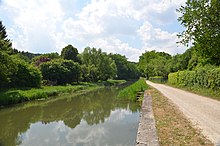
The Ludwig-Danube-Main Canal , built from 1835 to 1846, passed by Rasch and there were two loading points (landing stages) there for cargo handling . These mainly served a brick factory as a factory site, as well as for the export of agricultural products and the import of coal. In 1950 the Ludwig Canal was closed again, the landing stages have passed, but there has been an occasional museum operation with the towing ship Elfriede in the summer months .
As part of the regional reform in Bavaria , Rasch was incorporated into Altdorf on January 1, 1972.
Population development
| year | 1910 | 1933 | 1939 | 1987 | 2013 | 2016 |
|---|---|---|---|---|---|---|
| population | 438 | 433 | 387 | 712 | 870 | 958 |
Culture and sights
- Parish Church of St. Michael
The evangelical parish church of St. Michael is well worth seeing in Rasch. It is the mother church of Altdorf and its history goes back to the 11th century. The church in Hagenhausen, which was consecrated by Bishop Gundekar II in the 12th century, was probably the mother parish of the Rasch ministerial seat. The church of St. Michael is provided with Romanesque round arch friezes on the outer walls. The conversion to a fortified church with moat, wall and gate tower probably took place in the 14th century. The winged altar from the circle of Michael Wolgemut dates from the 15th century, on this four saints can be seen with their classic identifying marks: Catherine with sword and broken wheel, Barbara with chalice and host, Magdalena with ointment box and Margaret with a little dragon. In 2011 the church was renovated.
- Shepherd's Chapel
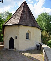
Immediately next to the church is a chapel, the so-called shepherd's chapel, which is now used as a funeral hall . The north-south orientation of the building and three runes attached to the outer walls are signs of a Germanic place of worship.
The three characters and symbols shown above the window show a pictorial raven, which stands for Wodan, an Othala rune (ᛟ) and a Gebo rune ( ᚷ ) . The pagan temple was used to worship the highest Germanic god Wodan ( Odin ). The chapel is unique for southern Germany. Only a few comparable relics are known from the area of the left Lower Rhine . The shepherd's chapel functioned as a place of consecration and offerings were also made here. In the 8th century - at the time of the Franconian apostle Willibald von Eichstätt - the Altdorfer Land was Christianized and missionaries spread the Christian faith from the chapel used as a baptistery to the surrounding area. Today a Romanesque font indicates the full-body baptisms that were carried out.
A late medieval atonement cross on the A3 .
In Rasch there are a few other buildings that are listed as architectural monuments . In the immediate vicinity are the Ludwig-Danube-Main Canal, some remarkable Räthschluchten , the Teufelshöhle and the Löwengrube .
See also: List of architectural monuments in Rasch
traffic
- The 2401 state road is quickly crossed. The A3 motorway runs around 700 meters north of the town center, and the next junctions are around three kilometers away as the crow flies.
- The local public transport serves Rasch at four stops with the VGN bus line 512, which connects to the Nuremberg S-Bahn network in Altdorf and to the Nuremberg – Regensburg railway line in Neumarkt . The N 55 night bus also runs on the weekends .
Sons and daughters
- Wolfgang Haffner (* 1965), drummer, grew up in Rasch
literature
- Nuremberg country . Karl Pfeiffer's Buchdruckerei und Verlag, Hersbruck 1993, ISBN 3-9800386-5-3 .
Web links
- Quickly on the website of the city of Altdorf
- Quickly in the location database of the Bavarian State Library Online . Bavarian State Library
Individual evidence
- ↑ a b City of Altdorf b. Nuremberg, population statistics 2016 (accessed on November 3, 2017)
- ↑ Location of the district in the Bavaria Atlas (accessed on November 3, 2017).
- ↑ Map of the main natural space units and natural space units in Bavaria. Bavarian State Office for the Environment, accessed on May 27, 2018 .
- ↑ UmweltAtlas Bayern: digital geological map of Bavaria 1: 25,000 (dGK25). Bavarian State Office for the Environment, accessed on May 23, 2018 .
- ↑ UmweltAtlas Bayern: Overview soil map 1: 25,000 (ÜBK25). Bavarian State Office for the Environment, accessed on May 23, 2018 .
- ^ BayernAtlas. State Office for Digitization, Broadband and Surveying, accessed on May 27, 2018 .
- ↑ Climate. Climate-Data.org, accessed May 30, 2018 .
- ↑ a b Quickly. City of Altdorf, accessed on May 21, 2018 .
- ↑ a b c d e f g h Michaela Moritz: Nürnberger Land . Ed .: House of Bavarian History of the Bavarian State Ministry for Education and Culture, Science and Art. No. 11 . Verlag Friedrich Pustet, Regensburg 2014, ISBN 978-3-7917-2637-3 , p. 42 .
- ↑ a b Eckhardt Pfeiffer (Ed.): Nürnberger Land . Karl Pfeiffer's Buchdruckerei und Verlag, Hersbruck 1989, ISBN 3-9800386-5-3 , p. 61, 80 .
- ↑ List of monuments: Administrative region Middle Franconia, Nuremberg region, Altdorf near Nuremberg. Bavarian State Office for Monument Preservation, February 9, 2018, accessed on May 21, 2018 .
- ^ History of Altdorf. City of Altdorf, 2012, accessed on May 23, 2018 .
- ↑ LfD list for Berg id Opf. (.Pdf)
- ↑ Robert Giersch, Andreas Schlunk, Berthold Frhr. von Haller: Castles and mansions in the Nuremberg countryside . Ed .: Altnürnberger Landschaft eV Self-published by the Altnürnberger Landschaft eV, Lauf an der Pegnitz 2006, ISBN 978-3-00-020677-1 , p. 336 f .
- ↑ Section fortification in the relief display at BayernAtlas Klassik
- ↑ Burgstall in the relief display at BayernAtlas Klassik
- ↑ Quickly to BayernAtlas Klassik
- ^ Grinding mill Rasch on BayernAtlas Klassik
- ^ Wilhelm Volkert (ed.): Handbook of Bavarian offices, communities and courts 1799–1980 . CH Beck, Munich 1983, ISBN 3-406-09669-7 , p. 542 .
- ^ Community directory , District Office Nuremberg
- ^ A b Michael Rademacher: German administrative history from the unification of the empire in 1871 to the reunification in 1990. City and district of Nuremberg. (Online material for the dissertation, Osnabrück 2006).
- ^ Association for Computer Genealogy e. V. ( Page no longer available , search in web archives ) Info: The link was automatically marked as defective. Please check the link according to the instructions and then remove this notice. , Quickly
- ↑ Frankenalb, Information St. Michael in Rasch ( page no longer available , search in web archives ) Info: The link was automatically marked as defective. Please check the link according to the instructions and then remove this notice. (Accessed March 16, 2013)
- ↑ a b Alex Blinten: Schäferkapelle was a pre-Christian place of worship. Der Bote, January 17, 2014, accessed on May 21, 2018 .
- ↑ VGN bus line 512 (.pdf) ( Memento of the original from May 28, 2018 in the Internet Archive ) Info: The archive link was automatically inserted and not yet checked. Please check the original and archive link according to the instructions and then remove this notice.


