
Natural space
In physical geography , natural space is understood to be a unit of geographical space characterized by parameters of the geofactors climate , relief , water balance , soil , geological structure and biosphere . The very similar geographical concept of landscape is used partly with the same meaning, partly also differentiating, in that “natural space” describes only the natural law-determined components of the respective spatial section, while “landscape” includes other components such as the current land use.
The individual natural spaces can either be designed as spatial individuals whose overall character differs from the neighboring area units in individual or several geofactors, or as types that have a similar combination of features. In both cases, landscape units of a certain appearance and location characteristics as well as location quality are separated from neighboring areas with distinguishable characteristics.
Natural structure
As a rule, natural spaces are not determined and delimited individually, but rather across the board for more or less extensive sections of the landscape . Depending on the selection and combination of the considered geofactors, units of different sizes result, which can be arranged in hierarchical structures. Natural areas on the same level should be determined by the same parameters. A change in the rank level, i.e. to hierarchically higher or lower-level units, is always accompanied by a corresponding change in the characterizing features.
The number of hierarchical levels shown is variable, as are their names. In general, landscape research differentiates between the scale ranges or dimension levels topical , choral , regional and planetary . The lowest, topical dimension is made up of homogeneous, i.e. H. Basic units ( physiotopes , ecotopes ) that cannot be divided up further . The choral dimension means associations or mosaics of basic units in an area that corresponds roughly to the colloquial term of “landscapes”, that is, for humans mostly still manageable in nature. The line between choral and regional dimensions is not sharply drawn. The planetary or global dimension is the uppermost, its object the entire surface of the earth.
Regional historians, geographers, biologists and others concerned with spatial structures have been discussing the question of appropriate structuring or natural spatial structure since the middle of the 19th century. Two approaches are currently established. The older one is a division in the literal sense of the word, so one starts with large units and subdivides into smaller and smaller units based on differentiating characteristics. The more recent method of so-called natural spatial order , on the other hand, begins with a complete recording of the smallest basic units and then aggregates to ever larger units based on common or superordinate characteristics.
The mapping and classification of natural areas is often application-oriented, i.e. it is aimed at specific purposes; the one planned in each case determines the area covered and its main focus. Therefore, there can be several different classifications for a certain territory and adjacent territorial classifications can be incompatible - this becomes conspicuous, for example, when adjacent map sheets name or subdivide an area above their border differently.
Global dimension
The landforms or physiographic regions of the earth - their natural spatial units - are mainly subdivided in the Anglo-American literature according to Nevin Fenneman (1916). In German geography, which partly differs from this approach based almost purely on geomorphology , or the combination of geological conditions and topography, Ernst Neef , among others, brought this overview closer.
The rough division takes place in continents, whereby there are connections between the individual continental blocks because of a common past or a similar genesis. Below the continents as the highest classification criterion, divisions, provinces and sections follow in this scheme , according to the nomenclature of the USGS .
Regional and choral dimension
Germany

Apart from the amalgamation of some old groups, the boundaries of the main unit groups still correspond to the mapping of 1960 in the Handbook of Natural Spatial Structure of Germany and are therefore marginally incompatible with the major regions of the 1st and 2nd order, which were only identified later.
The manual of the natural structure of Germany with its updates has been the most common structure model in Germany since the 1950s. It serves as a basis for planning and observation in most federal states and is also used in a slightly modified form for phenological studies, for example by the German Meteorological Service . The structure is hierarchically divided into seven levels.
The land area of Germany is part of five high-level units designated as natural spatial regions of the first order . According to the current status, the subdivision of these units results in the following natural spatial large regions of the 2nd order (prefixed arrow "→"):
-
North German Lowlands
- → Marshland (61, 67, 68)
- → Mecklenburg-Western Pomerania coastal area (71)
- → North (east) German lake district
(70, 72–75, N v. 80) - → North German heath, Geest, hill and flat country
(58–60, 62–64, 69, 76–89 without N v. 80) - → Lössbörden
(44 without S, 45–46, 50–52, parts of 58 and 62)
-
Low mountain range threshold
- → Rhenish slate mountains (basement crags; 24–25, 27–33, 56)
- → Lower Saxony-Hessian mountainous region (Bruchschollentafelland)
- Lower Saxony highlands (36–37, 53)
- West and East Hessian mountains (34–35)
- → Harz (basement floodplain; 38)
- → Thuringian Basin (with edge plates) (layer level land; 47–48)
- → Eastern low mountain range threshold
- Thuringian-Franconian Central Mountains (39) / Vogtland (41)
- Ore Mountains (42)
- Western Sudetes (43, S v. 44)
- Upper Palatinate-Bavarian Forest (40)
- Layer level land on both sides of the Upper Rhine Rift
- → Northern French layered level country (17–19, 26)
- → Upper Rhine lowlands (20–23)
- → Southwest German stepland (08–16)
- → Upper Palatinate-Upper Main Hill Country (07)
-
Alpine foothills
- → Northern Alpine Foreland (04-06)
- → Pre-Alpine hills and moorland (03)
-
Alps
- → Swabian-Bavarian Prealps (02)
- → Northern Limestone Alps (01)
Otto Klausing describes the second level of the natural spatial units as a region .
Large third-order natural regions generally correspond to the main unit groups , unless these already represent large-scale second-order regions (e.g. Harz and Upper Rhine Rifts). However, third-order units that took up a lot of space were often divided into two or more groups, in the shift-level country for example the Swabian-Franconian Gaue (12/13), Keuper-Lias countries (10/11) and albums (08/09) - in the present case also from cultural-spatial aspects. The Rhenish Slate Mountains represent, in spite of their division into at least 8 main unit groups, a unit of the second and third order.
The further subdivisions - choral dimension:
- 4th order : main unit (three-digit code)
- 5th order : subunit (three-digit code with one decimal place)
- 6th order : subunit (three-digit code with two decimal places)
topical dimension (hardly worked out yet):
- 7th order : basic unit ("tile"; three-digit code with three decimal places)
- Singularity / single form ("tile"; mostly without code number)
Alternative classifications are being developed and used in individual federal states. The system of natural spaces in Saxony is consistently based on the principle of natural spatial order (from bottom to top). The natural areas of Thuringia are abstracted into types on a choral level and are therefore not easily compatible with the structures of the neighboring territories, which are based on natural spatial individuals .
Lists by federal state:
- Baden-Württemberg
- Hesse
- North Rhine-Westphalia
- Rhineland-Palatinate
- Saarland
- Saxony
- Schleswig-Holstein
The Federal Agency for Nature Conservation uses a variant of this structure that has only been slightly modified under biogeographical aspects as the planning basis for the European Natura 2000 system of protected areas . The forest-ecological natural area classification of Germany shows clearer deviations according to the special focus .
Austria
Traditional scientific structure:
- Foreland and rim-alpine basins:
- Gneiss and granite highlands
- Austrian Alps
- Northern Alps
- Central Alps
- Southern Alps (although the Austrian part of this mountain range is quite small)
Switzerland
In Switzerland, the geographical breakdown is historically divided into three parts:
- law
- Mittelland
- Alps (→ Swiss Alps )
The biogeographical regions of Switzerland:
- Jura and beetroot
- Eastern Central Plateau
- Western Central Plateau
- High Rhine and Lake Geneva Region (Région lémanique)
- Prealps
- Northern Alps
- Eastern Central Alps
- Western Central Alps
- Southern alps
- Southern Ticino
The allocation takes place at the municipality level. Since this is a breakdown for statistical purposes, no finer breakdown has been made.
literature
- Institute for applied geodesy (Ed.): Landscapes (names and delimitations). Frankfurt / Main 1979.
Web links
- The cultural landscape and its inventory - definitions and overview of the landscape and natural space mapping in the past and present, at home and abroad, with examples and maps (PDF 5.43 MB, accessed on July 29, 2012)
Individual evidence
- ^ Physiographic divisions of the conterminous US . US Geological Survey. Retrieved December 6, 2007.
- ^ Physiographic & Landform - World, US . Indiana University of Pennsylvania. Archived from the original on October 12, 2007. Info: The archive link was inserted automatically and has not yet been checked. Please check the original and archive link according to the instructions and then remove this notice. Retrieved December 7, 2007.
- ^ The Atlas of Canada - Physiographic Regions . Retrieved December 7, 2007.
- ↑ Defining Physiographic Realms and Regions: The Spatial Variation of Landscapes . Oxford University Press. Retrieved December 7, 2007.
- ↑ Ernst Neef: The face of the earth . Brockhaus GDR 1956
- ↑ Until 1979 the Institute for Regional Studies was divided into four major regions of the first order.
- ^ Emil Meynen (Ed.): Handbook of the natural spatial structure of Germany . Self-published by the Federal Institute for Regional Studies, Remagen / Bad Godesberg 1953–1962
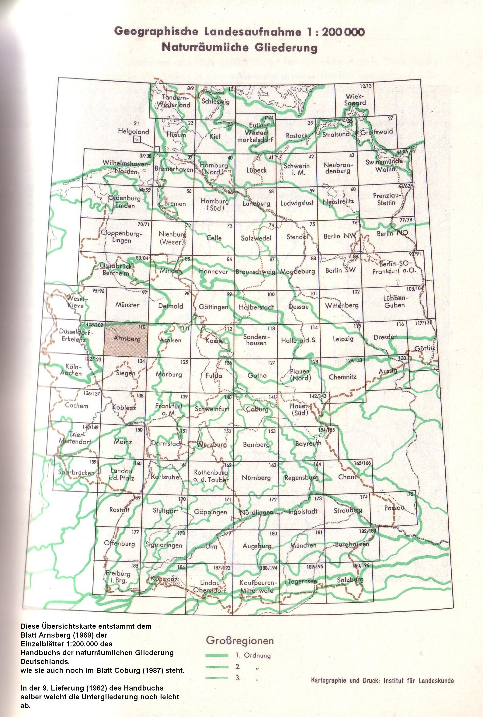
- ↑ The demarcation of the major regions of the 1st and 2nd order comes mainly from the overviews attached to the individual sheets ( here the one from Blatt Arnsberg 1968 , the demarcation on sheet Coburg from 1987 is identical), in Saxony demarcation to natural areas in Saxony ; Overview with main unit groups .
- ↑ a b c d e f g Exact name of the Greater Region 2nd order not known or not assigned.
- ↑ The common term Mittelgebirgsschwelle summarizes the younger Bruchschollentafellländer and the older basement clod lands between the Rhenish Slate Mountains and the Bohemian Massif. The former form a simply contiguous low mountain range, while the basement plaice lands are divided into 3 segments, the smallest and north-central of which is the Harz.
- ↑ In the main unit group West Hessian Uplands, the Kellerwald is not part of the Bruchschollentafelland, but as the western foothills of the Rhenish Slate Mountains, it is part of the Basement Shollenland.
- ↑ On the systematic classification of natural areas - The natural areas of Hesse (Otto Klausing 1974/1988), reprinted in the Environmental Atlas of Hesse
- ↑ Jürg Früh: Geography of Switzerland. The individual landscapes of Switzerland. Volume III (1938).
- ^ René Ch. Schilter: Attempt to structure and typology of the landscape in Switzerland. Zurich 1977.
- ↑ Yves Gonseth, Thomas Wohlgemuth, Bertrand Sansonnens, Alexandre Buttler: The biogeographical regions of Switzerland , UM-137-D, FOEN (2001)