Oberwellitzleithen
|
Oberwellitzleithen
City of Altdorf near Nuremberg
Coordinates: 49 ° 24 ′ 16 ″ N , 11 ° 21 ′ 38 ″ E
|
|
|---|---|
| Height : | 440 (427-449) m above sea level NN |
| Residents : | 95 (Jan. 2, 2017) |
| Incorporation : | January 1, 1978 |
| Postal code : | 90518 |
| Area code : | 09187 |
|
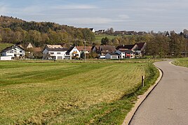
Town view from the south
|
|
Oberwellitzleithen is a district of the town of Altdorf near Nuremberg in the district of Nürnberger Land , Middle Franconia .
Geographical location
The village is at the foot of the Hegenberg and west of Unterwellitzleithen . In the north are the places Ernhofen , Hegnenberg and Pühlheim . In the south lies the city of Altdorf. All around are fields, meadows and forests as well as the A6, on which an industrial and commercial park was built.
etymology
Change of the place name in the course of history: Wylatzleyten, Wilandesleiten, Wylandesleiten, Wielandsleiten, Wellizleiten, Willizleiten, Welletsleiten, Welizleuthen, Welitzleuten, Wellitzleuten, Willizleithen
The place name is combined with the prefix Ober- or Obern-. The ending of the place name refers to the topographical peculiarity of a hillside location (Leithe = slope).
history
Albrecht the Handsome from the House of Hohenzollern and Burgrave of Nuremberg bought the Altdorf Care Office together with the hamlet from his nephew Johann von Nassau . The deed of sale dated June 27, 1360 is the oldest surviving historical document about the place. From 1504 to 1806 it belonged to the territory of the Free Imperial City of Nuremberg. In August 1632 Croatians , who served as mercenaries on the side of the Catholic League under General Tilly during the Thirty Years' War , approached from Wellitz people from Altdorf, but did not take the city.
With the community edict (1808) Oberwellitzleithen belonged to the politically independent community Röthenbach . On January 1, 1978, this was incorporated into Altdorf as part of the Bavarian regional reform .
Population development
| year | 1987 | 2013 | 2016 | 2017 |
|---|---|---|---|---|
| population | 87 | 86 | 95 | 108 |
Architectural monuments
See: Monuments in Oberwellitzleithen
traffic
Federal motorway 6 runs very close to the south . The place can be reached from the district road LAU 24 through a connecting road.
literature
- Nuremberg country . Karl Pfeiffer's Buchdruckerei und Verlag, Hersbruck 1993, ISBN 3-9800386-5-3 .
- Georg Andreas Will; with addenda by Christian Conrad Nopitsch: History and description of the Nuremberg University of Altdorf, 1801, reprint: Scientia Verlag, Aalen 1975.
- Society for family research in Franconia (ed.): Reichsstadt Nürnberg, Altdorf and Hersbruck - Genealogica, Heraldica, Juridica . Nuremberg: Verlag Die Egge in Komm., 1954, 253 p .; IDN: 453615252 (Free series of publications of the Society for Family Research in Franconia; Vol. 6)
- Konrad Lengenfelder: Altdorf near Nuremberg in old views , 5th edition, new edition. of the original edition from 1977. Zaltbommel / Netherlands: Europ. Library, 1995, ISBN 90-288-1515-5 .
- Hans Recknagel : Stories and History. Historical sketches from Altdorf and Nuremberg . Hessel-Verlag, Feucht 2003, ISBN 3-9807345-2-8 .
- Johann Wolfgang Woerlein: The Houbirg or history of Nuremberg Switzerland - Hersbruck, Altdorf and Lauf with their surroundings in the context of world history . Nuremberg 1838.
Web links
- List of monuments for Altdorf near Nuremberg (PDF) at the Bavarian State Office for Monument Preservation
- Oberwellitzleiten on the website of the city of Altdorf
- especially pp. 171-175.
- Oberwellitzleithen in the local database of the Bayerische Landesbibliothek Online . Bavarian State Library
Individual evidence
- ↑ a b City of Altdorf b. Nuremberg, population statistics 2016 (accessed on November 3, 2017)
- ↑ Location of the district in the Bavaria Atlas (accessed on November 3, 2017).
- ^ Association for Computer Genealogy e. V. ( Page no longer available , search in web archives ) Info: The link was automatically marked as defective. Please check the link according to the instructions and then remove this notice. , Oberwellitzleithen

