
Prethalmühle
|
Prethalmühle
City of Altdorf
Coordinates: 49 ° 22 ′ 19 ″ N , 11 ° 20 ′ 59 ″ E
|
|
|---|---|
| Height : | 379 m above sea level NN |
| Residents : | 26 (2012) |
| Postal code : | 90518 |
| Area code : | 09187 |
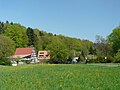
 Prethalmühle, town view
|
|
Prethalmühle is a district of the town of Altdorf near Nuremberg in the district of Nürnberger Land , Middle Franconia , Bavaria .
Geographical location
The hamlet of Prethalmühle is located about 1.8 kilometers south of Altdorf directly on the Schwarzach and borders directly on Prackenfels . It can be reached by road from Altdorf. Opposite the mill is a former guest house from 1643. The house, which is worth seeing, is a monument and is listed as DD-5-74-112-181 .
history
The Prethalmühle has its origins in a high medieval imperial estate and was first mentioned in a document in 1360 . It was destroyed in the Thirty Years War in 1635. The current residential building dates from 1643. For centuries the mill was used to grind flour , but it was also used as a sawmill .
In the course of industrialization , it was converted to produce electricity for the energy-intensive operation of a copper foil factory. Until well into the middle of the 20th century, it supplied the nearby town of Prackenfels with direct current. Today the ecologically generated electricity is fed directly into the grid.
In 2008 the former Gasthaus der Mühle was one of the seven objects in the district of Nürnberger Land that received an award when the district of Middle Franconia was awarded a monument at the time .
Worth seeing in nature
- The Räthschlucht Paffental with the Teufelshöhle
- The lions den
- The river Schwarzach

Prethalmühle
Prethalmühle town view

Prethalmühle, window with coat of arms

Former inn

Rock cellar


literature
- Nuremberg country . Karl Pfeiffer's Buchdruckerei und Verlag, Hersbruck 1993, ISBN 3-9800386-5-3 , p. 322.
Web links
- Prethalmühle. on the website of the city of Altdorf, accessed on July 30, 2012.
- www.Prethalmühle.eu
Individual evidence

Adelheim | Altdorf near Nuremberg | Au | Eismannsberg | Fall House | Grünsberg | Hagenhausen | Hegnenberg | Lochmannshof | Ludersheim | Oberrieden | Oberwellitzleithen | Prackenfels | Prethalmühle | Pühlheim | Quickly | Raschbach | Röthenbach near Altdorf | Grinding mill | Stürzelhof | Dissatisfied | Unterwellitzleithen | Wappeltshofen | Weinhof | Brick hut