
Ross Valley
| coat of arms | Germany map | |
|---|---|---|

|
Coordinates: 49 ° 24 ' N , 10 ° 53' E |
|
| Basic data | ||
| State : | Bavaria | |
| Administrative region : | Middle Franconia | |
| County : | Fuerth | |
| Height : | 373 m above sea level NHN | |
| Area : | 44.38 km 2 | |
| Residents: | 10,010 (Dec. 31, 2019) | |
| Population density : | 226 inhabitants per km 2 | |
| Postal code : | 90574 | |
| Area code : | 09127 | |
| License plate : | FÜ | |
| Community key : | 09 5 73 125 | |
| Market structure: | 17 parts of the community | |
Market administration address : |
Marktplatz 1 90574 Roßtal |
|
| Website : | ||
| Mayor : | Rainer opponent ( SPD ) | |
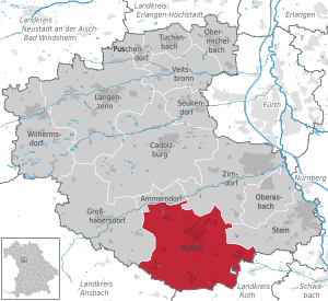
| Location of the Roßtal market in the Fürth district | ||
  |
||


Roßtal (colloquially: "Roschd ə l") is a market in the Middle Franconian district of Fürth .
geography
Geographical location
The Roßtal market is located around 15 kilometers west of Nuremberg . On the northern edge, the Bibert flows through the municipality.
The flat, undulating Keuper landscape of the municipality is located in the natural spatial unit of the Franconian Keuper-Lias-Land and the natural space unit of the Middle Franconian Basin .
Parish parts
The municipality has 17 officially named municipal parts (the type of settlement is given in brackets ):
|
|
|
Neighboring communities
The neighboring communities are:
(List: starting in the north and clockwise)
geology
Rocks from the Middle Keuper , a Triassic formation, can be found in the Roßtal market . Deposits of the bubble sandstone and the Coburg sandstone from the Hassberge Formation predominantly occur. In the south of the municipality, the geological unit of the Lower Burgsandstein of the Löwenstein Formation dominates . Quaternary valley fillings with loose sediments occur in the stream valleys of the Mühlbach and the Bibert.
climate
With its humid climate , the Roßtal market is located in the cool, temperate climate zone . The community is located in the transition area between the humid Atlantic and dry continental climates . According to the Köppen-Geiger climate classification, Franconia, including Roßtal, belongs to the warm, temperate rainy climate (CFB). The mean air temperature of the warmest month remains below 22 ° C and that of the coldest month above -3 ° C.
The average annual rainfall is 679 mm, with an overweight in summer. June is the wettest month with 81 mm. The wettest month is February with 41 mm. The mean temperature over the entire year is 8.5 ° C. From a climatological point of view, July is the warmest month of the year with an average of 17.9 ° C. The lowest temperatures are recorded in January with an average of -0.9 ° C.
history
The place was first mentioned in 953 as "Rossadal". The place name is derived from a field name of the same name, the defining word of which is the Old High German "ros, hros" (= horse) and therefore means "valley of horses". The place name can also be interpreted as a "place of horse breeding". According to the German dictionary (DWB, Der Grimm), Rossstall refers to the place where the horse boys and other lower servants stay and sleep, as well as an unsightly place.
- 954: Mention of Rossal by Widukind as "Horsadal"
- 1050: The place name "Rossestal" appears in a Bamberg document from 1050.
- 1281: The burgraves of Nuremberg bought their first goods in Roßtal.
- 12th and 13th centuries: The place name "Rostal" is written.
- 1328: "Rostal" receives city and market rights from Emperor Ludwig the Bavarian .
- after 1328: The suffix "-stal" later becomes "-stall": "Roßstall".
- 1355: Emperor Charles IV confirmed the granting of town charter.
Towards the end of the 18th century there were 110 properties in Roßtal. The high court and the village and community rulership exercised the Brandenburg-Ansbach judge office Roßtal . The landlords were the Cadolzburg caste office (castle, Fronveste, two taverns, five parish houses, two blacksmiths, nine courtyards, three courtyards, two estates, six estates, one mill, 60 houses), the Roßtal church (rectory, school, sacristan's house, eight houses ) and Nuremberg owners: von Kreß (four houses), von Volckamer (one half-yard), von Welser (two houses).
In 1808, as part of the municipal edict, the Roßtal tax district was formed. In 1810 the municipality of Roßtal was founded, which was congruent with the tax district. She was in administration and jurisdiction of the district court Cadolzburg and in the financial administration of the bursary Cadolzburg (in 1920 the tax office Cadolzburg renamed). In 1818 Roßtal became a market with Magistrate III. Class appointed. From 1862 Roßtal was administered by the Fürth district office (renamed the Fürth district in 1938 ). Jurisdiction remained with the Cadolzburg District Court until 1879, from 1880 to March 1, 1931 it was with the Cadolzburg District Court , since then it has been exercised by the Fürth District Court . The financial management was taken over on January 1, 1929 by the Fürth tax office .
In 1872 the Nuremberg-Ansbach railway line went into operation, at which Roßstall had a train station. There has been electricity in the village since 1910. The transformer station was on the community meadow at Mühlbach.
In 1913 the community "Roßstall" was officially renamed "Roßtal".
In 1961 the municipality had an area of 7.785 km².
Incorporations
On May 1, 1978, the previously independent municipalities of Buchschwabach, Großweismannsdorf and Weitersdorf and parts of the dissolved municipality of Weinzierlein were incorporated.
Population development
Roßal community
| year | 1987 | 2007 | 2008 | 2009 | 2010 | 2011 | 2012 | 2013 | 2014 | 2015 | 2016 | 2017 |
|---|---|---|---|---|---|---|---|---|---|---|---|---|
| Residents | 8006 | 9896 | 9870 | 9806 | 9764 | 9730 | 9658 | 9588 | 9603 | 9612 | 9668 | 9699 |
| Houses | 2092 | 2824 | 2833 | 2854 | 2871 | 2887 | ||||||
| source |
Municipality part of Roßtal (= community Roßtal up to the regional reform)
| year | 1818 | 1840 | 1852 | 1861 | 1867 | 1871 | 1875 | 1880 | 1885 | 1890 | 1895 | 1900 | 1905 | 1910 | 1919 | 1925 | 1933 | 1939 | 1946 | 1950 | 1961 | 1970 | 1987 | 1997 | 2007 | 2018 |
|---|---|---|---|---|---|---|---|---|---|---|---|---|---|---|---|---|---|---|---|---|---|---|---|---|---|---|
| Residents | 724 | 951 | 938 | 940 | 959 | 965 | 1034 | 1059 | 995 | 1017 | 1025 | 1062 | 1169 | 1301 | 1323 | 1447 | 1805 | 2031 | 2669 | 2885 | 3492 | 4098 | 4560 | 5601 * | 5797 * | 5637 * |
| Houses | 121 | 159 | 196 | 178 | 193 | 232 | 406 | 638 | 1195 | |||||||||||||||||
| source |
politics
Market council
The municipal council has 21 members including the mayor.
The individual results for the municipal council election on March 15, 2020 are:
CSU: 30.45%, SPD: 26.00%, FW / FWR (Free Voters Roßtal): 22.24%, Greens: 13.59%, ÖPD: 4.81%, Left: 2.91%.
| CSU | SPD | FW | Green | ÖPD | The left | total | |
|---|---|---|---|---|---|---|---|
| 2014 | 6th | 7th | 5 | 2 | 0 | 0 | 20 seats |
| 2020 | 6th | 5 | 4th | 3 | 1 | 1 | 20 seats |
mayor
Johann Völkl (SPD) (* 1955) was the mayor from May 2008 to April 2020, he was confirmed in office in March 2014 with 74.3% of the votes.
On March 29, 2020, Rainer opponent (SPD) was able to prevail against the CSU candidate Renate Krach in a runoff election as the new mayor of Roßtal.
badges and flags
Rossal has had a coat of arms since the 15th century.
|
|
Blazon : "In gold, a red Gothic church with roof turrets, from whose gate a silver steed strides."
White-red-yellow municipal flag |
| Crest Reason: The coat of arms is speaking for the place name, which was interpreted as Rossstall. It means 'place of breeding horses'. |
Partner municipalities
-
 Auzances , France
Since 1997 there has been a partnership with Auzances, which is supported by the Franco-German Friendship Circle. Due to the good relations between the two partner municipalities, on April 6, 2000 the Roßtal market was awarded the European diploma for the year 2000. On November 8, 2002, the Roßtal market was presented with the Council of Europe's flag of honor . -
 Thalheim / Erzgeb. (Partnership since 1992)
 -
 There are friendly relations with Frankenmuth in the USA, as many Frankenmuth settlers come from Roßtal.
traffic
Road traffic
Bundesstraße 14 runs through the districts of Großweismannsdorf and Buchschwabach in the south of Markt Roßtal . The state road 2409 runs north to Weinzierlein or southeast to B 14. The county road FÜ 22 runs southwest to Clarsbach or northwest over Weitersdorf after Anwanden . The FÜ 15 runs northwest to Buttendorf . A community road runs north to Stöckach , two other community roads run south to Trettendorf and Wimpashof .
railroad

The train stations and stops Roßtal-Bahnhof , Roßtal-Wegbrücke and Raitersaich are located along the route within the municipality . The Roßtal train station is on the outer eastern edge, while the Roßtal- Wegbrücke stop is in the center of Roßtal. The route is served by the S-Bahn line S 4 ( Nürnberg Hbf - Ansbach-Dombühl) every 20/40 minutes, and every two hours onward to Dombühl .
Local transport
The Roßtal market is integrated into the tariff system of the VGN (Verkehrsverbund Großraum Nürnberg). The local public transport is mainly taken over by the S-Bahn line S 4 (Nuremberg main station - Ansbach), which connects Roßtal with Nuremberg and Ansbach every 20/40 minutes. Furthermore, the community area is opened up with the regional bus routes 112 and 114 of the OVF , as well as 713 and 714 of the private transport company Reck , which establish connections to the S-Bahn and to the neighboring towns.
Hiking trails
The Way of St. James and the Franconian Way of St. Mary run through Roßtal .
economy
Business
At the end of the 1990s, the "Flugplatz" industrial park in the Buchschwabach district was designated.
Another larger industrial area ("An der Nürnberger Straße") is located in the center of the town, coming from the B14 directly at the entrance to the town northeast of the 2409 state road.
Numerous Roßaler traders are organized in the BDS trade association, which organizes numerous events on site and is also the co-organizer of the supraregional important Martini market.
energy
The 380 kV Raitersaich substation is on the railway line in the Raitersaich district . 380 kV high-voltage lines lead from there to Ingolstadt , Grafenrheinfeld and Erlangen .


Culture and leisure
Attractions
- The Evangelical Lutheran parish church of St. Laurentius forms the center of Roßtal and, with its 52 meter high, square tower from 1388, shapes the townscape and landscape of the market. The hall church in sandstone block construction has a wide saddle roof with gabled dormers over the nave and is essentially a Romanesque complex with a hall crypt from 1025 to 1042. The sacred building is surrounded by a medieval defensive wall, which is essentially still preserved. A four-storey west tower was built at the end of the 14th century and beginning of the 15th century. In 1769 the tower was given a white hood in the baroque style .
- Museum farm Roßtal
- The Son of Man, sitting on the rainbow of glory ... : Monumental (100 m²) altar painting by Herbert Bessel in the Catholic Christ the King's Church, painted in 1957
Local history association Markt Roßtal
On July 20, 2002 the Heimatverein Markt Roßtal e. V. as part of a celebratory event 100 years of the Bavarian State Association for Home Care e. V. for research, documentation and mediation of history and culture of the native landscape space by the President of the Bavarian Parliament , the medal "For exemplary home care" awarded.
Martini market
The Martini market takes place every year on the weekend before national mourning day. Although it is an autumn market, it has a Christmassy flair because of the many decorated stalls. Integrated into the Martini market, the craft and commercial market of the local BDS trade association takes place in and around the primary school , the social fair and numerous accompanying exhibitions and events take place in the town hall.
Every year thousands of outside visitors flock there to see the “Pulzermärtl” . He hands out the “Martinerli”, the traditional pastry for the Martini market, to the children present.
Recreational facilities
- Area Recreation with activity trails, DFB mini-pitch, football and petanque
- Raitersaich pony farm
Sports
Various sports clubs are represented in Roßtal and its districts:
- TSV Roßtal (handball, football, gymnastics, table tennis, judo)
- SV Großweismannsdorf-Regelsbach
- SV Raitersaich
- Rossal tennis club
- Schützengesellschaft Deutsche Eiche e. V. Rossal
literature
- Johann Kaspar Bundschuh : Rossstall . In: Geographical Statistical-Topographical Lexicon of Franconia . tape 4 : Ni-R . Verlag der Stettinische Buchhandlung, Ulm 1801, DNB 790364301 , OCLC 833753101 , Sp. 596-597 ( digitized version ).
- August Gebeßler : City and District of Fürth (= Bavarian Art Monuments . Volume 18 ). Deutscher Kunstverlag, Munich 1963, DNB 451450957 , p. 144-154 .
- Ulrich Grimm: Roßtal 1945/46, from a Central Franconian rural community in difficult times , Roßtal 2007
- Hanns Hubert Hofmann : Nuremberg-Fürth (= Historical Atlas of Bavaria, part Franconia I, 4). Commission for Bavarian State History, Munich 1954, DNB 452071224 , p. 166 ( digitized version ). Ibid. S. 232 ( digitized version ).
- Hans Kreutzer / Gottlieb Schwemmer: The place name . In: Festschrift for the millennium of Roßtal
- Helmut Mahr, Church and Crypt in Roßtal , in: Fürther Heimatblätter, Neue Reihe 25, 1975, p. 33
- Wolf-Armin von Reitzenstein : Lexicon of Franconian place names. Origin and meaning . Upper Franconia, Middle Franconia, Lower Franconia. CH Beck, Munich 2009, ISBN 978-3-406-59131-0 , p. 192-193 .
- Adolf Rohn: Heimatbuch von Roßtal and surroundings . Roßal: Self-published, 1928, XIV, 112 pp.
- Roßtaler Heimatblätter , notices from the Roßtal e. V .; on-line:
- ROSSTAL: past and present . Ed .: Markt Roßtal, 1979, 375 pp.
- Roßal: 1050 years of home - open and lively . Ed .: Markt Roßtal. Neustadt an der Aisch: Schmidt, 2004, 341 pages, ISBN 3-87707-635-1
- Gottfried Stieber: Rossstall . In: Historical and topographical news from the Principality of Brandenburg-Onolzbach . Johann Jacob Enderes, Schwabach 1761, p. 669-680 ( digitized version ).
- Pleikard Joseph Stumpf : Rostall . In: Bavaria: a geographical-statistical-historical handbook of the kingdom; for the Bavarian people . Second part. Munich 1853, p. 700 ( digitized version ).
- Wolfgang Wiessner: City and District of Fürth (= Historical Place Name Book of Bavaria, Middle Franconia . Volume 1 ). Commission for Bavarian State History, Munich 1963, DNB 455524629 , p. 81-86 .
Web links
- Homepage of Roßtal
- BDS trade association Roßtal
- Heimatverein Markt Roßtal e. V.
- Roßal: Official statistics of the LfStat
- Roschtal in the Topographia Franconiae of the University of Würzburg , accessed on September 21, 2019.
Individual evidence
- ↑ "Data 2" sheet, Statistical Report A1200C 202041 Population of the municipalities, districts and administrative districts 1st quarter 2020 (population based on the 2011 census) ( help ).
- ↑ W. Wiessner, p. 81.
- ↑ Map of the main natural space units and natural space units in Bavaria. (PDF) Bavarian State Office for the Environment (LfU), accessed on October 7, 2017 .
- ^ Roßal community in the local database of the Bavarian State Library Online . Bavarian State Library, accessed on September 21, 2019.
- ↑ UmweltAtlas Bayern: Geology. Bavarian State Office for the Environment (LfU), accessed on October 4, 2017 .
- ↑ The landscape around Roßtal. Heimatverein Markt Roßtal e. V., 2011, accessed October 7, 2017 .
- ↑ Climate & weather in Roßtal. Climate-Data.org, accessed October 7, 2017 .
- ↑ W.-A. v. Reitzenstein, p. 192 f.
- ↑ a b c d e Ross Valley. In: Kommunalflaggen.eu. Retrieved June 22, 2020 .
- ^ Jacob Grimm, Wilhelm Grimm: German Dictionary by Jacob and Wilhelm Grimm . 1st edition (reprint). tape 14 . S. Hirzel Verlag / licensed edition of the Deutscher Taschenbuch Verlag, Munich / Stuttgart 1984, ISBN 3-423-05945-1 , p. 1275 .
- ^ HH Hofmann, p. 166.
- ↑ HH Hofmann, p. 232; Address and statistical handbook for the Rezatkreis in the Kingdom of Baiern . Buchdruckerei Chancellery, Ansbach 1820, p. 28 ( digitized version ).
- ↑ http://www.rosstal.de/index.php?id=476,26
- ^ Wilhelm Volkert (ed.): Handbook of Bavarian offices, communities and courts 1799–1980 . CH Beck, Munich 1983, ISBN 3-406-09669-7 , p. 467 .
- ↑ a b Bavarian State Statistical Office (ed.): Official city directory for Bavaria, territorial status on October 1, 1964 with statistical information from the 1961 census . Issue 260 of the articles on Bavaria's statistics. Munich 1964, DNB 453660959 , Section II, Sp. 781 ( digitized version ).
- ^ Federal Statistical Office (ed.): Historical municipality directory for the Federal Republic of Germany. Name, border and key number changes in municipalities, counties and administrative districts from May 27, 1970 to December 31, 1982 . W. Kohlhammer, Stuttgart / Mainz 1983, ISBN 3-17-003263-1 , p. 714 .
- ↑ a b Only inhabited houses are given. In 1818 these were known as fireplaces , in 1840 as houses and from 1871 to 2017 as residential buildings.
- ↑ a b Bavarian State Office for Statistics and Data Processing (Ed.): Official local directory for Bavaria, territorial status: May 25, 1987 . Issue 450 of the articles on Bavaria's statistics. Munich November 1991, DNB 94240937X , p. 337 ( digitized version ).
- ↑ a b c d e f g h i j k Roßtal: Official statistics of the LfStat
- ↑ Alphabetical index of all the localities contained in the Rezatkkreis according to its constitution by the newest organization: with indication of a. the tax districts, b. Judicial Districts, c. Rent offices in which they are located, then several other statistical notes . Ansbach 1818, p. 77 ( digitized version ).
- ↑ Eduard Vetter (Ed.): Statistical handbook and address book of Middle Franconia in the Kingdom of Bavaria . Self-published, Ansbach 1846, p. 68-69 ( digitized version ). Ross Valley: 945 inhabitants, 158 houses; Schwalbenhof: 6 E., 1 H. According to the historical municipality register , the municipality had 953 inhabitants.
- ↑ a b c d e f g h i j k l Bavarian State Statistical Office (Hrsg.): Historical municipality directory: The population of the municipalities of Bavaria from 1840 to 1952 (= contributions to Statistics Bavaria . Issue 192). Munich 1954, DNB 451478568 , p. 172 , urn : nbn: de: bvb: 12-bsb00066439-3 ( digitized version ).
- ^ Joseph Heyberger, Chr. Schmitt, v. Wachter: Topographical-statistical manual of the Kingdom of Bavaria with an alphabetical local dictionary . In: K. Bayer. Statistical Bureau (Ed.): Bavaria. Regional and folklore of the Kingdom of Bavaria . tape 5 . Literary and artistic establishment of the JG Cotta'schen Buchhandlung, Munich 1867, Sp. 1031 , urn : nbn: de: bvb: 12-bsb10374496-4 ( digital copy ).
- ↑ Kgl. Statistical Bureau (ed.): Complete list of localities of the Kingdom of Bavaria. According to districts, administrative districts, court districts and municipalities, including parish, school and post office affiliation ... with an alphabetical general register containing the population according to the results of the census of December 1, 1875 . Adolf Ackermann, Munich 1877, 2nd section (population figures from 1871, cattle figures from 1873), Sp. 1197 , urn : nbn: de: bvb: 12-bsb00052489-4 ( digitized version ). Ross Valley: 954 inhabitants; Schwalbenhof: 11 E.
- ↑ K. Bayer. Statistical Bureau (Ed.): Localities directory of the Kingdom of Bavaria. According to government districts, administrative districts, ... then with an alphabetical register of locations, including the property and the responsible administrative district for each location. LIV. Issue of the contributions to the statistics of the Kingdom of Bavaria. Munich 1888, Section III, Sp. 1127 ( digitized version ). Roschtal: 984 inhabitants, 176 residential buildings; Schwalbenhof: 11 E., 2 Wgb.
- ↑ K. Bayer. Statistical Bureau (Ed.): Directory of localities of the Kingdom of Bavaria, with alphabetical register of places . LXV. Issue of the contributions to the statistics of the Kingdom of Bavaria. Munich 1904, Section II, Sp. 1196 ( digitized version ).
- ↑ Bavarian State Statistical Office (ed.): Localities directory for the Free State of Bavaria according to the census of June 16, 1925 and the territorial status of January 1, 1928 . Issue 109 of the articles on Bavaria's statistics. Munich 1928, Section II, Sp. 1233 ( digitized version ).
- ↑ Bavarian State Statistical Office (ed.): Official place directory for Bavaria - edited on the basis of the census of September 13, 1950 . Issue 169 of the articles on Bavaria's statistics. Munich 1952, DNB 453660975 , Section II, Sp. 1063 ( digitized version ).
- ^ Bavarian State Statistical Office (ed.): Official place directory for Bavaria . Issue 335 of the articles on Bavaria's statistics. Munich 1973, DNB 740801384 , p. 174 ( digitized version ).
- ↑ a b c Population figures on the rosstal.de website
- ↑ Election of the market council - local elections 2020 in the market Roßtal - overall result. Retrieved March 30, 2020 .
- ↑ http://www.wahlen.bayern.de/kommunalwahlen/
- ↑ Run-off election for the mayor - 2020 local elections in the Roßtal market - overall result. Retrieved March 30, 2020 .
- ↑ Entry on the Roßtal coat of arms in the database of the House of Bavarian History
- ↑ Trade Association Roßtal - Home. Retrieved July 21, 2020 .
- ↑ Bavarian list of monuments: Administrative region Middle Franconia, Fürth, Roßtal. Bavarian State Office for Monument Preservation, January 17, 2018, accessed on February 10, 2018 .
- ^ Edmund Zöller: Franconian fortified churches in Rangau and Knoblauchsland. Part 2. 1st edition. Seehars, Uffenheim 1993, ISBN 978-3-927598-11-9 , pp. 24 f .
- ↑ Martinimarkt Roßtal - Martinimarkt. Retrieved July 21, 2020 .
- ↑ Movement course Roßtal - market town. Retrieved July 21, 2020 .

Ammerndorf | Cadolzburg | Großhabersdorf | Langenzenn | Oberasbach | Obermichelbach | Puschendorf | Ross Valley | Seukendorf | Stone | Tuchenbach | Veitsbronn | Wilhermsdorf | Zirndorf