
Pingarten (Bodenwoehr)
|
Ping garden
City of Bodenwohr
Coordinates: 49 ° 19 ′ 9 ″ N , 12 ° 19 ′ 35 ″ E
|
||
|---|---|---|
| Height : | 480 m | |
| Postal code : | 92439 | |
| Area code : | 09672 | |
Location of Pingarten in Bavaria |
||
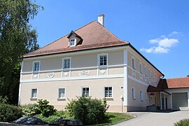
 Ping Garden (2017)
|
||

Pingarten is a district of the municipality of Bodenwöhr in the Upper Palatinate district of Schwandorf ( Bavaria ).
geography
Pingarten is located in the east of Bavaria in the Upper Palatinate in the Upper Bavarian Forest Nature Park on state road 2398 from Neunburg vorm Wald to Bodenwöhr.
history
Pingarten came into the possession of the Ensdorf monastery around 1166. Heilwig, the wife of Gebhard I von Leuchtenberg, bequeathed her property there to the monastery for the salvation of his son Friedrich's death. In 1316 Heinrich the Dachshölrer received the Maierhof or the bailiwick over Naelestorf and Pingarten, whereby he was obliged to provide further services by King Ludwig. On January 20, 1360 Ruprecht the Dachhoeler fiefdom owner of Pingarten. A document from 1366 proves that the rear residents of Pingarten were granted a right to use a piece of forest. In the battle of Hiltersried in 1433 over 130 poorly equipped soldiers were killed who belonged to the approximately 1000 men strong Upper Palatinate contingent. There were three soldiers from Pingarten. At the beginning of the 15th century, Örtlein Zenger zum Zangenstein was enfeoffed with the village of Pissau and Pingarten . In 1454 Hilpolt Steiner gave the bailiwick over Pingarten to his son-in-law Hans Bettendorfer zu Bettendorf. Around 1736, the Schwarzhofen monastery held the tithing of Pingarten.
Church history
The church visit protocol from the years 1582/83 lists Pingarten among other places under the Penting parish. After the secularization , the church council in Amberg had the sovereignty of the parish Schwarzhofen , to which Pingarten belonged among others.
Tax district
In a directory from 1762, 21 subjects are listed in Pingarten. At the beginning of the 19th century, the tax district Taxöldern included Pingarten, Taxöldern, Turesbach and Ziegelhütte. The Kingdom of Bavaria was divided into 15 districts in 1808. These districts were named after rivers based on the French model ( Naabkreis , Regenkreis , Unterdonaukreis , etc.). The districts were divided into district courts. The district court district Neunburg vorm Wald had 55 tax districts, including Taxöldern with Pingarten, Turesbach and Ziegelhütte.
Church building
The district courts should in turn be divided into individual municipality areas. In 1820/21 the municipality of Taxöldern was established with 26 families, Pingarten with 12 families and the hamlet of Turesbach with 3 families. In the period that followed, the towns of Höcherhof, Kipfenberg, Pingarten, Turesbach and Ziegelhütte belonged to the municipality of Taxöldern. On July 1, 1972 the municipality Taxöldern was dissolved and incorporated into Bodenwöhr.
nature
South of Pingarten is the former quarry in the Pingarten porphyry . The abandoned quarry is one of the 100 most beautiful geotopes in Bavaria.
Ping Garden (2017)

Geotope (2017)
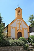
Village chapel (2017)

Ping Garden (2017)


Individual evidence
- ^ Wilhelm Nutzinger, Historical Atlas of Bavaria, Neunburg vorm Wald, p. 52
- ^ Wilhelm Nutzinger, Historical Atlas of Bavaria, Neunburg vorm Wald, pp. 64 and 208
- ^ Wilhelm Nutzinger, Historical Atlas of Bavaria, Neunburg vorm Wald, p. 52
- ^ Wilhelm Nutzinger, Historical Atlas of Bavaria, Neunburg vorm Wald, p. 123
- ^ Wilhelm Nutzinger, Historical Atlas of Bavaria, Neunburg vorm Wald, p. 121
- ↑ Monumenta Boica, 24/225
- ^ Wilhelm Nutzinger, Historical Atlas of Bavaria, Neunburg vorm Wald, p. 243
- ↑ State Archives Amberg, Religion and Reformation Files, No. 52/264
- ^ Wilhelm Nutzinger, Historical Atlas of Bavaria, Neunburg vorm Wald, p. 91
- ^ Wilhelm Nutzinger, Historical Atlas of Bavaria, Neunburg vorm Wald, p. 138
- ^ Ernst Emmering: The government of the Upper Palatinate, history of a Bavarian central authority. In: Contributions to the history and regional studies of the Upper Palatinate. Issue 20, Regensburg 1981, p. 12ff.
- ^ Wilhelm Nutzinger, Historical Atlas of Bavaria, Neunburg vorm Wald, p. 369
- ^ Wilhelm Nutzinger, Historical Atlas of Bavaria, Neunburg vorm Wald, p. 421
- ^ Wilhelm Nutzinger, Historical Atlas of Bavaria, Neunburg vorm Wald, p. 434
literature
- Wilhelm Nutzinger: Historical Atlas of Bavaria, Part of Old Bavaria, Issue 52, Neunburg vorm Wald , Munich 1982, ISBN 3-7696-9928-9
- Amberg State Archives, Religion and Reformation Files, No. 52/264
- Monumenta Boica, vol. 24
- Ernst Emmering: The government of the Upper Palatinate, history of a Bavarian central authority. In: Contributions to the history and regional studies of the Upper Palatinate. Issue 20, Regensburg 1981
Web links

Altenschwand | Altenschwand (train station) | Tin hammer | Bodenwohr | Book | Ore houses | Höcherhof | Kipfenberg | Mappenberg | Neuenschwand | Bad luck mill | Ping garden | Taxöldern | Turesbach | Warmersdorf | Wind corn