
District of Coburg
| coat of arms | Germany map |
|---|---|

|

Coordinates: 50 ° 16 ' N , 10 ° 56' E |
| Basic data | |
| State : | Bavaria |
| Administrative region : | Upper Franconia |
| Administrative headquarters : | Coburg |
| Area : | 590.47 km 2 |
| Residents: | 86,747 (Dec. 31, 2019) |
| Population density : | 147 inhabitants per km 2 |
| License plate : | CO, NEC |
| Circle key : | 09 4 73 |
| NUTS : | DE247 |
| Circle structure: | 17 municipalities |
| Address of the district administration: |
Lauterer Str. 60 96450 Coburg |
| Website : | |
| District Administrator : | Sebastian Straubel ( CSU ) |
| Location of the district of Coburg in Bavaria | |
 .svg) |
|
The district of Coburg is located in the northwest of the administrative district of Upper Franconia in Bavaria . The independent city of Coburg is completely surrounded by the district of Coburg. The district is a member of the Nuremberg Metropolitan Region .
geography
location
The northwest of the district forms a gently undulating (300- 500 m above sea level. NN ) plateau, which is mainly used as farmland. The northern part of the district is counted to the foreland of the Thuringian Forest and already has a clear low mountain range character ; except for cleared areas, it is characterized by extensive deciduous forests. Between these two landscapes lies the limestone range of the Long Mountains , whose barren soil is covered by coniferous forests. The Lauterberg nature reserve is located in the Long Mountains . The Buchberg near Rottenbach is 528 m above sea level. NN the highest point in the district. In the south, which extends to the Franconian Keuper - Lias Itz Hill Country (250- -Land owned 300 NN m above sea level. ).
Neighboring areas
The district borders clockwise, beginning in the northwest, on the districts of Hildburghausen and Sonneberg (both in Thuringia ) and on the districts of Kronach , Lichtenfels , Bamberg and Haßberge (all in Bavaria).
history
Until 1919
Coburg and Saalfeld were first mentioned in 1012 as a dowry for Count Palatine Ehrenfried (Ezzo) of Lorraine , from whose daughter Richeza the lordship passed to Archbishop Anno II of Cologne in 1056 .
In the following 300 years Andechs-Meranien , Wildberg and Henneberg as well as the monasteries Fulda , Hersfeld , Banz , Langheim , Mönchröden , Veilsdorf and Sonnefeld appeared as owners and rulers, until 1353 Margrave Friedrich III. the severity in the care Coburg ( House Wettin ), previously united by the Counts of Henneberg, took over the inheritance. Subsequently, the region belonged to the Electorate of Saxony , after 1547 to the Saxon Duchies and from 1826 until the end of the monarchy (1918) to the Duchy of Saxony-Coburg and Gotha .
In 1858 the Duchy of Saxony-Coburg introduced a separation of administration and justice. The district office of Coburg was established from the districts of the justice offices of Coburg II (district), Neustadt and Rodach, established in 1802 and 1807, as well as the Sonnefeld office, which was added in 1826. The Coburg I Justice Office comprised the city of Coburg. In 1877 the Königsberg district was also assigned to the Coburg District Office. The previous judicial offices were then referred to as local courts, whereby the judicial offices Coburg I and Coburg II were combined to form the Coburg District Court. The cities of Coburg, Neustadt, Rodach and Königsberg were not subordinate to the Coburg District Office. They had their own magistrate constitution.
District Office
After a referendum in 1919, the Free State of Coburg (essentially identical to today's city and district of Coburg) was united with the Free State of Bavaria on July 1, 1920 . The Free State of Bavaria adapted the administrative structure in the former Duchy of Saxony-Coburg to the rest of the state. The district office of Coburg became the district office of Coburg , which was responsible for the district court districts of Coburg, Neustadt bei Coburg, Rodach and Sonnefeld. The Coburg communities of Altershausen , Dörflis , Erlsdorf , Hellingen , Köslau , Kottenbrunn and Nassach , which had formed several exclaves , were assigned to the Hofheim district office in Lower Franconia . The cities of Coburg, Neustadt bei Coburg and Rodach were continued as district immediate cities in Upper Franconia, while the city of Königsberg was incorporated into the district office of Hofheim in Lower Franconia. In 1921 the district court districts of Coburg, Neustadt bei Coburg, Rodach, Sonnefeld and Königsberg were combined to form the Coburg district court, with the Königsberg and Sonnefeld district courts being repealed in 1925 and 1929, respectively.
On January 1, 1931, the communities of Altenhof with the places Tambach and Hergramsdorf and Schorkendorf with the places Eicha , Krebsmühle, Siebenwind and Ziegelhütte were taken over from the Staffelstein district office .
On July 1, 1934, the city of Coburg was enlarged to include the municipalities of Cortendorf , Ketschendorf , Neuses bei Coburg and Wüstenahorn of the district office.
district
On January 1, 1939, as everywhere in the German Reich, the designation district was introduced. This is how the district office became the district of Coburg.
On January 1, 1940, the independent cities of Neustadt bei Coburg and Rodach were incorporated into the Coburg district.
The district had survived the Second World War relatively undamaged and was occupied by the 11th US Armored Division in April 1945 and part of the American occupation zone , while the Thuringian hinterland belonged to the Soviet occupation zone and was cut off by the zone border until 1949 and the inner German border from 1949. The district was thus in the border area .
On June 7, 1946, Neustadt was again detached from the Coburg district. Coburg has always been preserved as an independent city.
On January 1, 1972, the district ceded the communities of Lützelbuch , Rögen and Seidmannsdorf to the independent city of Coburg. On the same day he lost the municipality of Ketschenbach to the independent city of Neustadt near Coburg.
By the local government reform on the restructuring of the Bavarian districts 1 July 1972 the Coburg were the city Neustadt bei Coburg the former, parts of the district Staffelstein with Sesslach and the community Witzmannsberg (as a new part of the municipality maple) as well as the community Heilgersdorf the district boars assigned . At the same time, the communities of Hofsteinach , Horb an der Steinach , and Leutendorf b. Coburg in the district of Kronach.
The district seat remained the independent city of Coburg, which was enlarged by incorporating the communities of Beiersdorf bei Coburg , Creidlitz and Scheuerfeld of the district. The city of Neustadt bei Coburg was given the status of a large district town as a replacement for the loss of district freedom .
On January 1, 1975, the Coburg district ceded the Freiberg community to the Lichtenfels district. There it was incorporated into Eggenbach .
On July 1, 1976, the district ceded the Neu- und Neershof community and on January 1, 1977 the Bertelsdorf community to the independent city of Coburg.
On January 1, 1978, the district of Coburg was enlarged to include Neuensorg ( incorporated into Weidhausen near Coburg ) and Forsthub ( incorporated into Grub am Forst ) of the Lichtenfels district.
On May 1, 1978, the Mödlitz district of the community of Weidhausen near Coburg was reclassified to the community of Schneckenlohe in the Kronach district. The district of Coburg reached its present size.
In the 1960s there were 129 municipalities in the district area and before the effective date of the municipal reform on May 10, 1978, there were still 51 municipalities. Today 17 cities and municipalities remain.
Population development
In the period from 1988 to 2018, the district grew from 82,144 to 86,906 by 4,762 inhabitants or 5.8%. On December 31, 1999, the district had the highest population with 92,304.
The following figures refer to the territorial status on May 25, 1987.
| Population development | ||||||||||||||
|---|---|---|---|---|---|---|---|---|---|---|---|---|---|---|
| year | 1840 | 1900 | 1939 | 1950 | 1961 | 1970 | 1987 | 1991 | 1995 | 2000 | 2005 | 2010 | 2015 | |
| Residents | 33,487 | 45.169 | 53,336 | 79,307 | 80,676 | 85.161 | 82.033 | 86,958 | 91,098 | 92.243 | 91,325 | 88.193 | 86,599 | |
economy
The industrialization began in Coburg very early. Coburg is one of the oldest industrial regions in Bavaria. Today the Coburg area is one of the most industrialized regions in Germany (approx. 280 industrial jobs per 1000 inhabitants), predominantly characterized by small and medium-sized enterprises.
The old industries in particular have a decisive influence on the structure
- Upholstered furniture and wood processing industry (1/3 of the German upholstered furniture production)
- Toy industry and Christmas tree decorations
- Basketry and pram production
- ceramic industry ( porcelain and industrial ceramics )
- Mechanical and plant engineering
as well as electrical engineering .
As of 2011, the five largest employers in the Coburg district are the Habermaaß family of companies in Bad Rodach (approx. 2000 employees), Valeo Klimasysteme in Bad Rodach (730 employees), Saint Gobain Industriekeramik in Rödental (650 employees), and Schumacher Packaging in Ebersdorf Coburg (600 employees) and the Schillig Polstermöbelwerke in Ebersdorf near Coburg (555 employees). Since after the German reunification, the zone border funding ceased, a structural change is currently taking place - reinforced by the EU expansion to the east and the economic crisis - to which many jobs and companies are falling victim. As a result of this development, the unemployment rate rose from around 3% in the 1980s to 10.5% (November 2003). In 2013 it was 4.1%. The Neukirchen youth center should be mentioned as a social institution .
politics
District Administrator
Sebastian Straubel (CSU) has been the district administrator since February 12, 2019. He prevailed in the runoff election on February 10, 2019 with 62.45% against the SPD candidate Martin Stingl (37.55%). His predecessor in the office of District Administrator from 2008 to 2018 was Michael C. Busch (SPD), who prevailed in the runoff election on March 16, 2008 with 52.52% of the votes against State Secretary Jürgen W. Heike (CSU) and in 2014 with 62 , 95% was confirmed in office. Because of Busch's entry into the Bavarian state parliament, early elections were necessary.
District administrators in the district of Coburg
- Adolf von Wangenheim (July 1st, 1858 - November 30th, 1865)
- Wilhelm Ewald (December 1, 1865 - June 30, 1872)
- Reinhold Erhardt (July 1, 1872 - November 7, 1885)
- Ernst Gruner ( provisional as assessor ) (November 8th, 1885 - March 30th, 1886)
- Ernst Schmidt (April 1, 1886 - March 31, 1894)
- Albert Schmidt (April 1, 1894 - May 31, 1912)
- Hermann Quarck (August 1, 1912 - May 31, 1914)
- Ernst von Strenge (June 1, 1914 - May 31, 1921)
- Ernst Fritsch (June 1, 1921 - March 4, 1933)
- Franz Dehler ( District Administrator) (May 5, 1933 - July 27, 1938)
- Gerhart Derks (August 1, 1938 - May 20, 1943)
- Georg Finck (May 26, 1943 - April 1945)
- Carl Escher ( provisionally as Government Inspector ) (04/20/1945 - 08/05/1945)
- Eduard Schmidt ( acting ) (May 9, 1945 - May 11, 1945)
- Karl Kokott ( acting as captain of the security police ) (May 12, 1945 - June 23, 1945)
- Karl Bauer ( provisional as a member of the government ) (June 24, 1945 - June 14, 1946)
- Rudolf Kaemmerer (June 14, 1946 - April 30, 1964)
- Klaus Groebe (May 1, 1964 - June 30, 1972)
- Helmut Knauer (July 1, 1972 - April 30, 1990)
- Karl Zeitler (May 1, 1990 - April 30, 2008)
- Michael C. Busch (May 1, 2008 - November 5, 2018)
- Rainer Mattern (November 5th, 2018 - February 11th, 2019) as elected deputy of the district administrator
- Sebastian Straubel (since February 12, 2019)
District council
The district council consists of 60 district councilors and the district administrator and is composed as follows due to the local election on March 15, 2020 :
| Political party | Seats |
|---|---|
| CSU / rural people | 18th |
| SPD | 12 |
| Free voters | 12 |
| GREEN | 7th |
| Independent county citizens | 4th |
| AfD | 3 |
| ÖDP | 2 |
| FDP | 1 |
| Die Linke / SBC-Land | 1 |
| total | 60 |
coat of arms
|
|
Blazon : “Split; in front the Bavarian diamonds, in the back divided nine times by black and gold, covered with an inclined and curved green diamond wreath. " |
|
Justification for the coat of arms: The front half of the coat of arms emphasizes the state affiliation and the property of the coat of arms owner as a Bavarian district after the annexation of the Free State of Coburg to Bavaria.
The back half of the coat of arms, on the other hand, indicates the centuries-old connection with Saxony through the main coat of arms of the Wettins with the diamond wreath . |
In addition to the coat of arms, the district also uses a logo.
population

The Coburg region was settled by the Thuringians until the 6th century and conquered by the Franks during the Great Migration . Slavic Wends and Sorbs immigrated in East Franconia . The dialect of the region is Itzgründische , a dialect of the Main Franconian .
After the Second World War , many refugees from the eastern regions settled in Coburg. In 1946 the district had more than 61,000 inhabitants compared to 40,000 in 1939.
traffic
rail

The Werra-Eisenbahn-Gesellschaft , in whose share capital the Duchy of Saxony-Coburg and Gotha was involved, set up its first line in 1858, the Werra Railway from Eisenach via Meiningen-Eisfeld to Coburg. To the north there was a branch line from Coburg to Sonneberg , which was later continued to Lauscha and Ernstthal am Rennsteig . The connection to Lichtenfels was established in 1859 together with the Kingdom of Bavaria . In 1892 the first local railway was added on the Coburg – Bad Rodach line.
The Prussian State Railroad opened further branch lines : in
1900 the Itzgrundbahn , branching off in Creidlitz, to Rossach and in 1901 the Steinachtalbahn , branching off in Ebersdorf, to Weidhausen; This was continued in 1920 by the Deutsche Reichsbahn in a ring to Neustadt on the Coburg – Sonneberg – Ernstthal line on the Rennsteig .
The Bavarian state railway operated from 1913 with its local railway Bamberg-Dietersdorf the city Sesslach and some communities in the West of the circle.
The entire network, which is 105 kilometers long (18 of which in the urban district of Coburg) is today only served half (50 km) by passenger traffic. Closures (55 km) took place:
- 1945: Fürth am Berg – Heubisch-Mupperg – Neustadt (4 km)
- 1945/50: Eisfeld – Görsdorf – Tiefenlauter – Coburg (15 km)
- 1975: Breitengüßbach – Kaltenbrunn-Untermerzbach – Memmelsdorf – Dietersdorf (15 km)
- 1975: Ebersdorf near Coburg - Hof-Steinach - Fürth am Berg (23 km)
- 1984: Creidlitz – Rossach (8 km)
Rail traffic is currently of little importance, especially because the Werra Railway no longer exists as a west-east connection. The high-speed line Nuremberg – Erfurt for the ICE from Munich to Berlin was opened in December 2017.
Street
Coburg was also poorly connected by road, as there was hardly any through traffic in the region until German reunification in 1990 . Road traffic was dominated by the federal highway 4 , which as a north-south axis connects the Nuremberg area with Thuringia and the B 303 , which connects Schweinfurt with the Czech Republic as a west-east axis. As part of the German Unity transport project , the federal motorway 73 (Nuremberg – Lichtenfels) was extended via Coburg to Suhl and has been continuously passable since September 5, 2008.
International partnerships
In 2012, the majority of the Coburg District Council passed a fundamental decision to enter into a regional partnership with a region in Turkey. After presenting two Turkish regions in December 2014, the District and Strategy Committee decided to intensify relations with Manisa in western Turkey. The Turkish partner invited a delegation from the Coburg district to sign a cultural agreement in Manisa. This was signed in April 2016 and includes the agreement of deeper cooperation in the areas of culture, economy, youth and administration. The district of Coburg is the fourth district in Bavaria (out of 71 districts) to have such a partnership with Turkey.
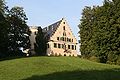
Attractions
- Maple Castle , maple
- Device Museum of the Coburg Land , Ahorn
- Hohenstein Castle , Hohenstein part of the Ahorn community
- Rosenau Castle , Rödental
- Tambach Castle , Tambach
- Tambach Wildlife Park , Tambach
- Sonnefeld Monastery , Sonnefeld
- Mönchröden Monastery , Rödental

Maple Castle

Castle Hohenstein
Rosenau Castle

Tambach Castle


Protected areas
In the district of Coburg there are 17 nature reserves , twelve landscape protection areas , 21 FFH areas and 17 geotopes designated by the Bavarian State Office for the Environment . (As of August 2016)
See also:
- List of nature reserves in the Coburg district
- List of landscape protection areas in the district of Coburg
- List of FFH areas in the district of Coburg
- List of geotopes in the district of Coburg
Communities
(Population figures as of December 31, 2019)
Unregulated areas (6.02 km²)
|
Other communities
|
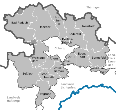  |
The following municipalities in the district have lost their independence since 1972:
|
|
Municipalities of the district before the territorial reform 1971/78
Until the territorial reform in 1971/78, the Coburg district had a total of 133 municipalities (see list below).
After 1945 the district bordered the German Democratic Republic in the west and north . In the southeast, the district bordered on the Kronach district , in the south on the Lichtenfels district, and in the southwest on the Staffelstein district . In contrast to today, not only was Coburg a district-free city , but also Neustadt b.Coburg . As it is today, the city of Coburg was the seat of the district administration.
The municipalities of the district of Coburg between 1921 and the municipality reform 1971/78 :. (The churches that still exist today are in bold .)
Other former municipalities of the old district of Coburg were:
- Rosenau , on April 1, 1928 in Unterwohlsbach
- Schweighof , on April 1, 1928 to Elsa and
- Taimbach , on April 1, 1928 in Fornbach.
License Plate
On July 1, 1956, the district was assigned the distinctive symbol CO when the vehicle registration number that is still valid today was introduced . It is still issued today. Since July 10, 2013, the license plate liberalization has also made the distinguishing mark NEC (Neustadt bei Coburg) available. Since December 1, 2014, vehicle registration has been carried out jointly with the independent city of Coburg in the Coburg Registration Office .
literature
- District Office Coburg: The Coburg region - very personal. neomediaVerlag, Coburg 2012, ISBN 978-3-931334-69-7 .
Web links
- Official website of the district
- Youtube channel of the district
- Region-Coburg.de Official portal of the district of Coburg with current news, videos and an event calendar
- Literature from and about the district of Coburg in the catalog of the German National Library
- Entry on the coat of arms of the district of Coburg in the database of the House of Bavarian History
Individual evidence
- ↑ "Data 2" sheet, Statistical Report A1200C 202041 Population of the municipalities, districts and administrative districts 1st quarter 2020 (population based on the 2011 census) ( help ).
- ^ Law on the Organization of Administrative Authorities in the Duchy of Coburg, dated June 17, 1858
- ^ Wilhelm Volkert (ed.): Handbook of Bavarian offices, communities and courts 1799–1980 . CH Beck, Munich 1983, ISBN 3-406-09669-7 , p. 97 .
- ^ Wolfgang Braunschmidt: Sebastian Straubel wins the district administrator's runoff election. np-coburg.de, February 10, 2019, accessed on February 12, 2019 .
- ↑ https://www.np-coburg.de/region/coburg/Landratswahl-findet-im-Januar-statt;art83420,6395809
- ↑ Entry on the coat of arms of the district of Coburg in the database of the House of Bavarian History , accessed on September 4, 2017 .
- ↑ "Data 2" sheet, Statistical Report A1200C 202041 Population of the municipalities, districts and administrative districts 1st quarter 2020 (population based on the 2011 census) ( help ).
- ^ Michael Rademacher: German administrative history from the unification of the empire in 1871 to the reunification in 1990. Coburg district. (Online material for the dissertation, Osnabrück 2006).
- ↑ BayernViewer of the Bavarian Surveying Administration (accessed on June 27, 2010)

Independent cities: Amberg | Ansbach | Bamberg | Bayreuth | Coburg | Erlangen | Fürth | Yard | Nuremberg | Schwabach | Willows in the Upper Palatinate
Districts: District of Amberg-Sulzbach | District of Ansbach | Bamberg district | Bayreuth district | District of Coburg | District of Erlangen-Höchstadt | Forchheim district | Fürth district | District of Haßberge | District of Kitzingen | District of Kronach | District of Kulmbach | District of Lichtenfels | District of Neumarkt idOPf. | District Neustadt adAisch-Bad Windsheim | District Neustadt ad Waldnaab | District of Nürnberger Land | District of Roth | District of Sonneberg | District of Tirschenreuth | Weißenburg-Gunzenhausen district | District of Wunsiedel in the Fichtel Mountains
Districts:
Aichach-Friedberg |
Altötting |
Amberg-Sulzbach |
Ansbach |
Aschaffenburg |
Augsburg |
Bad Kissingen |
Bad Toelz-Wolfratshausen |
Bamberg |
Bayreuth |
Berchtesgadener Land |
Cham |
Coburg |
Dachau |
Deggendorf |
Dillingen on the Danube |
Dingolfing-Landau |
Danube Ries |
Ebersberg |
Eichstätt |
Erding |
Erlangen-Höchstadt |
Forchheim |
Freising |
Freyung-Grafenau |
Fürstenfeldbruck |
Fürth |
Garmisch-Partenkirchen |
Gunzburg |
Hatred Mountains |
Yard |
Kelheim |
Kitzingen |
Kronach |
Kulmbach |
Landsberg am Lech |
Landshut |
Lichtenfels |
Lindau (Lake Constance) |
Main-Spessart |
Miesbach |
Miltenberg |
Mühldorf am Inn |
Munich |
Neuburg-Schrobenhausen |
Neumarkt in the Upper Palatinate |
Neustadt an der Aisch-Bad Windsheim |
Neustadt an der Waldnaab |
Neu-Ulm |
Nuremberg Country |
Oberallgäu |
Ostallgäu |
Passau |
Pfaffenhofen an der Ilm |
Rain |
Regensburg |
Rhön-Grabfeld |
Rosenheim |
Roth |
Rottal-Inn |
Schwandorf |
Schweinfurt |
Starnberg |
Straubing Arch |
Tirschenreuth |
Traunstein |
Unterallgäu |
Weilheim-Schongau |
Weißenburg-Gunzenhausen |
Wunsiedel in the Fichtel Mountains |
Wurzburg
Independent cities:
Amberg |
Ansbach |
Aschaffenburg |
Augsburg |
Bamberg |
Bayreuth |
Coburg |
Erlangen |
Fürth |
Hof (Saale) |
Ingolstadt |
Kaufbeuren |
Kempten (Allgäu) |
Landshut |
Memmingen |
Munich |
Nuremberg |
Passau |
Regensburg |
Rosenheim |
Schwabach |
Schweinfurt |
Straubing |
Willows in the Upper Palatinate |
Wurzburg