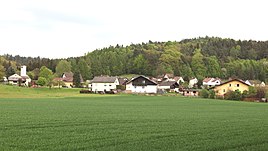
Waltersdorf (Rödental)
|
Waltersdorf
City of Rödental
Coordinates: 50 ° 19 ′ 26 ″ N , 11 ° 1 ′ 55 ″ E
|
|
|---|---|
| Height : | 341 m above sea level NN |
| Residents : | 85 (2010) |
| Incorporation : | 1st January 1971 |
| Incorporated into: | Frog base |
| Postal code : | 96472 |
| Area code : | 09563 |
|
Waltersdorf
|
|
Waltersdorf is a district of the Upper Franconian town of Rödental in the Coburg district .
geography
Waltersdorf is about nine kilometers northeast of Coburg in the Froschgrund, east of the Itz at the foot of the Sommerleite mountain. The left Itz tributary Höllgrund flows through the village. The state road St 2206 from Rödental to the Thuringian border crosses the town. A community road to Weimersdorf branches off from this.
history
The first documentary mention of Waltersdorf was in 1338 as "Walthersdorf". The settlement was probably named after a person of the same name.
At the beginning of the 14th century, Waltersdorf was under the rule of the Henneberger . In 1353 the place with the Coburg Land came by inheritance to the Wettins and was thus part of the Electorate of Saxony from 1485 , from which the Duchy of Saxony-Coburg later emerged. The lords of Schaumberg ruled the village. The Sonnefeld monastery owned the place.
Waltersdorf has been part of the church district of Weißenbrunn vorm Wald for centuries . In 1868 Gereuth, at the foot of the Hohen Schwenge, was united with Waltersdorf.
In a referendum on November 30, 1919, one citizen of Waltersdorf voted for the Free State of Coburg to join the Thuringian state and 37 against. Thus, from July 1, 1920, Waltersdorf belonged to the Free State of Bavaria . In 1925 the place had 67 inhabitants and 10 residential buildings. The Protestant school was in Mittelberg, 0.9 kilometers away .
On January 1, 1971, Waltersdorf merged with the towns of Fischbach , Fornbach , Schönstädt , Mittelberg and Weißenbrunn vorm Wald to form the new Froschgrund community, which was forcibly dissolved on May 1, 1978 and incorporated into the town of Rödental . Since then, Waltersdorf has been a district of Rödental.
Population development
|
Web links
Individual evidence
- ↑ a b c d e Festschrift 40 years Rödental, p. 33
- ↑ Horst GRASSMUCK: Place names of the county Coburg. Inaugural dissertation from the University of Erlangen 1955, p. 69.
- ^ Walter Lorenz: Campus Solis. History and property of the former Cistercian abbey of Sonnefeld near Coburg . Verlag Kallmünz, 1955, p. 240
- ^ Coburger Zeitung, issue no.280 from December 1, 1919
- ^ Localities directory for the Free State of Bavaria, based on the census of June 16, 1925, Munich, 1928
- ↑ Michael Scholz: AMNEM VISPACH 1162 - 2012. A contribution to the 850th anniversary of the Fischbach district on June 9 and 10, 2012 . Rödental 2012. p. 37
- ↑ Address manual of the Duchy of Saxony-Coburg and Gotha: 1837, p. 73
- ↑ www.gemeindeververzeichnis.de
- ↑ Michael Rademacher: German administrative history from the unification of the empire in 1871 to the reunification in 1990. City and district of Coburg. (Online material for the dissertation, Osnabrück 2006).
- ↑ Official directory for Bavaria, territorial status: May 25, 1987, Munich, 1991

