Kipfendorf
|
Kipfendorf
City of Rödental
Coordinates: 50 ° 17 ′ 13 ″ N , 11 ° 5 ′ 6 ″ E
|
|
|---|---|
| Height : | 381 m above sea level NN |
| Residents : | 291 (2010) |
| Incorporation : | 1st January 1971 |
| Postal code : | 96472 |
| Area code : | 09563 |
|
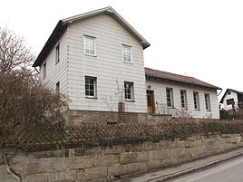
Old school
|
|
Kipfendorf is a district of the Upper Franconian town of Rödental in the Coburg district . On January 1, 1971, Kipfendorf belonged to the "founding communities" of Rödental along with the former communities of Einberg , Mönchröden , Oeslau , Rothenhof and Unterwohlsbach . Wilhelm Volkert (Hrsg.): Handbook of the Bavarian offices, communities and courts 1799–1980 . CH Beck, Munich 1983, ISBN 3-406-09669-7 , p. 442 .
geography
Kipfendorf is about nine kilometers northeast of Coburg at the western foot of the Stiefvater mountain. There are communal roads to Rothenhof and Blumenrod . The county road CO 11 passes to the east.
history
Kipfendorf was first mentioned in a document in 1314. Another documentary mention was made in 1317 in the Urbarium , a listing of possessions of the Henneberger when acquiring the New Rulership, as "Windischen Inberg". It was probably a daughter settlement of Inberg (Einberg). The current name first appeared in 1452 as "Kypfendorff". The name "Kipfe" means mountain peak or peak, so "village at the top", which refers to the neighboring mountain stepfather.
In 1353, the place with the Coburg Land was inherited by the Wettins and was thus part of the Electorate of Saxony from 1485 , from which the Duchy of Saxony-Coburg later emerged. In 1440 the Mönchröden monastery acquired the village. The inheritance book of the Coburg office recorded one farm and five Sölden in Kipfendorf in 1516 as lordly fiefs of the monastery.
In 1618, at the beginning of the Thirty Years War , the place had an estate and nine Sölden estates with a total of four horses, twenty cattle and twelve pigs. In 1630 three properties were still intact and there was one more cow. In 1658 there were again nine cattle and ten sheep. In 1783, Kipfendorf had 64 inhabitants who lived in fourteen houses. The place belongs to the parish of Einberg.
The economic development of Kipfendorf was shaped by a clay quarry southwest of the town center, where there was a pottery workshop as early as the 13th century. A brickworks is documented for 1617. The clays belonging to the Upper Keuper were finally mined from 1857 to 1930 in a 14-hectare mine by the Oeslauer Annawerk for the production of stoneware, clinker and refractory bricks of medium quality and initially transported by carts and from 1915 on a mine train for around five kilometers.
On July 21, 1869, Thierach with 26 inhabitants was forcibly incorporated into Kipfendorf with 110 inhabitants at that time.
The first association was founded in 1858 with a "reading club".
The Kipfendorfer children went to school in Einberg, about three kilometers away, from the 16th century. Later the village had a preceptor who alternately taught in one of the farmhouses and had board and lodging there. From 1842, the school in Einberg was responsible again, before Kipfendorf and Rothenhof left the Einberg school association in 1875 and set up a joint school in Kipfendorf. In 1908 the Rothenhofer pupils finally had their own school house. Since joining the Einberg School Association in 1967, students have been taking the school bus to Einberg.
In a referendum on November 30, 1919, one citizen of Kipfendorf voted for the Free State of Coburg to join the Thuringian state and 70 against. Thus from July 1, 1920 Kipfendorf belonged to the Free State of Bavaria .
On January 1, 1971, Kipfendorf merged with the communities of Einberg, Mönchröden, Oeslau, Rothenhof and Unterwohlsbach to form the unified community of Rödental. In 1987 the village comprised 215 people, 65 residential buildings and 86 apartments.
In 1991 Kipfendorf won the second prize in the competition “Our village should be more beautiful”. In 2007 the district got a village well made from Franconian shell limestone . It is a work by the sculptor Reinhard Klesse based on a design by Rödental's lithographer and artist Gerhard Seidel and shows motifs from farm work, the former clay pit and the school and reading club.
Population development
|
|
Web links
Individual evidence
- ↑ a b c d e Festschrift 40 years Rödental, p. 33
- ^ Walter Schneier: The Coburg country. 2nd edition, Coburg 1990. p. 111
- ↑ Horst GRASSMUCK: Place names of the county Coburg. Inaugural dissertation from the University of Erlangen 1955, p. 38.
- ↑ a b c d e f g h i Siegfried Zeltner: 675 years of Kipfendorf
- ^ Rainer Hambrecht: Contributions to the founding, ownership and economic history of the monastery Mönchröden. In: 850 years Mönchröden: The former Benedictine abbey from the first mention in 1149 until the Reformation. Series of publications by the Historical Society of Coburg Volume 13, Coburg 1999, p. 81.
- ↑ Annawerk A.-G. (Annawerk Oeslau b Coburg), Festschrift 80 years 1937, p. 35f
- ^ Coburger Zeitung, issue no.280 from December 1, 1919
- ↑ Festschrift 40 years Rödental, p. 14
- ↑ Official directory for Bavaria, territorial status: May 25, 1987, Munich, 1991
- ↑ ?? A dream came true ?? - www.np-coburg.de , July 10, 2007
- ↑ www.gemeindeververzeichnis.de
- ^ A b Michael Rademacher: German administrative history from the unification of the empire in 1871 to reunification in 1990. City and district of Coburg. (Online material for the dissertation, Osnabrück 2006).

