Birkig
|
Birkig
Large district town Neustadt near Coburg
Coordinates: 50 ° 17 ′ 14 ″ N , 11 ° 7 ′ 16 ″ E
|
|
|---|---|
| Height : | 360 m above sea level NN |
| Area : | 2.38 km² |
| Residents : | 105 |
| Population density : | 44 inhabitants / km² |
| Incorporation : | July 1, 1972 |
| Postal code : | 96465 |
| Area code : | 09568 |
|
lock
|
|
Birkig is a district of the Upper Franconian town of Neustadt bei Coburg in the Coburg district .
location
Birkig is about five kilometers south of Neustadt at the northern foot of the 120 meter higher Birkiger mountain. The district boundary corresponds to the Bavarian state border with Thuringia in the east . The communal roads from Birkig to Neustadt and from Horb to Boderndorf cross in the village.
history
The remains of a tower hill complex , the so-called Schnackenburg , are located northeast of the village. Birkig himself was first mentioned in 1317 in the Urbarium , a list of possessions of the Henneberger when the New Rulership acquired a castle property. The place name can be interpreted as a settlement on the birch grove.
In the 14th century the castle estate, which became a simple manor in 1446, came into the possession of the Counts of Birkig .
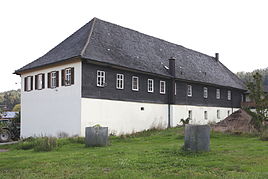
In 1499 the village consisted of two farms and four Sölden (part-time businesses). Half belonged to the von Birkig family. In 1515 the two farms were merged. In 1721 the indebted von Birkig family sold their manor to Georg Paul von Hendrich zu Ahorn, who had a new palace built in 1725 to replace a dilapidated previous building. The elongated building in the style of a manor house contains a barn, stable and apartment under one roof. In 1745 Hendrich sold the estate to Marie von Speßhardt for her son Wilhelm Ernst von Speßhardt zu Mupperg . The estate remained in the possession of this family until it was broken up due to high debts in 1881.
The plague killed seven people in Birkig in 1611. In 1646, towards the end of the Thirty Years' War, three of twelve Sölden houses were still habitable and none of the six men who were able to serve as military service were no longer in the team register. In 1783 the place had 69 inhabitants who lived in 11 houses.
In 1856 a brick and brick factory was built, and in 1857 there were 16 houses.
In a referendum on November 30, 1919, three citizens of Birkig voted for the Free State of Coburg to join the Thuringian state and 34 against. Thus, from July 1, 1920, Birkig belonged to the Free State of Bavaria .
In the Reichstag election of March 5, 1933 , the SPD in Birkig received as many votes as the NSDAP with 29 .
In the First World War, lost six and in the Second World War Birkiger ten soldiers their lives. After the Second World War, the proximity of the inner-German border shaped the place until 1989 .
In 1964, the community won the “The more beautiful village” competition in the Coburg district. The first prize, a frog fountain, was designed by the Munich sculptor Sebastian Holzner. He has been remembering the event since 1966.
In a public survey on January 23, 1972, 93.4% of those who voted decided to join Neustadt. As a result, Birkig gave up his self-employment and was incorporated into Neustadt on July 1, 1972.
The drinking water supply used to be through house wells. From 1965 the water supply was carried out by the Spittelsteiner Group, which was taken over in 1986 by the Neustadt municipal utilities. From 1922 the electricity supplier was the overland plant of the Gumpertschen mill in Mupperg and from October 1937 the Bamberg overland plant in Upper Franconia. In 1997 Stadtwerke Neustadt took over the power supply. In 1987, Birkig had 31 residential buildings, 12 of which were built after 1949.
Population development
|
Web links
Individual evidence
- ↑ http://www.neustadt-bei-coburg.de/leben-in-neustadt/rathaus/allgemeine-daten/stadtteile.html
- ↑ a b c Isolde Kalter: Birkig
- ^ Coburger Zeitung, issue No. 279 of December 1, 1919
- ↑ Helmut shy Erich: history of the city Neustadt bei Coburg in the twentieth century. First volume, 1989, p. 108
- ↑ Helmut shy Erich: history of the city Neustadt bei Coburg in the twentieth century. Second volume, 1993, p. 153
- ↑ Helmut shy Erich: history of the city Neustadt bei Coburg in the twentieth century. First volume, 1989, p. 28
- ↑ Helmut shy Erich: history of the city Neustadt bei Coburg in the twentieth century. First volume, 1989, pp. 378, 386
- ↑ Helmut shy Erich: history of the city Neustadt bei Coburg in the twentieth century. Second volume, 1993, p. 130
- ↑ a b c d e f Helmut Scheuerich: History of the city of Neustadt near Coburg in the twentieth century. Second volume, 1993, p. 128
- ^ Michael Rademacher: German administrative history from the unification of the empire in 1871 to the reunification in 1990. bay_coburg.html. (Online material for the dissertation, Osnabrück 2006).
