Neuhof and Neershof
|
Neuhof and Neershof
independent city of Coburg
Coordinates: 50 ° 16 ′ 2 ″ N , 11 ° 2 ′ 19 ″ E
|
|
|---|---|
| Height : | 340 m above sea level NN |
| Area : | 2.51 km² |
| Residents : | 251 (Jun 30, 2010) |
| Population density : | 100 inhabitants / km² |
| Incorporation : | July 1, 1976 |
| Postal code : | 96450 |
| Area code : | 09563 |
|
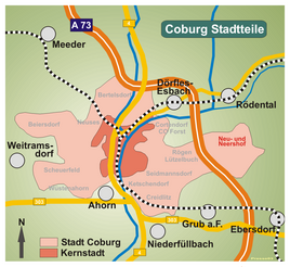
Location of Neuhof and Neershof in Coburg
|
|
Neu- und Neershof is a former municipality that was created in 1867 through the merger of Neuhof and Neershof and was dissolved in the Upper Franconian town of Coburg in 1976 .
geography
Neu- und Neershof has the character of a settlement like a village. It is located around six kilometers east of the city center and borders the Rögen district of Coburg and the communities of Ebersdorf and Rödental . The place consists of Neuhof, the settlement around Neuhof Castle , and Neershof with the upper and lower village, which have grown together over time. On June 30, 2010 Neu- und Neershof had 251 inhabitants, which results in a population density of 100 inhabitants per square kilometer.
Larger ponds, including the 4.5-hectare mill pond, are located in the west of Neershof, which is bordered in the south by the Lahm mountain ridge, which is up to 410 meters high. The highest point is at 407 meters in the Alexenschrotfeld area.
history
Neershof was first mentioned as "Neseldorf" in 1225. Until 1861, Neershof belonged as a fief to the owner of Neuhof Castle, which was first mentioned in 1371 as "Newenhoff" (new courtyard of the older Neershof settlement).
In 1867 Neershof was united with the Neuhof estate to form a political municipality with 104 inhabitants. The two places had a common mayor before . After the school in Einberg was built (around 1590), it was responsible for the students from Neuhof and Neershof. Due to the growing number of pupils, the community built a school in Neershof in 1902, which was inaugurated in 1903 and attended by 28 pupils. In 1914, 14 of the 30 eligible voters in municipal elections were employed in industry.
In the First World War the community counted 12 and in the Second World War 18 dead. In a referendum on November 30, 1919, four residents voted for the Free State of Coburg to join the Thuringian state and 45 against. From July 1, 1920, Neuhof and Neershof also belonged to the Free State of Bavaria . In 1967 the community was connected to the water network of the water association Spittelsteiner Gruppe.
Neuhof and Neershof belonged to the parish of the Protestant parish Einberg. After the citizens of Neu- and Neershofer had decided in a vote with 88.6 percent to belong to Coburg instead of Rödental, on July 1, 1976 the incorporation into Coburg with 251 hectares of parish area and 212 inhabitants took place.
Attractions
Population development
| year | population |
|---|---|
| 1867 | 104 |
| 1890 | 135 |
| 1910 | 155 |
| 1933 | 198 |
| 1946 | 276 |
| 1958 | 315 |
| 1961 | 300 |
| 1976 | 211 |
| 1987 | 207 |
| 2010 | 251 |
The population figures include the residents of the old people's home at Neuhof Castle that existed from 1952 to 1972.
literature
- Peter Morsbach, Otto Titz: City of Coburg. Ensembles-Architectural Monuments-Archaeological Monuments . Monuments in Bavaria. Volume IV.48. Karl M. Lipp Verlag, Munich 2006, ISBN 3-87490-590-X
- Otto Thurn: Neuhof and Neershof. History of a village from its origins to the present . Coburg 1980.
Web links
Individual evidence
- ^ Otto Thurn: Neuhof and Neershof. P. 146.
- ^ Otto Thurn: Neuhof and Neershof. P. 150.
- ^ Coburger Zeitung, issue No. 281 of December 2, 1919
- ↑ Harald Sandner: Coburg in the 20th century , p. 285.
- ↑ a b c d e f g h Otto Thurn: Neu- und Neershof. P. 155.
- ↑ Bavarian State Office for Statistics and Data Processing (Ed.): Official local directory for Bavaria, territorial status: May 25, 1987 . Issue 450 of the articles on Bavaria's statistics. Munich November 1991, DNB 94240937X , p. 287 ( digitized version ).
- ↑ City of Coburg: As of June 30, 2010


