Lützelbuch
|
Lützelbuch
independent city of Coburg
Coordinates: 50 ° 15 ′ 21 ″ N , 11 ° 0 ′ 44 ″ E
|
|
|---|---|
| Height : | 340 m above sea level NN |
| Area : | 1 km² |
| Residents : | 424 (Jun 30, 2010) |
| Population density : | 424 inhabitants / km² |
| Incorporation : | January 1, 1972 |
| Postal code : | 96450 |
| Area code : | 09561 |
|
Location of Lützelbuch in Coburg
|
|
Lützelbuch is an eastern part of the Upper Franconian city of Coburg .
geography
The smallest district in terms of area has the character of a settlement as a village. It borders on the Coburg districts of Cortendorf , Seidmannsdorf and Rögen as well as the community of Grub am Forst . On June 30, 2010 Lützelbuch had 424 inhabitants, which results in a population density of 424 inhabitants per km².
The Ketschenbach flows through Lützelbuch, which is bordered in the west by the 414 meter high Klausberg and in the southwest by the 376 meter high Johannesberg.
history
The place name can be derived from Dorf an der kleine Buche ("buoche"), but small Hofstatt ("bü (buwe)") is also conceivable.
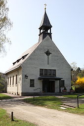
The first written mention of Lützelbuch dates back to 1496, when Albrecht von Brandenstein acquired a manor from Valentin Schenk that comprised around 200 hectares of land in Lützelbuch and Rögen. The manor, located northeast of the historic village center on a small rise, was owned by von Brandenstein until 1823. Then it came into the possession of Duke Ernst I. The ducal domain administration leased the property. Under Duke Ernst II , large parts of the property were sold to local farmers in 1872 and the farmhouse in the manor house was set up in 1873 along with the remaining seven hectares of land. After Coburg was annexed to Bavaria in 1920, the house became part of the Free State, which in 1923 transferred it to the Neuendettelsau deaconess institution on condition that a nursing home for old and frail people be established. The nursing home, the Laurentiushaus, has a chapel that was built in 1936 according to plans by the architect Max von Berg.
Due to the large number of students, in 1885 there were 20 Rögener and 64 Lützelbuch children, the two communities in Lützelbuch built a joint school, which was inaugurated on May 15, 1884 and was used until the 1968/69 school year.
In 1910 Lützelbuch had 367 inhabitants. In 1925 Lützelbuch had 61 residential buildings with 371 people, 370 of whom were Protestant. In 1939 there were 421 residents. On January 1st, 1972 Lützelbuch was incorporated into Coburg with 100 hectares of parish area and 534 inhabitants. In 1971 a sponsorship was established with Gais in South Tyrol and in 1973 a multi-purpose hall, a gift from the city of Coburg, was inaugurated.
Lützelbuch has been part of the parish of the Evangelical Lutheran parish Seidmannsdorf for centuries . In the Catholic Church, the place has belonged to the Coburg parish of St. Augustin since the 19th century .
coat of arms
The former municipal coat of arms shows a jumping wolf with a goose in its mouth. It goes back to the coat of arms of the Lords of Brandenstein.
Attractions
literature
- Lützelbuch Citizens 'Association: 1972–1997 25 years of the Lützelbuch Citizens' Association .
- Peter Morsbach, Otto Titz: City of Coburg. Ensembles-Architectural Monuments-Archaeological Monuments . Monuments in Bavaria. Volume IV.48. Karl M. Lipp Verlag, Munich 2006, ISBN 3-87490-590-X , pp. 453-455.
Web links
Individual evidence
- ^ Localities directory for the Free State of Bavaria, based on the census of June 16, 1925 and the territorial status of January 1, 1928, Munich, 1928, p. 1048
- ↑ Harald Sandner: Coburg in the 20th century , p. 270.


