
Meeder
| coat of arms | Germany map | |
|---|---|---|

|
Coordinates: 50 ° 19 ′ N , 10 ° 54 ′ E |
|
| Basic data | ||
| State : | Bavaria | |
| Administrative region : | Upper Franconia | |
| County : | Coburg | |
| Height : | 326 m above sea level NHN | |
| Area : | 73.59 km 2 | |
| Residents: | 3656 (Dec. 31, 2019) | |
| Population density : | 50 inhabitants per km 2 | |
| Postal code : | 96484 | |
| Area code : | 09566 | |
| License plate : | CO, NEC | |
| Community key : | 09 4 73 144 | |
| LOCODE : | DE ZJP | |
| Community structure: | 16 districts | |
| Address of the municipal administration: |
Bahnhofstrasse 1 96484 Meeder |
|
| Website : | ||
| Mayor : | Bernd Höfer ( CSU ) | |
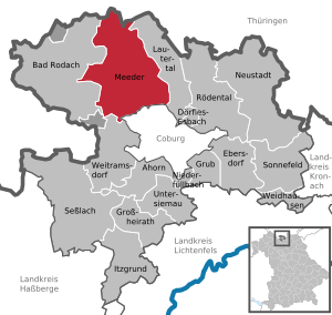
| Location of the community of Meeder in the district of Coburg | ||
  |
||


Meeder is a municipality in the Upper Franconian district of Coburg with around 3700 inhabitants.
geography
location
The municipality of Meeder is located in the valley basin of the Sulzbach, a tributary of the Lauter . The Rhine-Weser watershed runs through the north of the municipality, on the other side the Habergrund rises in the extreme north, which drains to the Werra .
To the north and northeast, the municipality has a share of the Long Mountains , while the Callenberger Forest extends to the south. The northern municipal border forms the state border with Thuringia .
Neighboring communities
Clockwise, starting in the north: Veilsdorf , Eisfeld , Lautertal , Coburg , Weitramsdorf , Bad Rodach .
Community structure
The community consists of the districts (former communities with their former districts):
|
history
Until the move to Bavaria
Meeder was first mentioned in a document in 1074. The place was granted market rights as early as 1125. It was one of the first Franconian places with market rights. Along with Fechheim, Meeder is an original parish in the Coburg region. The Coburg Land was Christianized from these two parishes. The Heiligkreuz parish in Coburg was a branch church of the Meeder St. Laurentius parish until the 13th century.
The Thirty Years War brought severe devastation to Meeder. 351 people died between 1634 and 1636 alone. In 1637 almost the whole village burned down. In the end, out of 2000 people, only 600 survived the Thirty Years War. 1650 ordered Duke Friedrich Wilhelm II. The celebration of a great thanksgiving and peace festival after Sunday Sebaldustag at (August 19) throughout the former principality. It has been celebrated in Meeder ever since. The tradition of the choir members (male church and trombone choir), who are always rewarded with food and drink for their annual work on this festival day, has been preserved to this day. Besides Augsburg, Meeder is the only place that has dedicated itself to this thanksgiving for peace.
In 1868, Birkenmoor joined Meeder. In 1892 Meeder got a connection to the railway network.
Incorporations
| Former parish | Residents (1970) | date | annotation |
|---|---|---|---|
| Ahlstadt | 248 | 07/01/1976 | |
| Beuerfeld | 180 | 10/01/1971 | |
| Drossenhausen | 102 | 07/01/1971 | with the district of Einzelberg |
| Great whale | 791 | 05/01/1978 | |
| Herbartsdorf | 38 | 1961 | to Wiesenfeld near Coburg |
| Kleinwalbur | 109 | 04/01/1971 | |
| Kosfeld | 39 | 1962 | to Wiesenfeld near Coburg |
| Mirsdorf | 63 | 07/01/1975 | |
| Moggenbrunn | 90 | 04/01/1971 | |
| Neida | 204 | 01/01/1976 | |
| Otto wind | 282 | 07/01/1975 | |
| Sulzdorf | 36 | 1964 | to Wiesenfeld near Coburg |
| Wiesenfeld near Coburg | 537 | 05/01/1978 |
Population development
In the period from 1988 to 2018, the municipality grew from 3543 to 3682 by 139 inhabitants or 3.9%. A peak was reached on December 31, 2000 with 4155 inhabitants.
politics
Municipal council
The 2020 local election resulted in the following distribution of seats in the local council (compared to the 2014 election)
- CSU / Landvolk 8 seats (+1)
- SPD 3 seats (−2)
- Free voters 5 seats (+1)
mayor
The first mayor was Josef Brunner (SPD) from 2002 until he was voted out of office in 2014. He was followed on May 1, 2014 by Bernd Höfer (CSU), who was re-elected in 2020.
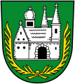
coat of arms

Current municipal coat of arms
Municipal coat of arms until 1986
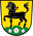
Coat of arms of the former municipality of Großwalbur

Coat of arms of the former municipality of Moggenbrunn


Blazon of the current coat of arms: "Under a shield head divided three times by black and gold, covered with a curved green diamond wreath, in green the silver church of Meeder on green ground."
Blazon of the earlier coat of arms: "In green a silver (white) church in side view with two pointed towers and a dome-covered roof turret, including two golden (yellow) palm branches."
The former coat of arms was awarded by a ministerial decision of August 13, 1957 and the current one by the Upper Franconian government on February 28, 1986. The coats of arms each show the old local church of St. Laurentius in its original Romanesque state. The picture comes from a seal from 1762. In the new coat of arms, the reduced Saxon coat of arms can be seen in the head of the shield, which indicates that the community previously belonged to the Duchy of Saxony-Coburg . In the old coat of arms palm branches can be seen as a Christian symbol of eternal life. The colors silver and green are the colors of Coburg.
Economy and Transport
The place Meeder is characterized by agriculture. Many residents work in Coburg. The castle brewery at the lower castle existed since 1727. Later it and the associated inn were moved to the center of the village. After the Meyer brewery, the Fink brewery produced the “Hansenbräu” beer from 1921 and the Sperber brewery from 1956 until the company was closed in 1983. The mechanical engineering company Hamuel, part of the Scherdel Group, is the largest employer in town with around 200 employees.
State road 2205 leads from Meeder to Coburg and Bad Rodach, via Unterlauter there is a connection to the B 4 , via Weitramsdorf you are connected to the B 303 and all other districts can be reached via communal or district roads. The place Meeder is with one stop on the Coburg – Bad Rodach railway line , which serves two more stops in the municipal area in Wiesenfeld and Großwalbur.
The A 73 Suhl - Nuremberg runs through the north of the municipality . The Coburg-Nord junction (AS 7) is about 8 km southeast of Meeder.
Culture and sights
Museums

The Meeder Peace Museum was founded in 1982 by the pastor Karl Eberhard Sperl and housed in the old school community center. To enable an expansion and a new conception, 47 women and men with the participation of the parish of St. Laurentius and the political community founded the Meeder Peace Museum.
Exhibits include cartridges forged into crosses by child soldiers in Africa, jugs made from bullet casings from the First World War, a Wehrmacht helmet reforged into a kitchen strainer from the Second World War, and a wedding dress that was sewn from a military parachute in 1946 due to the lack of other material. In addition to the previous focus of the museum, such as “War implements for peace tools” (similar to the motto “ Swords for plowshares ” of the peace movement in the GDR at the beginning of the 1980s) and the conflict between the Church and National Socialism from 1934 to 1945, the contemporary witness project “Say how was that back then? ”with the description of personal experiences from the Nazi dictatorship , the Second World War and the post-war period. A special exhibition is dedicated to the Coburg peace activist Anna Bernhardine Eckstein (1868 to 1947), contemporary and to some extent companion of the Nobel Peace Prize winners Bertha von Suttner and Ludwig Quidde . A redesign took place in 2011 after the move from the old school to the Anna-B.-Eckstein-Schule.
Buildings
The church of St. Laurentius has two towers as an architectural feature. The baroque organ dates from 1723. Johann Nikolaus Forkel , born in Meederer, first Bach biographer and founder of modern musicology, made his first musical attempts on it.
Also worth mentioning are the Sternberg Castle, also known as the Lower Castle, the Moggenbrunn moated castle and a communal sheepfold from the 18th century.
Architectural monuments
Meeder transmitter
On the Sennigshöhe (geographical coordinates: 50 ° 21 ′ 20 ″ N , 10 ° 54 ′ 56 ″ E ), Deutsche Telekom AG has been operating a transmission system for VHF radio , mobile radio and directional radio since 1965 .
Personalities
- Johann Nikolaus Forkel (1749–1818), born in Meeder, organist and music researcher

Evangelical Church of St. Bonifatius in Ahlstadt

Evangelical parish church St. Oswald in Großwalbur

Evangelical branch church St. Bartholomäus in Ottowind

Magdalenenkirche in Wiesenfeld


Individual evidence
- ↑ "Data 2" sheet, Statistical Report A1200C 202041 Population of the municipalities, districts and administrative districts 1st quarter 2020 (population based on the 2011 census) ( help ).
- ^ A b c Walter Schneier: Coburg in the mirror of history , Neue Presse Coburg, 1985
- ↑ Eva Herold, Robert Wachter: Moggenbrunn The golden village, the farmers and the castle . Meeder 1994, p. 127
- ↑ a b c d e f Federal Statistical Office (ed.): Historical municipality register for the Federal Republic of Germany. Name, border and key number changes in municipalities, counties and administrative districts from May 27, 1970 to December 31, 1982 . W. Kohlhammer GmbH, Stuttgart / Mainz 1983, ISBN 3-17-003263-1 , p. 679 and 680 .
- ↑ a b c d e f g Wilhelm Volkert (Ed.): Handbook of the Bavarian offices, municipalities and courts 1799–1980 . CH Beck, Munich 1983, ISBN 3-406-09669-7 , p. 441 f .
- ↑ Klemens Stadler, Albrecht von und zu Egloffstein: The coats of arms of the Upper Franconian districts, cities, markets and communities. (Die Plassenburg, writings for local research and cultural maintenance in East Franconia 48), Kulmbach 1990, ISBN 3-925162-17-8 , p. 116 and p. 268
- ^ Wolfgang Vatke: Coburg breweries city and country . Veste-Verlag Roßteutscher, Coburg 2008, ISBN 978-3-925431-03-6 , p. 217
Web links
- Entry on Meeder's coat of arms in the database of the House of Bavarian History
- Meeder: Official statistics of the LfStat (PDF, 1.66 MB)
- Meeder Peace Museum

Maple | Bad Rodach | Dörfles-Esbach | Ebersdorf near Coburg | Great marriage | Grub am Forst | Itzgrund | Lautertal | Meeder | Neustadt bei Coburg | Niederfüllbach | Rödental | Seßlach | Sonnefeld | Untersiemau | Weidhausen near Coburg | Weitramsdorf
Unregulated areas of
Callenberger Forst-West |
Gellnhausen |
Köllnholz
Ahlstadt | Beuerfeld | Birch moor | Drossenhausen | Single mountain | Great whale | Herbartsdorf | Kleinwalbur | Kösfeld | Mirsdorf | Moggenbrunn | Neida | Otto wind | Sulzdorf | Meadow field