
Lautertal (Upper Franconia)
| coat of arms | Germany map | |
|---|---|---|

|
Coordinates: 50 ° 19 ′ N , 10 ° 59 ′ E |
|
| Basic data | ||
| State : | Bavaria | |
| Administrative region : | Upper Franconia | |
| County : | Coburg | |
| Height : | 323 m above sea level NHN | |
| Area : | 30.35 km 2 | |
| Residents: | 4330 (Dec. 31, 2019) | |
| Population density : | 143 inhabitants per km 2 | |
| Postal code : | 96486 | |
| Primaries : | 09561, 09566 | |
| License plate : | CO, NEC | |
| Community key : | 09 4 73 141 | |
| Community structure: | 6 districts / districts | |
| Address of the municipal administration: |
Frankenstrasse 3 96486 Lautertal |
|
| Website : | ||
| Mayor : | Karl Kolb (ÜPW) | |
| Location of the community Lautertal in the district of Coburg | ||
  |
||


Lautertal is a municipality in the Upper Franconian district of Coburg . The name is a new creation on the occasion of the establishment of the municipality as part of the regional reform in Bavaria on July 1, 1969. The inspiration was the Lauter , which flows into the Itz and flows through the municipality from north to south (in the northernmost section of the right source stream Rottenbach ). There is no district or a district called Lautertal . The seat of the municipal administration is the Oberlauter district .
geography
Lautertal is located in the northern part of the Coburg district and borders the city of Eisfeld in the north, Schalkau (both in Thuringia ) in the northeast, Rödental in the east, Dörfles-Esbach in the southeast, Coburg in the south and Meeder in the west . Lautertal lies on the Long Mountains , which include the Lauterberg nature reserve, the largest nature reserve in the district. In addition, the Buchberg (528 m above sea level) near Rottenbach is also the highest point in the district in Lautertal. The closest major cities (as the crow flies, distance from the town hall) are Erfurt (approx. 75 km), Jena (approx. 80 km), Erlangen (approx. 80 km), Würzburg (approx. 90 km), as well as Fürth and Nuremberg (both approx . 95 km).
Community structure
Lautertal consists of the six districts Unterlauter , Oberlauter , Tiefenlauter , Neukirchen , Tremersdorf and Rottenbach from south to north . They correspond to the former municipalities that now districts are the community Lautertal.
Unterlauter and Oberlauter have grown together structurally, for example along the parallel streets Eisenacher Strasse, Weimarer Strasse, Erfurter Strasse and Fröschengraben, which run to the continuous county road CO 27.
Lower volume / upper volume
The place Lauter, later separated into Unterlauter and Oberlauter, was first mentioned in 850 AD as "Lutaraha". A mention from the year 833 ("villa Hlutru") indicates an earlier foundation, but this cannot be proven with certainty. Around the same time, the main court , the manor next to the church and the cross stone were probably built . Later, the lower part of the Reichshof became Unterlauter, the upper part Oberlauter, depending on its location on the Lauter River. Until the 16th century, the Lauter center owned town and market rights , the higher jurisdiction was lost when Coburg was founded.
Deep louder
The district of Tiefenlauter probably originated in the 14th century (first documented mention in 1317). From around 1400 to 1580 the settlement was deserted , i.e. uninhabited. A castle belonging to the Reichshof may have existed there.
Neukirchen
The origins of Neukirchen go back to the 13th century between 1200 and 1240, the first mention of it comes from the year 1315. Above the eponymous church was probably Neukirchen Castle . The circumstances of their demise are not known. Since 1976, a youth education center of the Evangelical Lutheran Church, the Neukirchen youth center , has been a prominent facility in the village. On the western side of the village there is a ski lift, adjoining a ski hut that is open when the lift is normal and offers winter sports guests a place to eat.
Tremersdorf
The mill town of Tremersdorf was first mentioned in 1317. In the 13./14. Century there was a close connection with Neukirchen. The municipality of Tremersdorf was incorporated into the municipality of Rottenbach on January 1, 1969, and this was incorporated into Lautertal on May 1, 1978.
Rottenbach
Rottenbach was first mentioned in a document dated February 11, 1182. In the Middle Ages Rottenbach was subordinate to the parish of Oettingshausen. The Rottenbach community, which was enlarged by Tremersdorf on January 1, 1969, was incorporated into the Lautertal community on May 1, 1978.
history
The municipality of Lautertal was created on July 1, 1969 through the merger of the municipalities of Neukirchen, Oberlauter, Tiefenlauter and Unterlauter. On May 1, 1978 Rottenbach, which had taken on the Tremersdorf community on January 1, 1969, was added.
There was a DECCA transmitter in Lautertal from 1952 to 1992 .
Population development
In the period from 1988 to 2018, the community grew from 3136 to 4303 by 1167 inhabitants or 37.2%.
traffic
Rail transport
Since 1858 the Werra Railway ran through the Lautertal and connected it with Coburg and through Eisfeld with Eisenach . The only stop in the Lautertal was the Tiefenlauter train station. At the end of the Second World War in 1945, after bridges were blown up, the connection to Eisfeld was interrupted, on August 30, 1949, passenger traffic to Coburg was suspended, and on July 1, 1976, goods traffic was also suspended. The line was dismantled in 1977. In the 1980s, plots of land were sold on the route and some private houses were built. The Lautertal community is opposed to the restoration of the rail link, as requested by the Chambers of Commerce and Industry in Coburg and Suhl , and is trying to prevent this by designating new building areas. The high-speed line Nuremberg – Erfurt is located directly to the east of Lautertal .
Road traffic
Lautertal is connected to the federal highway 73 by the former section of the federal highway 4 .
Public transport
The Coburg city bus line 2 connects Lautertal via six stops in Unterlauter and Oberlauter with Coburg. The OVF line 8318 runs from Coburg to Rottenbach. There are no direct connections to other neighboring communities or to Thuringia. Former connections to Eisfeld or to Suhl have been discontinued.
education
The Lautertal secondary school is located in the Unterlauter district (grades 5-9). The next primary school is in Dörfles-Esbach.
Municipal cooperation
On September 13, 2018, the long-term partnership with the Thuringian neighboring city of Schalkau was officially sealed.
politics
mayor
Sebastian Straubel ( CSU ) was the first mayor from May 1, 2014 to February 11, 2019 . A new election was necessary due to his election to the Coburg district administrator . Until then, the second mayor Martin Rebhan (SPD) was the official. On May 26, 2019, Karl Kolb was elected mayor by the non-partisan voting community Lautertal (ÜPW) with 64.73% of the votes.
Straubel's predecessors were Hermann Bühling (CSU) and, until 2008, Klaus Forkel (ÜWG).
Municipal council
The 2020 local elections resulted in the following distribution of seats in the local council:
- CSU : 5 seats
- SPD : 3 seats
- Non-partisan voter community Lautertal: 6 seats
- Independent voter community Neukirchen: 2 seats
coat of arms
Description : “Divided by black and green by a silver oblique left-hand shaft bar; above a burning golden heart, below a silver fir tree and a silver spring fountain growing next to each other on the silver floor. "
Architectural monuments

Evangelical Trinity Church Unterlauter

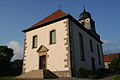
Catholic Church of St. Bonifaz Oberlauter

Evangelical Johanniskirche Neukirchen
Evangelical St. Matthew Church Rottenbach


Sons and daughters of the church
- Johann Schneider (1702–1788), composer, violinist and organist
- Sebastian Straubel (* 1983), politician (CSU), district administrator of the Coburg district
literature
- Walter Eichhorn: Lautertal; The Zent Lauter link between Franconia and Thuringia . Sheets on the history of the Coburg country, Coburg 1992, ISBN 3-926480-06-8 .
Individual evidence
- ↑ "Data 2" sheet, Statistical Report A1200C 202041 Population of the municipalities, districts and administrative districts 1st quarter 2020 (population based on the 2011 census) ( help ).
- ↑ Official topographic map in the BayernAtlas
- ↑ a b c www.gemeindelautertal.de ( Memento of the original from January 22, 2018 in the Internet Archive ) Info: The archive link was inserted automatically and has not yet been checked. Please check the original and archive link according to the instructions and then remove this notice.
- ↑ a b Wilhelm Volkert (Ed.): Handbook of the Bavarian offices, communities and courts 1799–1980 . CH Beck, Munich 1983, ISBN 3-406-09669-7 , p. 441 .
- ↑ a b Federal Statistical Office (ed.): Historical municipality register for the Federal Republic of Germany. Name, border and key number changes in municipalities, counties and administrative districts from May 27, 1970 to December 31, 1982 . W. Kohlhammer GmbH, Stuttgart / Mainz 1983, ISBN 3-17-003263-1 , p. 680 .
- ^ Initiative Stadtmuseum Coburg: 150 years of the Werra Railway ( page no longer available , search in web archives ) Info: The link was automatically marked as defective. Please check the link according to the instructions and then remove this notice. (PDF; 11.1 MB)
- ↑ New construction area stands out from old route. www.infranken.de, February 10, 2012.
- ↑ Result of the municipal council election on March 15, 2020. accessed on April 5, 2020.
Web links
- www.gemeindelautertal.de
- Entry on the coat of arms of Lautertal (Upper Franconia) in the database of the House of Bavarian History
- Lautertal (Upper Franconia): Official statistics of the LfStat (PDF, 1.66 MB)

Maple | Bad Rodach | Dörfles-Esbach | Ebersdorf near Coburg | Great marriage | Grub am Forst | Itzgrund | Lautertal | Meeder | Neustadt bei Coburg | Niederfüllbach | Rödental | Seßlach | Sonnefeld | Untersiemau | Weidhausen near Coburg | Weitramsdorf
Unregulated areas of
Callenberger Forst-West |
Gellnhausen |
Köllnholz