Tremersdorf
|
Tremersdorf
community Lautertal
Coordinates: 50 ° 21 ′ 41 ″ N , 10 ° 56 ′ 45 ″ E
|
|
|---|---|
| Height : | 383 m above sea level NN |
| Area : | 3.07 km² |
| Residents : | 73 (2004) |
| Population density : | 24 inhabitants / km² |
| Incorporation : | 1st January 1969 |
| Incorporated into: | Rottenbach |
| Postal code : | 96486 |
| Area code : | 09566 |
|
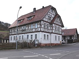
Former inn Zum Eisenhammer
|
|
Tremersdorf is a district of the Upper Franconian community Lautertal in the Coburg district .
location
Tremersdorf is about eleven kilometers north of Coburg at the confluence of the Rottenbach and Weihergraben zur Lauter (also known as Lauterbach). The district road CO 27, formerly federal road 4 , runs through Tremersdorf . Communal roads to Mirsdorf and Görsdorf branch off from the district road.
history
Tremersdorf was first mentioned in a document in 1315. Another documentary mention took place in 1317 in the Urbarium , a listing of possessions of the Henneberger when acquiring the new rule , as "Traymarstorf". The place name indicates a settler named Tragemar or Traimar or Dragomar. The Lords of Haldeck were entrusted by the Counts of Henneberg with Tremersdorf, as well as with the neighboring Neukirchen.
At the beginning of the 14th century, Tremersdorf was under the rule of the Henneberger . In 1353 the place with the Coburg Land came by inheritance to the Wettins and was thus part of the Electorate of Saxony from 1485 , from which the Duchy of Saxony-Coburg later emerged.
The Tremersdorf mill was first mentioned as a fief of the Lords of Coburg in 1423. After the Thirty Years' War only the miller lived in the village. In 1535 Tremersdorf was re-parished from the Meederer Kirchsprengel to Rottenbach .
In 1857 Tremersdorf had 14 school children and 86 residents who lived in 12 houses.
The children attended school in Rottenbach . In 1965, the two-class Rottenbach-Tremersdorf school was relocated to the newly built schoolhouse of the communities Unterlauter and Oberlauter .
In 1914 the Eisenhammer inn was built. In a referendum on November 30, 1919, two citizens of Tremersdorf voted for the Free State of Coburg to join the Thuringian state and 45 against. From July 1, 1920, Tremersdorf also belonged to the Free State of Bavaria . In 1925, the 306.98 hectare village had 83 residents, all of whom belonged to the Evangelical Church, and 13 residential buildings. The school and the Protestant church were in Rottenbach, 2.7 kilometers away.
From 1945 to 1989 the municipal boundary in the east corresponded to the inner German border .
In 1968, in a discussion in the Eisenhammer inn, six citizens voted for Rottenbach, five for Neukirchen and nine abstained. On January 1, 1969, Tremersdorf was incorporated into Rottenbach. On May 1, 1978 Rottenbach was forcibly part of the Lautertal community, which was founded in 1969. In 1987 the village comprised 87 people, 25 residential buildings and 29 apartments.
Population development
|
literature
- Walter Eichhorn: Lautertal; The Zent Lauter link between Franconia and Thuringia . Sheets on the history of the Coburg country, Coburg 1992, ISBN 3-926480-06-8 .
Web links
Individual evidence
- ↑ a b Müller's Large German Local Book 2007. Verlag de Gruyter, ISBN 978-3-00-042206-5 .
- ^ Walter Schneier: The Coburg country. 2nd edition, Coburg 1990. p. 100
- ↑ Horst GRASSMUCK: Place names of the county Coburg. Inaugural dissertation from the University of Erlangen 1955, p. 66.
- ^ Walter Eichhorn: Lautertal. P. 18
- ^ Walter Eichhorn: Lautertal. P. 243
- ↑ a b Walter Eichhorn: Lautertal. P. 259
- ^ Walter Eichhorn: Lautertal. P. 28
- ^ Coburger Zeitung, issue no.280 from December 1, 1919
- ^ Localities directory for the Free State of Bavaria, based on the census of June 16, 1925, Munich, 1928
- ^ Walter Eichhorn: Lautertal. P. 264
- ^ Wilhelm Volkert (ed.): Handbook of Bavarian offices, communities and courts 1799–1980 . CH Beck, Munich 1983, ISBN 3-406-09669-7 , p. 441 .
- ^ Federal Statistical Office (ed.): Historical municipality directory for the Federal Republic of Germany. Name, border and key number changes in municipalities, counties and administrative districts from May 27, 1970 to December 31, 1982 . W. Kohlhammer GmbH, Stuttgart and Mainz 1983, ISBN 3-17-003263-1 , p. 680 .
- ↑ Official directory for Bavaria, territorial status: May 25, 1987, Munich, 1991
- ↑ www.gemeindeververzeichnis.de
- ^ A b Michael Rademacher: German administrative history from the unification of the empire in 1871 to reunification in 1990. City and district of Coburg. (Online material for the dissertation, Osnabrück 2006).

