
Weitramsdorf
| coat of arms | Germany map | |
|---|---|---|

|
Coordinates: 50 ° 15 ' N , 10 ° 53' E |
|
| Basic data | ||
| State : | Bavaria | |
| Administrative region : | Upper Franconia | |
| County : | Coburg | |
| Height : | 300 m above sea level NHN | |
| Area : | 33.72 km 2 | |
| Residents: | 5076 (Dec. 31, 2019) | |
| Population density : | 151 inhabitants per km 2 | |
| Postal code : | 96479 | |
| Primaries : | 09561, 09567 | |
| License plate : | CO, NEC | |
| Community key : | 09 4 73 175 | |
| LOCODE : | DE WT5 | |
| Community structure: | 9 districts | |
| Address of the municipal administration: |
Ummerstadter Str. 11 96479 Weitramsdorf |
|
| Website : | ||
| Mayor : | Andreas Carl (Neundorf village community) | |
| Location of the community of Weitramsdorf in the Coburg district | ||
  |
||

Weitramsdorf is a municipality in the Upper Franconian district of Coburg with around 5100 inhabitants.

geography
location
Weitramsdorf is about five kilometers west of Coburg . The place is surrounded by forests and lies in a side valley of the Rodach .
Community structure
The community of Weitramsdorf consists of the eight districts of Altenhof , Gersbach , Hergramsdorf , Neundorf , Schlettach , Tambach , Weidach and Weitramsdorf. In addition, the place Weidach-Vogelherd, bordering the Coburg district of Scheuerfeld , belongs to the community. Weitramsdorf is the seat of the administration.
history
Until the move to Bavaria
Weitramsdorf was first mentioned in a document in 1177. As part of the Coburg country, the settlement belonged to the Henneberg rulership in the 13th century , which passed to the Wettins in the 14th century . Weitramsdorf was part of Saxony-Coburg until 1920, when it became part of the Free State of Bavaria .
The district Tambach was mentioned as early as 874 as "Tanbah".

Incorporations
Weitramsdorf, Schlettach and Gersbach formed one community from 1869 onwards. On January 1, 1972 Altenhof was incorporated. The former community of Neundorf (previously in the Staffelstein district ) was added on July 1, 1972. Finally, Weidach was incorporated on May 1, 1978.
Population development
In the period from 1988 to 2018, the municipality grew from 4,444 to 5,031 by 587 inhabitants or 13.2%. On December 31, 2006 Weitramsdorf had 5170 inhabitants.
politics
Municipal council
The municipal council has 20 members
- Neundorf village community (DGN): 5 seats
- CSU : 4 seats
- Free voter-citizens' association: 3 seats
- Free voters: 3 seats
- Non-partisan voter group (ÜPWG): 3 seats
- SPD : 2 seats
(Status: 2020)
mayor
- 2002–2014: Christian Gunsenheimer (Free Voters / Citizens' Association)
- 2014–2020: Wolfgang Bauersachs (citizens for citizens)
- since 2020: Andreas Carl (Neundorf village community)
Culture and sights
- St. Nikolaus in Weitramsdorf
- Birth of Mary in Neundorf
- Our Lady of Sorrows in Altenhof
- Tambach Castle
- Tambach Castle Wildlife Park
- Bavarian Falconry
Architectural monuments
economy
The furniture factory Albrecht, founded by Michael Albrecht in 1876 and closed after bankruptcy in 1997, was at times the largest employer in town with over 400 employees. A carpentry company had emerged that produced furniture and interior fittings on an area of over 75,000 square meters. In the Second World War and were gliders manufactured. There were also the Hilmar Franz and Heinz Kräusslich furniture factories. In total, the three companies had well over 700 employees in the 1960s, 1970s and 1980s.
traffic
From Weitramsdorf roads lead to Seßlach , Coburg, Meeder , Bad Rodach and Ummerstadt in Thuringia .

Town hall in Weitramsdorf

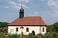
Evangelical Church of St. Nikolaus in Weitramsdorf
Catholic church Mater dolorosa (Virgin Mary Sorrows) in Altenhof

Catholic parish church of the Birth of Mary in Neundorf


dialect
In Weitramsdorf, Itzgründic is spoken as a sub-form of Main Franconian .
Individual evidence
- ↑ "Data 2" sheet, Statistical Report A1200C 202041 Population of the municipalities, districts and administrative districts 1st quarter 2020 (population based on the 2011 census) ( help ).
- ↑ Bayerische Landesbibliothek Online - location database
- ^ Wilhelm Volkert (ed.): Handbook of Bavarian offices, communities and courts 1799–1980 . CH Beck, Munich 1983, ISBN 3-406-09669-7 , p. 442 .
- ^ Federal Statistical Office (ed.): Historical municipality directory for the Federal Republic of Germany. Name, border and key number changes in municipalities, counties and administrative districts from May 27, 1970 to December 31, 1982 . W. Kohlhammer GmbH, Stuttgart / Mainz 1983, ISBN 3-17-003263-1 , p. 680 .
- ↑ Wolfgang Braunschmidt: What will happen to the Albrecht factory? The story of a former furniture manufacturer - a commercial center is to be built on the site . In Neue Presse , August 20, 2009
Web links
- Community website
- Entry on the coat of arms of Weitramsdorf in the database of the House of Bavarian History
- Weitramsdorf: Official statistics of the LfStat (PDF, 1.66 MB)

Maple | Bad Rodach | Dörfles-Esbach | Ebersdorf near Coburg | Great marriage | Grub am Forst | Itzgrund | Lautertal | Meeder | Neustadt bei Coburg | Niederfüllbach | Rödental | Seßlach | Sonnefeld | Untersiemau | Weidhausen near Coburg | Weitramsdorf
Unregulated areas of
Callenberger Forst-West |
Gellnhausen |
Köllnholz
Altenhof | Gersbach | Hergramsdorf | Neundorf | Schlettach | Tambach | Weidach | Weitramsdorf