
Rodach (Itz)
| Rodach | ||
 Spring version of the Rodach |
||
| Data | ||
| Water code | DE : 24166 | |
| location | Germany | |
| River system | Rhine | |
| Drain over | Itz → Main → Rhine → North Sea | |
| source | south of Hildburghausen -Leimrieth 50 ° 24 '18 " N , 10 ° 40' 37" O |
|
| Source height | approx. 405 m above sea level NN | |
| muzzle | west of Itzgrund -Bodelstadt in the Itz coordinates: 50 ° 8 ′ 5 ″ N , 10 ° 52 ′ 37 ″ E 50 ° 8 ′ 5 ″ N , 10 ° 52 ′ 37 ″ E |
|
| Mouth height | approx. 257 m above sea level NN | |
| Height difference | approx. 148 m | |
| Bottom slope | approx. 3.6 ‰ | |
| length | 41.7 km | |
| Catchment area | 386.5 km² | |
| Discharge at the Heinersdorf gauge (97.4% of the catchment area) A Eo : 376 km² Location: 8 km above the mouth |
NNQ (08/18/1976) MNQ 1960–2006 MQ 1960–2006 Mq 1960–2006 MHQ 1960–2006 HHQ (12/24/1967) |
168 l / s 648 l / s 2.51 m³ / s 6.7 l / (s km²) 33.5 m³ / s 73.2 m³ / s |
The Rodach is an almost 42 km long right or northwest tributary of the Itz in Thuringia and Bavaria . Not far away, near Kronach , there is a tributary of the same name to the Main .
course
The Rodach rises south of Hildburghausen - Leimrieth . During her run she changes several times over the Thuringian-Bavarian border between the Heldburger Land and Coburg Land . It flows into the Itz west of Bodelstadt .
- Bridges over the Rodach

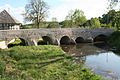
Rodach Bridge in Gauerstadt

Rodach Bridge in Bad Colberg
Rodach Bridge in Ummerstadt

Rodach Bridge in Seßlach


Tributaries
- Nonnengraben (left)
- Schlossergraben (left)
- Weidach (left)
- Peterwiesgraben (right)
- Bachwiesengraben (right)
- Mühlgraben (left)
- Röstengraben (right)
- Oberaugraben (left)
- Stinkgraben (left)
- Central excavation (right)
- Mühlbach (Unterlauf Riethmüllersgraben ) (left)
- Riethgraben (left)
- Breitenauer Graben (left)
- Reinigsgraben (right)
- Tippach (right)
- Böhmgraben (left)
- Foal (en) bach (left)
- Bärsbach (right)
- Schappach (left)
- Fountain raft (right)
- Muschbach (left)
- Sulzbach (left)
- Kreck (river) (right)
- Geiersbach (right)
- Tambach (left)
- Krumbach (left)
- Frog pit (right)
- Mehrenbach (left)
- Brandleitengraben (left)
places
The Rodach flows through the following places:
- Leimrieth
- Stressenhausen
- Steinfeld
- Ice houses
- Adelhausen
- Rossfeld
- Bad Rodach
- Gauerstadt
- Niederndorf
- Billmuthausen - desert and memorial
- Bad Colberg
- Ummerstadt
- Gemünda
- Dietersdorf
- Hattersdorf
- Sesslach
literature
- Johann Kaspar Bundschuh : Rodach . In: Geographical Statistical-Topographical Lexicon of Franconia . tape 4 : Ni-R . Verlag der Stettinische Buchhandlung, Ulm 1801, DNB 790364301 , OCLC 833753101 , Sp. 540 ( digitized version ).
- Norbert Klaus Fuchs: The Heldburger Land - a historical travel guide; Rockstuhl Publishing House, Bad Langensalza 2013, ISBN 978-3-86777-349-2
Web links
Commons : Rodach - collection of pictures, videos and audio files
Individual evidence
- ↑ Map services of the Bavarian State Office for the Environment
- ↑ Flood Action Plan Main
- ^ Deutsches Gewässerkundliches Jahrbuch Rheingebiet, Part II 2006 Bavarian State Office for the Environment, p. 82, accessed on October 4, 2017, at: bestellen.bayern.de (PDF, German, 23.6 MB).