Single mountain
|
Single mountain
municipality Meeder
Coordinates: 50 ° 20 ′ 4 ″ N , 10 ° 55 ′ 30 ″ E
|
|
|---|---|
| Height : | 439 m above sea level NN |
| Residents : | 17 (1987) |
| Postal code : | 96484 |
| Area code : | 09566 |
|
farm
|
|
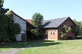
Einzelberg is a district of the Upper Franconian community Meeder in the Coburg district .
geography
Einzelberg is about nine kilometers northwest of Coburg on the southern slope of the Long Mountains on the Hochstraße that connects Ottowind with Moggenbrunn . To the east of Einzelberg lies the federal motorway 73 , where the “Lange Berge” gas station and rest area is to be built.
history
Einzelberg was first mentioned in 1129 as "Etzelsberg".
At the beginning of the 14th century, Einzelberg was under the control of the County of Henneberg . In 1353 the place with the Coburg Land came by inheritance to the Wettins and was thus part of the Electorate of Saxony from 1485 , from which the Duchy of Saxony-Coburg later emerged.
In 1869 it was merged with the neighboring village of Drossenhausen , 0.7 kilometers away .
In 1925, Einzelberg had 34 residents and 4 residential buildings. In 1987 the hamlet had 17 residents and 3 houses. Einzelberg belongs to the Evangelical Lutheran parish of Meeder.
On July 1, 1971, the municipality of Drossenhausen was incorporated into Meeder and Einzelberg was part of this municipality.
Population development
|
Web links
Individual evidence
- ↑ a b c Bavarian State Office for Statistics and Data Processing (Ed.): Official local directory for Bavaria, territorial status: May 25, 1987 . Issue 450 of the articles on Bavaria's statistics. Munich November 1991, DNB 94240937X , p. 299 ( digitized version ).
- ^ Walter Schneier: The Coburg country. 2nd edition, Coburg 1990. p. 86
- ↑ a b Bavarian State Statistical Office (ed.): Localities directory for the Free State of Bavaria according to the census of June 16, 1925 and the territorial status of January 1, 1928 . Issue 109 of the articles on Bavaria's statistics. Munich 1928, Section II, Sp. 1051 ( digitized version ).
- ^ Federal Statistical Office (ed.): Historical municipality directory for the Federal Republic of Germany. Name, border and key number changes in municipalities, counties and administrative districts from May 27, 1970 to December 31, 1982 . W. Kohlhammer, Stuttgart / Mainz 1983, ISBN 3-17-003263-1 , p. 679 f .
- ^ Johann Gerhard Gruner, Johann Ernst von Gruner, Johann Andreas Ortloff: Historical-statistical description of the Principality of Coburg S. Saalfeldische Antheils: With corrective additions, some treatises and a collection of Coburg regional laws, Volume 1, 1793, p. 354
- ↑ Address manual of the Duchy of Saxony-Coburg and Gotha: 1837, p. 83
- ↑ Bavarian State Statistical Office (ed.): Official place directory for Bavaria - edited on the basis of the census of September 13, 1950 . Issue 169 of the articles on Bavaria's statistics. Munich 1952, DNB 453660975 , Section II, Sp. 900 ( digitized version ).
- ^ Bavarian State Statistical Office (ed.): Official place directory for Bavaria . Issue 335 of the articles on Bavaria's statistics. Munich 1973, DNB 740801384 , p. 152 ( digitized version ).
Remarks
- ↑ 1125 after Horst Graßmuck: The place names of the district of Coburg. Inaugural dissertation from the University of Erlangen 1955, p. 20.

