Moggenbrunn
|
Moggenbrunn
municipality Meeder
|
|
|---|---|
| Coordinates: 50 ° 18 ′ 53 ″ N , 10 ° 56 ′ 57 ″ E | |
| Height : | 359 m above sea level NN |
| Area : | 2.74 km² |
| Residents : | 80 (2017) |
| Population density : | 29 inhabitants / km² |
| Incorporation : | April 1, 1971 |
| Postal code : | 96484 |
| Area code : | 09566 |
|
Village square
|
|
Moggenbrunn is a district of the Upper Franconian municipality of Meeder in the Coburg district .
geography
Moggenbrunn is located about five kilometers north of Coburg on the southern foothills of the Long Mountains . Communal roads to Beuerfeld , Drossenhausen , Meeder and Oberlauter lead through the village. Geologically, the bedrock of the Moggenbrunner Flur usually belongs to the shell limestone formation . The soils are mostly loamy and clayey. The soil quality varies greatly.
history
Moggenbrunn was probably created at a spring that was turned into a well. The place was first mentioned in 1317 as "Mackenburne" in the Urbarium , a list of possessions of the Hennebergers when they acquired the New Rulership. Around 1358 the noble family von Kemmaten was mentioned for the first time in a document about Moggenbrunn. The family ruled the village for several centuries and owned the manor with the castle , two farms, a timber district and a sheep farm until 1600 . Moggenbrunn was under the rule of the Henneberger . In 1353 the place with the Coburg Land came by inheritance to the Wettins and was thus part of the Electorate of Saxony from 1485 , from which the Duchy of Saxony-Coburg later emerged. It has belonged to the Evangelical Lutheran parish of Meeder for centuries.
After the Thirty Years War 17% of the goods, 100% of the Selden and 12.5% of the fields were in a "desert" state.
In 1849 the base loads were replaced. The children attended school in Beuerfeld from the 19th century. In the middle of the 19th century a community baking house was built. In 1857, 103 people lived in 16 houses. In 1875 the volunteer fire brigade was founded. In 1907 the community got a telephone connection. In 1909 the existence of the manor ended. Due to high debts, it was broken up by a sale in lots and pieces. In the First World War, lost six and in the Second World War, seven Moggenbrunner soldiers their lives. There are memorial plaques on the cemetery wall in Meeder.
In a referendum on November 30, 1919, a Moggenbrunn citizen voted for the Free State of Coburg to join the Thuringian state and 41 were against. On July 1, 1920, the Free State of Coburg was united with the Free State of Bavaria . From 1922, the electricity supplier was the Coburg overland plant . The local network was transferred to SÜC in 1955 . Land consolidation was carried out between 1932 and 1940 . American troops entered the village on April 10, 1945.
In 1954, the community seal was given a new coat of arms, which was designed based on an old, traditional coat of arms and shows a draw well. The community has been part of the Meeder School Association since 1968 and the pupils take the school bus to Meeder. In the early 1970s, it was connected to the Lautergrund water supply. This was later taken over by Coburg-based SÜC Energie und H2O GmbH. On April 1, 1971, Moggenbrunn became a part of the municipality of Meeder. In 1987 the village had 85 residents and 22 houses.
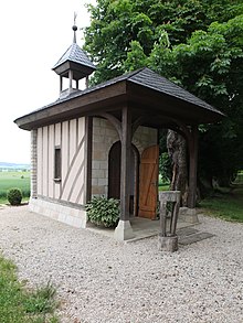
In 1982 the community won the competition “The more beautiful village” in the Coburg district. The first prize, a fountain, was designed by the Nuremberg sculptor Josef Wurm and has been a reminder of the event since 1984. In 1989 Moggenbrunn won the gold medal in the federal decision The more beautiful village . The Eckardt family had the Guardian Angel Chapel built in 2009.
Population development
|
literature
- Eva Herold, Robert Wachter: Moggenbrunn The golden village The farmers and the castle . Meeder 1994.
Web links
Individual evidence
- ↑ a b Neue Presse Coburg, Volume 72, Number 133, Monday, June 12, 2017, p. 15
- ↑ Eva Herold, Robert Wachter: Moggenbrunn The golden village The farmers and the castle p. 19
- ↑ Eva Herold, Robert Wachter: Moggenbrunn The golden village, the farmers and the castle, p. 70
- ^ Coburger Zeitung, issue No. 281 of December 2, 1919
- ^ Wilhelm Volkert (ed.): Handbook of Bavarian offices, communities and courts 1799–1980 . CH Beck, Munich 1983, ISBN 3-406-09669-7 , p. 441 f .
- ↑ Official directory for Bavaria, territorial status: May 25, 1987, Munich, 1991


