Ahlstädt
| coat of arms | Germany map | |
|---|---|---|
 Help on coat of arms |
Coordinates: 50 ° 32 ' N , 10 ° 41' E |
|
| Basic data | ||
| State : | Thuringia | |
| County : | Hildburghausen | |
| Management Community : | Field stone | |
| Height : | 460 m above sea level NHN | |
| Area : | 2.34 km 2 | |
| Residents: | 123 (Dec. 31, 2019) | |
| Population density : | 53 inhabitants per km 2 | |
| Postal code : | 98553 | |
| Area code : | 036873 | |
| License plate : | HBN | |
| Community key : | 16 0 69 001 | |
| LOCODE : | DE AH4 | |
| Association administration address: | Mauerstr. 9 98660 Themar |
|
| Mayoress : | Annette Haupt ( FWG ) | |
| Location of the community of Ahlstädt in the district of Hildburghausen | ||
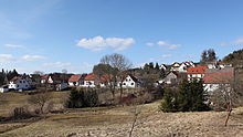
Ahlstädt is a municipality in the Hildburghausen district in the Franconian south of the Free State of Thuringia . It belongs to the administrative community Feldstein , which has its administrative seat in the city of Themar . Ahlstädt is the smallest municipality in the district in terms of inhabitants.
geography
The community is located in the Thuringian Forest Nature Park, approx. 8 km south of Suhl .
history
The place was first mentioned in 1212 as Alstat . Until 1815 Ahlstädt belonged to the Henneberg or Electoral Saxon office of Schleusingen and then came to the Schleusingen district of the newly formed Prussian province of Saxony .
To the north of the village you can still see the vaulted bakeries from the late medieval clearing time of the village, which were painstakingly laid out in the form of a terrace . In the beginning of the 17th century, iron ore mines were built in the vicinity, and it was hoped that mining would provide a new source of income. In 1744 the pits "Unexpected luck" and "Christbescherung" were operated on the Steinberg. A description of the office mentions the Harz scraping as the most important occupation . The resin lumps, which had been laboriously extracted, were supplied to a pitch furnace that had been erected on site and produced around six hundredweight of tree resin (pitch) annually. The remote place had ten houses and 38 residents in 1822. In the 1950s, Ahlstädt received a pig fattening facility on the outskirts, the local farmers had previously joined the LPG. The small town had around 200 inhabitants in the 1960s. In order to alleviate supply problems with basic foodstuffs, a consumer outlet was set up.
politics
The honorary mayor Annette Haupt was elected in June 1999 and re-elected in 2004, 2010 and 2016. Your predecessor was Volker Schamberger.
Municipal council
The municipal council consists of six council members who were elected in the local elections on May 26, 2019 in a majority vote and all belong to the Ahlstädt Free Voting Association.
The turnout was 75.2%.
Culture
The summer solstice bonfire and the fair are held in the community every year.
Individual evidence
- ^ Population of the municipalities from the Thuringian State Office for Statistics ( help on this ).
- ^ Otto Dobencker (arr. And ed.): Regesta diplomatica necnon epistolaria historiae Thuringiae (1210-1227) . tape 2 Part 2. Fischer, Jena 1900. No. 1530
- ^ Herbert Bauer: Suhl . City and country in the Thuringian Forest. Ed .: Council of the district of Suhl. Progress printer, Erfurt 1955, p. 37 .
- ↑ Results of the 2019 local elections in Ahlstädt


