
Beinerstadt
| coat of arms | Germany map | |
|---|---|---|
 Help on coat of arms |
Coordinates: 50 ° 28 ' N , 10 ° 36' E |
|
| Basic data | ||
| State : | Thuringia | |
| County : | Hildburghausen | |
| Management Community : | Field stone | |
| Height : | 423 m above sea level NHN | |
| Area : | 6.71 km 2 | |
| Residents: | 312 (Dec. 31, 2019) | |
| Population density : | 46 inhabitants per km 2 | |
| Postal code : | 98660 | |
| Area code : | 036873 | |
| License plate : | HBN | |
| Community key : | 16 0 69 003 | |
| LOCODE : | DE B6I | |
| Association administration address: | Mauerstr. 9 98660 Themar |
|
| Mayor : | Hans-Werner Büchel ( The Left ) | |
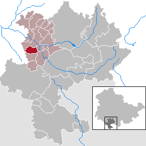
| Location of the municipality of Beinerstadt in the district of Hildburghausen | ||
  |
||

Beinerstadt is a municipality in the district of Hildburghausen in the Franconian south of the Free State of Thuringia . She belongs to the administrative community Feldstein . The administrative seat is in the city of Themar .
geography
The community extends over the St. Bernhard shell limestone plateau with stony and barren soils and lies at an altitude of between 380 and 470 m above sea level. There are 94 hectares of forest in the municipality , mostly mixed forest .

history
Beinerstadt was first mentioned in 796 as Perinheressteti (place of a courtyard ). During the time of the tribal duchies, the place was in the Duchy of Franconia . In terms of lordship, the place in the Themar office initially belonged to the county of Henneberg , after 1583 to various Saxon duchies and from 1826 to 1918 to Saxony-Meiningen . In 1920 he came to the state of Thuringia .
politics
The local council consists of six council members who were elected in the local elections on May 25, 2014 :
| Party / list | Share of votes | G / V | Seats | G / V |
| TSV 1900 Beinerstadt | 51.3% | + 17.9 | 4th | + 2 |
| The left | 28.1% | - 21.8 | 1 | - 2nd |
| Free voters | 20.6% | + 4.0 | 1 | 0 |
P / L: gain or loss compared to the 2009 election
The turnout was 61.1% (- 2.0).
Culture and sights
- The evangelical village church was built as a choir tower church in the Middle Ages and rebuilt in 1750. In 1998 the renovation of the building began with the support of the German Foundation for Monument Protection .
- The Celtic Adventure Trail leads through the community as a supraregional hiking trail.
Individual evidence
- ^ Population of the municipalities from the Thuringian State Office for Statistics ( help on this ).
- ^ Ingrid Scheuermann, Katja Hofmann: Funding projects of the German Foundation for Monument Protection . Ed .: German Foundation for Monument Protection. tape 1 (sacred buildings). Monuments, Bonn 2012, ISBN 3-935208-10-3 , p. 313 .
Web links
Ahlstädt | Floodplain | Beinerstadt | Bischofrod | Brno / Thür. | Thing life | Ehrenberg | Eichenberg | Ice field | Grimmelshausen | Grub | Heldburg | Henfstädt | Hildburghausen | Veßra Monastery | Lengfeld | Marisfeld | Masserberg | Upper Town | Reurieth | Römhild | Bad type | Lock bottom | Schleusingen | Schmeheim | Schweickershausen | St. Bernhard | Straufhain | Themar | Ummerstadt | Veilsdorf | Westhausen