
Floodplain
| coat of arms | Germany map | |
|---|---|---|

|
Coordinates: 50 ° 28 ' N , 10 ° 51' E |
|
| Basic data | ||
| State : | Thuringia | |
| County : | Hildburghausen | |
| Fulfilling municipality : | for Brno / Thür. | |
| Height : | 450 m above sea level NHN | |
| Area : | 37.11 km 2 | |
| Residents: | 2852 (Dec. 31, 2019) | |
| Population density : | 77 inhabitants per km 2 | |
| Postal code : | 98673 | |
| Area code : | 03686 | |
| License plate : | HBN | |
| Community key : | 16 0 69 058 | |
| LOCODE : | DE A7G | |
| Community structure: | 7 districts | |
| Address of the municipal administration: |
Kirchweg 8 98673 Auengrund |
|
| Website : | ||
| Mayor (acting): | Pedro Wallschek (Merbelsrod Fire Brigade Association) | |
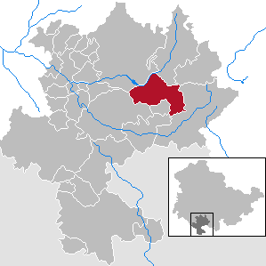
| Location of the community Auengrund in the district of Hildburghausen | ||
  |
||

Auengrund is a municipality in the district of Hildburghausen in the Franconian south of the Free State of Thuringia .
geography
The community is located on the south-western edge of the Thuringian Slate Mountains , where this emerges from the actual Thuringian Forest , between the small towns of Schleusingen (in the northwest) and Eisfeld (in the southwest) and the district town of Hildburghausen in the west. From north to north-east (one after the other) Schleusegrund and Masserberg join.
The municipality of Brünn / Thür belongs to the fulfilling municipality of Auengrund . in the south.
Striking elevations of the community are the Solaberg near Poppenwind (577 m) with its partly cleared secondary peaks Ahornsberg (532 m, near Brattendorf) and Schleusenberg (531 m, near Wiedersbach), the Priemäusel (625 m) near Brattendorf and its northern neighbor, the on the southwest side (on which the district Merbelsrod is located) mostly cleared Wachberg (621 m). The Klingeberg (677 m), which adjoins the Priemäusel to the south-east, is already on the border to the town of Eisfeld or the district of Waffenrod / Hinterrod and is a pre-peak of the even higher Grendel (787 m) and Eselsberg (841.5 m).
Almost all districts are located at altitudes of around 450 m above sea level ; only Wiedersbach lies a little lower at 400 m, Oberwind (490-530 m) and Merbelsrod (520-580 m) on slopes a little higher.
Community structure
The districts of the municipality are:
history

The unified community was formed on January 1, 1996 from three communities united in the Auengrund administrative community .
politics
The mayor of the community is René Pfötsch from WG Vereine Auengrund. He was elected by runoff on June 8, 2014 and received 58.7% of the valid votes. The turnout was 53.4%.
Municipal council
The municipal council in Auengrund consists of 14 elected council members plus the mayor. Since the local elections on May 26, 2019 , it has been composed as follows:
| Party / list | Share of votes | G / V | Seats | G / V |
| WG clubs Auengrund | 28.7% | + 12.7 | 4th | + 1 |
| Fire Brigade Association Merbelsrod | 12.8% | + 0.3 | 2 | ± 0 |
| Citizens' Alliance Auengrund | 17.1% | + 5.0 | 2 | ± 0 |
| Brattendorf home list | 18.1% | + 6.1 | 2 | ± 0 |
| FFW Schwarzbach | 18.4% | + 6.6 | 3 | + 1 |
| Alliance Future Hildburghausen | 4.8% | + 3.4 | 1 | + 1 |
P / L: profit or loss compared to 2014 election
The turnout was 62.3% (+ 0.4).
Compared to the previous legislative period, the municipal council has been reduced by two seats. The parties Die Linke , CDU and the Free Voters did not run again. The right-wing extremist Bündnis-Zukunft-Hildburghausen (BZH) first moved into the local council.
dialect
Itzgründisch , an East Franconian dialect, is spoken in Auengrund .
literature
- Welcome to the unified community of Auengrund: Poppenwind, Schwarzbach, Crock, Wiedersbach, Brattendorf, Merbelsrod, Oberwind (published in cooperation with the sponsor). 2nd Edition. Mering: WEKA-Info-Verlag, 2004.
Individual evidence
- ^ Population of the municipalities from the Thuringian State Office for Statistics ( help on this ).
- ^ Thuringian State Office for Statistics
- ↑ Results of the 2019 municipal council elections in Auengrund
- ↑ Results of the 2014 municipal council elections in Auengrund
Web links
Ahlstädt | Floodplain | Beinerstadt | Bischofrod | Brno / Thür. | Thing life | Ehrenberg | Eichenberg | Ice field | Grimmelshausen | Grub | Heldburg | Henfstädt | Hildburghausen | Veßra Monastery | Lengfeld | Marisfeld | Masserberg | Upper Town | Reurieth | Römhild | Bad type | Lock bottom | Schleusingen | Schmeheim | Schweickershausen | St. Bernhard | Straufhain | Themar | Ummerstadt | Veilsdorf | Westhausen