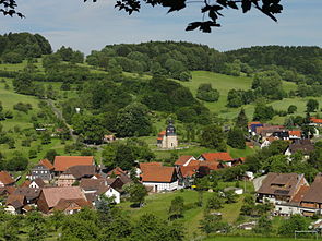
Eichenberg (near Suhl)
| coat of arms | Germany map | |
|---|---|---|
 Help on coat of arms |
Coordinates: 50 ° 33 ' N , 10 ° 40' E |
|
| Basic data | ||
| State : | Thuringia | |
| County : | Hildburghausen | |
| Management Community : | Field stone | |
| Height : | 420 m above sea level NHN | |
| Area : | 4.5 km 2 | |
| Residents: | 165 (Dec. 31, 2019) | |
| Population density : | 37 inhabitants per km 2 | |
| Postal code : | 98553 | |
| Area code : | 036873 | |
| License plate : | HBN | |
| Community key : | 16 0 69 011 | |
| Community structure: | Oberdorf, Unterdorf | |
| Association administration address: | Mauerstr. 9 98660 Themar |
|
| Mayor : | Lutz Röhrig (FwV) | |
| Location of the community Eichenberg in the district of Hildburghausen | ||
Eichenberg is a municipality in the Hildburghausen district in Thuringia. The community belongs to the Feldstein administrative community with its administrative headquarters in the city of Themar .
geography
Eichenberg lies at the transition from the Thuringian Forest to the Werra valley, about 10 kilometers south of Suhl . About two kilometers to the north, the 692-meter-high Schneeberg, the highest mountain in the so-called Little Thuringian Forest, rises .
history
The village was mentioned for the first time in a document dated August 7th, 1130. Eychyneberg was mentioned in a document of the Roman-German Emperor Heinrich V dated August 26th, 1111, but this document must include the So-called Reinhardsbrunner forgeries from a later period can be attributed.
Until 1815, the place belonged to the Henneberg or Electoral Saxon office Schleusingen . From 1815 to 1945 Eichenberg belonged to Prussia and administratively to the Schleusingen district . From 1946 to 1994 Eichenberg belonged to the Suhl-Land district . Since July 1, 1994, the community has been incorporated into the Hildburghausen district.
politics
The council in Eichenberg consists of six council members, who in the local elections in 2014 in a majority vote were elected.
Mayor of the community is Lutz Röhrig. He was elected on February 24, 2019.
Culture and sights
Buildings
On a hill on the west side of the village rises the Protestant church that defines the village . In the center of the village there is a small park with a fountain and a memorial in honor of the Eichenberger who fell in the two world wars.
traffic
Local roads lead from Eichenberg in the direction of Bischofrod , Lengfeld and Grub .
Personalities
- Robert Gladitz (1892–1945), socialist resistance fighter against the Nazi regime
Web links
Individual evidence
- ^ Population of the municipalities from the Thuringian State Office for Statistics ( help on this ).
- ^ Wolfgang Kahl: First mention of Thuringian towns and villages. A manual. Publishing house Rockstuhl, Bad Langensalza, Neuausg. 2005, p. 41
- ^ Dobencker, Otto: Regesta diplomatica necnon epistolaria historiae Thuringiae. Vol. 1: c. 500-1152 No. 1069; Issued in Jena (1896)
- ^ Michael Rademacher: German administrative history from the unification of the empire in 1871 to the reunification in 1990. Schleusingen district. (Online material for the dissertation, Osnabrück 2006).
- ↑ 2014 municipal council election , accessed on May 13, 2019
- ↑ Mayoral election 2019 , accessed on May 13, 2019


