News about the fire
|
News about the fire
Municipality Sonnefeld
Coordinates: 50 ° 13 ′ 3 ″ N , 11 ° 10 ′ 14 ″ E
|
|
|---|---|
| Height : | 331 m above sea level NN |
| Residents : | 153 (Jun. 30, 2018) |
| Incorporation : | July 1, 1971 |
| Postal code : | 96242 |
| Area code : | 09562 |
|
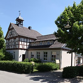
Old school
|
|
Neuses am Brand (officially: Neuses a.Brand ) is a district of the Upper Franconian community of Sonnefeld in the Coburg district .
location
Neuses am Brand is 16 kilometers southeast of Coburg . The place is connected by community roads with Weischau, Mödlitz and Gestungshausen .
history
Neuses am Brand was mentioned as "Nusazi" in the first half of the 11th century. In 1329 the settlement was named "Nevsez".
In 1353 Neuses came to the Wettins by inheritance with the Coburg Land and was thus part of the Electorate of Saxony from 1485 , from which the Duchy of Saxony-Coburg later emerged. In the hereditary book of Sonnefeld monastery from 1514, the whole place was listed as the property of the monastery.
After the death of Duke Albrecht in 1699, Neuses belonged to Sachsen-Hildburghausen as part of the Sonnefeld office in 1705 . In 1826 the office of Sonnefeld came back to Saxony-Coburg in accordance with the Hildburghausen partition agreement . Neuses has belonged to the Evangelical Lutheran parish Gestungshausen for centuries .
In 1837 the village had 110 inhabitants, in 1871 there were 132. In 1879 a joint school with Mödlitz was built in Neuses . In the second half of the 20th century, the students attended the school in Weidhausen.
In a referendum on November 30, 1919, 3 citizens of Neuses voted for the Free State of Coburg to join the Thuringian state and 72 against. Thus from July 1, 1920 Neuses belonged to the Free State of Bavaria . In 1925 the settlement comprised 162.61 hectares, 178 residents and 35 residential buildings.
On May 2, 1971, in a referendum, the majority of 78 people entitled to vote decided in favor of Neuses in the Coburg district and against moving it to Mitwitz in the neighboring Kronach district . On July 1, 1971 the connection to Sonnefeld followed. In 1987 the village comprised 153 people, 39 residential buildings and 54 apartments.
A village renewal took place in 2007.
Population development
|
Web links
Individual evidence
- ↑ http://www.sonnefeld.de/gemeinde-rathaus/gemeinde/zahlen.php
- ↑ Horst GRASSMUCK: Place names of the county Coburg. Inaugural dissertation from the University of Erlangen 1955, p. 49
- ^ Walter Lorenz: Campus Solis. History and property of the former Cistercian abbey of Sonnefeld near Coburg . Verlag Kallmünz, 1955, p. 217
- ↑ Address manual of the Duchy of Saxony-Coburg and Gotha: 1837, p. 84
- ↑ Local directory of the duchies of Coburg and Gotha, compiled on the basis of the census of December 1, 1871, p. 17
- ^ Coburger Zeitung, issue no.280 from December 1, 1919
- ^ Localities directory for the Free State of Bavaria, based on the census of June 16, 1925, Munich, 1928
- ↑ http://www.sonnefeld.de/gemeinde-rathaus/gemeinde/ortsteile.php
- ↑ a b Bavarian State Office for Statistics and Data Processing (Ed.): Official local directory for Bavaria, territorial status: May 25, 1987 . Issue 450 of the articles on Bavaria's statistics. Munich November 1991, DNB 94240937X , p. 300 ( digitized version ).
- ↑ www.gemeindeververzeichnis.de
- ^ A b Michael Rademacher: German administrative history from the unification of the empire in 1871 to reunification in 1990. City and district of Coburg. (Online material for the dissertation, Osnabrück 2006).
- ^ Bavarian State Statistical Office (ed.): Official place directory for Bavaria . Issue 335 of the articles on Bavaria's statistics. Munich 1973, DNB 740801384 , p. 153 ( digitized version ).
