Woerlsdorf
|
Woerlsdorf
Municipality Sonnefeld
Coordinates: 50 ° 15 '55 " N , 11 ° 10' 59" E
|
|
|---|---|
| Height : | 304 m above sea level NN |
| Residents : | 180 (June 30, 2018) |
| Incorporation : | 1st January 1975 |
| Postal code : | 96242 |
| Area code : | 09266 |
|
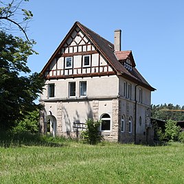
Reception building of the former train station
|
|
Wörlsdorf is a district of the Upper Franconian community of Sonnefeld in the Coburg district .
location
Wörlsdorf is 16 kilometers east of Coburg an der Steinach . The place is crossed by the state road 2708. From this the district road CO 10 branches off to Hassenberg .
history
Wörlsdorf was first mentioned in a document in 1149 as "Wernhersdorf". The Würzburg Bishop Siegfried von Truhendingen confirmed that the newly founded Mönchröden Monastery had also been given the settlement by Hermann Sterker , Burgrave of Meißen and his brother, Count Sterker. The place name contains the personal name Wernher as a defining word.
In 1783 the place had 68 inhabitants and 14 houses, in 1857 there were 89 inhabitants and 16 houses.
In 1864 the volunteer fire brigade in Wörlsdorf was founded. In a referendum on November 30, 1919, 7 citizens of Wörlsdorf voted for the Free State of Coburg to join the Thuringian state and 21 against. From July 1, 1920, Wörlsdorf also belonged to the Free State of Bavaria . In 1920 Wörlsdorf got a connection to the railway network with the Steinachtalbahn . In 1989 the line was closed. In the period from 1945 to 1989, the location on the inner-German border was decisive for the place . In 1950 Wörlsdorf was spun off from the Fechheimer Kirchsprengel and parish into the new independent parish of the Evangelical Lutheran Church in Hassenberg.
On April 8, 1973, in a referendum, 124 of 209 voters decided to keep Hassenberg in the Coburg district and 83 to move to the neighboring Kronach district in Mitwitz , with 2 invalid votes. At the municipal council meeting in early December 1974, the connection to Sonnefeld was decided on January 1, 1975. The primary school students attend the elementary school in Mitwitz.
Population development
|
Architectural monuments
→ List of architectural monuments in Wörlsdorf
Web links
Individual evidence
- ↑ http://www.sonnefeld.de/gemeinde-rathaus/gemeinde/zahlen.php
- ↑ Horst GRASSMUCK: Place names of the county Coburg. Inaugural dissertation from the University of Erlangen 1955, p. 76
- ↑ Thomas Gunzelmann: Hassenberg - an example of knighthood Peuplierung in the Coburg country . In: Yearbook of the Coburg State Foundation 1990 , p. 279 f
- ↑ http://www.infranken.de/regional/coburg/Bereit-zum-Kampf-gegen-das-Feuer;art214,765554
- ^ Coburger Zeitung, issue no.280 from December 1, 1919
- ↑ http://www.sonnefeld.de/gemeinde-rathaus/gemeinde/ortsteile.php
- ↑ www.gemeindeververzeichnis.de
- ^ A b Michael Rademacher: German administrative history from the unification of the empire in 1871 to reunification in 1990. City and district of Coburg. (Online material for the dissertation, Osnabrück 2006).
