Taimbach
|
Taimbach
City of Rödental
Coordinates: 50 ° 19 ′ 47 " N , 10 ° 59 ′ 47" E
|
|
|---|---|
| Height : | 425 m above sea level NN |
| Residents : | 0 (2014) |
| Incorporation : | April 1, 1928 |
| Incorporated into: | Fornbach |
|
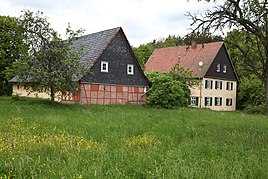
Forester's house
|
|
Taimbach is a forester's house and part of the municipality of Rödental in the Taimbach Forest.
The settlement was first mentioned in 1459 as "Dammbech".
The ducal forest office branch Taimbach was merged with the forest districts Neukirchen and Oberwohlsbach after 1840 . The forestry also operated agriculture and had fish ponds and gardens. Until 1806 it belonged to the Office of Coburg and Lauter Court .
On April 1, 1928, the Taimbach was incorporated into Fornbach . Until then, the place was assigned to the Unterlauter school and church district .
Taimbach had 15 inhabitants in 1856, 10 in 1910 and 4 in 1970. On October 1, 1966, the forest office branch was closed. Today the community part is uninhabited.
Web links
Commons : Taimbach - Collection of images, videos and audio files
Individual evidence
- ↑ Horst GRASSMUCK: Place names of the county Coburg. Inaugural dissertation from the University of Erlangen 1955, p. 64
- ^ Walter Eichhorn: Lautertal; The Zent Lauter link between Franconia and Thuringia . Sheets on the history of the Coburg country, Coburg 1992, ISBN 3-926480-06-8 . P. 43
- ^ Wilhelm Volkert (ed.): Handbook of Bavarian offices, communities and courts 1799–1980 . CH Beck, Munich 1983, ISBN 3-406-09669-7 , p. 441 .
- ^ Walter Eichhorn: Lautertal . P. 156
- ↑ www.gemeindeververzeichnis.de
- ↑ Census of May 27, 1970
