Schneckenlohe
| coat of arms | Germany map | |
|---|---|---|

|
Coordinates: 50 ° 13 ' N , 11 ° 12' E |
|
| Basic data | ||
| State : | Bavaria | |
| Administrative region : | Upper Franconia | |
| County : | Kronach | |
| Management Community : | Mitwitz | |
| Height : | 326 m above sea level NHN | |
| Area : | 9.31 km 2 | |
| Residents: | 1031 (Dec. 31, 2019) | |
| Population density : | 111 inhabitants per km 2 | |
| Postal code : | 96277 | |
| Area code : | 09266 | |
| License plate : | KC, SAN | |
| Community key : | 09 4 76 171 | |
| Community structure: | 4 districts | |
| Address of the municipal administration: |
Henneschberg 20 96277 Schneckenlohe |
|
| Website : | ||
| Mayor : | Knut Morgenroth ( SPD ) | |
| Location of the community Schneckenlohe in the district of Kronach | ||
Schneckenlohe is a municipality in the Upper Franconian district of Kronach in Bavaria . She is a member of the Mitwitz administrative community .
geography
Geographical location
The municipality is located to the southwest of the Franconian line and is part of the Upper Main hill country . The Steinach runs through it in a north-south direction .
Districts
Neighboring communities
clockwise from north:
- Mitwitz
- Küps
- Redwitz an der Rodach ( Lichtenfels district )
- Marktgraitz ( Lichtenfels district )
- Weidhausen near Coburg ( Coburg district )
- Sonnefeld ( district of Coburg )
history
Schneckenlohe was first mentioned in a document in 1323. In the early Middle Ages, the rulers of the village alternately owned the Lords of Redwitz and the bishopric of Bamberg . 1520 the von Redwitz introduced the Reformation . The village was at times desolate. Resettlement began in 1700. In 1840 Schneckenlohe had 51 houses with 256 inhabitants, who were mainly working from home in the basket weaving.
In 1862 the rural community Schneckenlohe, consisting of the village Schneckenlohe, was incorporated into the newly created Bavarian district office of Kronach . In 1871 the village had 455 inhabitants, of whom 178 were Catholic and 277 were Protestant, and 70 residential buildings. Schneckenlohe belonged to the Catholic parish in Graitz , 3.5 kilometers away , where the Catholic denominational school was also located, and to the Protestant parish in Schmölz, 5.3 kilometers away . A school building was built in 1894 by the political community in 1894 for the Protestant pupils who previously had to walk to the Beikheim school, and a year later by the parish of Marktgraitz for the Catholic pupils. In 1900, 473 people lived in 81 residential buildings. In 1925, 500 people, 167 Catholics and 333 Lutherans lived in the village in 93 residential buildings. In 1950 the 61.04 hectare village had 676 residents and 102 residential buildings. In 1970 the village of Schneckenlohe had 713 inhabitants and in 1987 686 inhabitants and 181 residential buildings with 238 apartments. The community Schneckenlohe had 1168 inhabitants.
In September 1959, the Catholic branch church St. Otto in the village of Schneckenlohe was consecrated by the Bamberg prelate Heinrich Rauh. The Evangelical Lutheran Church, the Martin Luther Community Center, was inaugurated in 1971. The belated bell tower with four bells followed in 1977.
Incorporations
On January 1, 1977 the village of Neubrand, part of the Marktgraitz market, was incorporated into Schneckenlohe. The reclassification of Mödlitz, part of the neighboring community Weidhausen bei Coburg since January 1, 1972 , and the incorporation of the Beikheim community to Schneckenlohe followed on May 1, 1978.
Population development
In the period from 1988 to 2018, the population fell from 1,165 to 1,028 by 137 inhabitants or 11.8%. On December 31, 1999, Schneckenlohe had 1,208 inhabitants.
politics
mayor
Mayor has been Knut Morgenroth (SPD) since 2008. The predecessor was Erwin Horn (CSU).
Municipal council
The local elections in 2002, 2008 and 2014 led to the following allocation of seats in the local council:
| 2002 | 2008 | 2014 | |
|---|---|---|---|
| CSU | 5 | 5 | 5 |
| SPD | 4th | 4th | 5 |
| Village community | 3 | 3 | 2 |
| total | 12 seats | 12 seats | 12 seats |
coat of arms
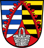
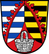
| Blazon : “Split by a lowered red tip with a silver handle inside; Front seven times divided by blue and silver, covered with an oblique, curved red diamond wreath , behind seven times divided by gold and black, covered with an inclined, curved red diamond wreath. " | |
Partnerships
Schneckenlohe maintains a partnership with the Italian Borghetto di Vara in Liguria .
Architectural monuments
Individual evidence
- ↑ "Data 2" sheet, Statistical Report A1200C 202041 Population of the municipalities, districts and administrative districts 1st quarter 2020 (population based on the 2011 census) ( help ).
- ↑ a b Schneckenlohe.de: History
- ↑ Kgl. Statistical Bureau (ed.): Complete list of localities of the Kingdom of Bavaria. According to districts, administrative districts, court districts and municipalities, including parish, school and post office affiliation ... with an alphabetical general register containing the population according to the results of the census of December 1, 1875 . Adolf Ackermann, Munich 1877, 2nd section (population figures from 1871, cattle figures from 1873), Sp. 1062 , urn : nbn: de: bvb: 12-bsb00052489-4 ( digital copy ).
- ↑ K. Bayer. Statistical Bureau (Ed.): Directory of localities of the Kingdom of Bavaria, with alphabetical register of places . LXV. Issue of the contributions to the statistics of the Kingdom of Bavaria. Munich 1904, Section II, Sp. 1058 ( digitized version ).
- ↑ Bavarian State Statistical Office (ed.): Localities directory for the Free State of Bavaria according to the census of June 16, 1925 and the territorial status of January 1, 1928 . Issue 109 of the articles on Bavaria's statistics. Munich 1928, Section II, Sp. 1092 ( digitized version ).
- ↑ Bavarian State Statistical Office (ed.): Official place directory for Bavaria - edited on the basis of the census of September 13, 1950 . Issue 169 of the articles on Bavaria's statistics. Munich 1952, DNB 453660975 , Section II, Sp. 942 ( digitized version ).
- ^ Bavarian State Statistical Office (ed.): Official place directory for Bavaria . Issue 335 of the articles on Bavaria's statistics. Munich 1973, DNB 740801384 , p. 159 ( digitized version ).
- ↑ Bavarian State Office for Statistics and Data Processing (Ed.): Official local directory for Bavaria, territorial status: May 25, 1987 . Issue 450 of the articles on Bavaria's statistics. Munich November 1991, DNB 94240937X , p. 311 ( digitized version ).
- ^ Federal Statistical Office (ed.): Historical municipality directory for the Federal Republic of Germany. Name, border and key number changes in municipalities, counties and administrative districts from May 27, 1970 to December 31, 1982 . W. Kohlhammer GmbH, Stuttgart / Mainz 1983, ISBN 3-17-003263-1 , p. 690 and 691 .
- ↑ Entry on the coat of arms of Schneckenlohe in the database of the House of Bavarian History
Web links
- Website of the community
- Schneckenlohe: Official statistics of the LfStat (PDF; 1.66 MB)


