Beikheim
|
Beikheim
community Schneckenlohe
Coordinates: 50 ° 12 ′ 42 ″ N , 11 ° 13 ′ 24 ″ E
|
|
|---|---|
| Height : | 289 m above sea level NHN |
| Area : | 3.46 km² |
| Residents : | 271 (1987) |
| Population density : | 78 inhabitants / km² |
| Incorporation : | May 1, 1978 |
| Postal code : | 96277 |
| Area code : | 09266 |
|
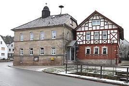
Old school house
|
|
Beikheim is a district of the Upper Franconian community Schneckenlohe in the Kronach district in Bavaria .
geography
The village lies between Coburg and Kronach an der Steinach in the Upper Main hill country . The Steinach valley narrows before Beikeim between the Gubel mountain and the slopes of the Leutendorfer forest. The Krebsbach and the Vierlitzenbach flow through Beikheim and flow into the Steinach as left tributaries. The state road 2208 connects the place with Mitwitz and Redwitz an der Rodach and the district road KC 29 with Schneckenlohe. The federal highway 303 leads past the place on the approximately 230 meter long Steinachtal bridge.
history
Beikheim was first mentioned in 1348 as "Beykhawe". The place name is of Slavic origin. In the Middle Ages, the von Redwitz family owned the village. In 1520 the Reformation was introduced. In 1840 Beikheim had 253 inhabitants who worked in agriculture.
Beikheim came to the Electorate of Bavaria in 1803 , later the Kingdom of Bavaria . In the north the place borders on Leutendorf , which was part of Saxony-Coburg .
In 1862 the rural community of Beikheim was incorporated into the newly created Bavarian district office of Kronach . The remote area of Fahlenberg on the Kellerberg , which was abandoned at the end of the 19th century, belonged to the community. In 1871 the village had 265 residents and 40 residential buildings. An evangelical denominational school was located in the village. The students from the neighboring communities Schneckenlohe, Trainau and Mannsgereuth also visited these . In 1900, 277 people lived in 41 residential buildings, of whom 269 were Protestants and 8 were Catholics. Beikheim belonged to the evangelical parish in Schmölz, 3 miles away . In 1925, 244 people, 3 Catholics and 241 Lutherans lived in the village in 43 residential buildings. In 1936 a cemetery was created. In 1950 the 345.55 hectare village had 384 residents and 44 residential buildings. The Catholics belonged to the Catholic parish of Theisenort, 5.0 kilometers away . In 1970 Beikheim had 277 residents and in 1987 271 residents and 68 residential buildings with 89 apartments.
On May 1, 1978 Beikheim was incorporated into Schneckenlohe.
Web links
Individual evidence
- ↑ a b Bavarian State Office for Statistics and Data Processing (Ed.): Official local directory for Bavaria, territorial status: May 25, 1987 . Issue 450 of the articles on Bavaria's statistics. Munich November 1991, DNB 94240937X , p. 311 ( digitized version ).
- ↑ a b Schneckenlohe.de: History
- ↑ Kgl. Statistical Bureau (ed.): Complete list of localities of the Kingdom of Bavaria. According to districts, administrative districts, court districts and municipalities, including parish, school and post office affiliation ... with an alphabetical general register containing the population according to the results of the census of December 1, 1875 . Adolf Ackermann, Munich 1877, 2nd section (population figures from 1871, cattle figures from 1873), Sp. 1057 , urn : nbn: de: bvb: 12-bsb00052489-4 ( digitized version ).
- ↑ K. Bayer. Statistical Bureau (Ed.): Directory of localities of the Kingdom of Bavaria, with alphabetical register of places . LXV. Issue of the contributions to the statistics of the Kingdom of Bavaria. Munich 1904, Section II, Sp. 1051 ( digitized version ).
- ↑ Bavarian State Statistical Office (ed.): Localities directory for the Free State of Bavaria according to the census of June 16, 1925 and the territorial status of January 1, 1928 . Issue 109 of the articles on Bavaria's statistics. Munich 1928, Section II, Sp. 1085 ( digitized version ).
- ↑ Bavarian State Statistical Office (ed.): Official place directory for Bavaria - edited on the basis of the census of September 13, 1950 . Issue 169 of the articles on Bavaria's statistics. Munich 1952, DNB 453660975 , Section II, Sp. 934 ( digitized version ).
- ^ Bavarian State Statistical Office (ed.): Official place directory for Bavaria . Issue 335 of the articles on Bavaria's statistics. Munich 1973, DNB 740801384 , p. 158 ( digitized version ).

