
Reichenbach (District of Kronach)
| coat of arms | Germany map | |
|---|---|---|

|
Coordinates: 50 ° 26 ' N , 11 ° 25' E |
|
| Basic data | ||
| State : | Bavaria | |
| Administrative region : | Upper Franconia | |
| County : | Kronach | |
| Management Community : | Teuschnitz | |
| Height : | 610 m above sea level NHN | |
| Area : | 8.65 km 2 | |
| Residents: | 657 (Dec. 31, 2019) | |
| Population density : | 76 inhabitants per km 2 | |
| Postal code : | 96358 | |
| Area code : | 09268 | |
| License plate : | KC, SAN | |
| Community key : | 09 4 76 166 | |
| Address of the municipal administration: |
Main street 32 96358 Reichenbach |
|
| Website : | ||
| First Mayor: | Karin Ritter ( SPD ) | |
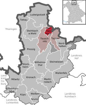
| Location of the community of Reichenbach in the district of Kronach | ||
  |
||

_-_Feldkapelle.jpg)
Reichenbach is a municipality in the Upper Franconian district of Kronach in Bavaria . She is a member of the Teuschnitz administrative community .
Geographical location
Reichenbach is located in the Franconian Forest Nature Park . The Franconian Marienweg runs through the village .
history
In 1190 Reichenbach was first mentioned as "Richebach".
In 1862 the rural community of Reichenbach was incorporated into the newly created Bavarian district office of Teuschnitz . The village belonged to the Ludwigsstadt district court and had 433 inhabitants in 1871. A Catholic denominational school was in the place. In 1950 Reichenbach had 1160 inhabitants and in 1987 966 inhabitants. 30 years later, the number had dropped to 671.
The parish church of St. Michael was built from 1974 to 1975. The church was consecrated on September 18, 1977 by the Archbishop of Bamberg, Elmar Maria Kredel . On July 18, 1978 Reichenbach was appointed parish church of the parish of Haßlach near Teuschnitz.
Population development
Between 1988 and 2018 the population fell from 956 to 667 by 289 or by 30.2%; third largest population loss in percent in Bavaria in the period mentioned.
politics
Municipal council
The municipal council has eight members. There is also the honorary mayor.
| CSU | SPD | Citizens Register Reichenbach (BLR) | total | |
|---|---|---|---|---|
| 2002 | 3 | 5 | 0 | 8 seats |
| 2008 | 5 | 3 | 0 | 8 seats |
| 2014 | 2 | 4th | 2 | 8 seats |
mayor
Karin Ritter (SPD) has been the mayor since May 1, 2008. The predecessor was Roland Schnappauf (CSU).
coat of arms
Description of the coat of arms : "In blue a growing, left-turning, golden crook, the curvature ending in a clover leaf, topped with a slanted crossed golden miner's hammer and a golden slateer's hammer as well as a lowered silver wavy bar."
Architectural monuments
Individual evidence
- ↑ "Data 2" sheet, Statistical Report A1200C 202041 Population of the municipalities, districts and administrative districts 1st quarter 2020 (population based on the 2011 census) ( help ).
- ↑ habenbach-kronach.de : Geschichte
- ↑ Kgl. Statistical Bureau (ed.): Complete list of localities of the Kingdom of Bavaria. According to districts, administrative districts, court districts and municipalities, including parish, school and post office affiliation ... with an alphabetical general register containing the population according to the results of the census of December 1, 1875 . Adolf Ackermann, Munich 1877, 2nd section (population figures from 1871, cattle figures from 1873), Sp. 1126 , urn : nbn: de: bvb: 12-bsb00052489-4 ( digitized version ).
- ↑ Bavarian State Statistical Office (ed.): Official place directory for Bavaria - edited on the basis of the census of September 13, 1950 . Issue 169 of the articles on Bavaria's statistics. Munich 1952, DNB 453660975 , Section II, Sp. 941 ( digitized version ).
- ↑ Bavarian State Office for Statistics and Data Processing (Ed.): Official local directory for Bavaria, territorial status: May 25, 1987 . Issue 450 of the articles on Bavaria's statistics. Munich November 1991, DNB 94240937X , p. 311 ( digitized version ).
Web links
- Entry on the coat of arms of Reichenbach (district of Kronach) in the database of the House of Bavarian History
- Internet presence of Reichenbach (Upper Franconia)
- Reichenbach (District of Kronach): Official statistics of the LfStat (PDF; 1.45 MB)

Kronach | Küps | Ludwigsstadt | Marktrodach | Mitwitz | Nordhalben | Pressy | Reichenbach | Schneckenlohe | Steinbach am Wald | Stone meadows | Stockheim | Tettau | Teuschnitz | Tschirn | Wallenfels | Weißenbrunn | Wilhelmsthal
Unparished areas: Birnbaum | Langenbach Forest