
Administrative community Teuschnitz
| coat of arms | Germany map | |
|---|---|---|
 Help on coat of arms |
Coordinates: 50 ° 23 ' N , 11 ° 23' E |
|
| Basic data | ||
| State : | Bavaria | |
| Administrative region : | Upper Franconia | |
| County : | Kronach | |
| Area : | 63.03 km 2 | |
| Residents: | 3156 (Dec. 31, 2019) | |
| Population density : | 50 inhabitants per km 2 | |
| License plate : | KC, SAN | |
| Association key : | 09 4 76 5433 | |
| Association structure: | 3 municipalities | |
| Association administration address : |
Main street 38 96358 Teuschnitz |
|
| Website : | ||
| Chairman : | Gabriele Weber | |
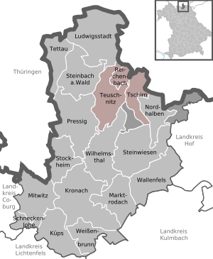
| Location of the Teuschnitz administrative community in the Kronach district | ||
  |
||

In the administrative community of Teuschnitz in the Upper Franconian district of Kronach , the following municipalities joined forces on May 1, 1978 to handle their administrative business:
- Reichenbach , 657 inhabitants, 8.65 km²
- Teuschnitz , town with 1973 inhabitants, 34.26 km²
- Tschirn , 526 inhabitants, 20.12 km²
The seat of the administrative community is the city of Teuschnitz.
Individual evidence
- ↑ "Data 2" sheet, Statistical Report A1200C 202041 Population of the municipalities, districts and administrative districts 1st quarter 2020 (population based on the 2011 census) ( help ).