Wonsees
| coat of arms | Germany map | |
|---|---|---|

|
Coordinates: 49 ° 58 ' N , 11 ° 18' E |
|
| Basic data | ||
| State : | Bavaria | |
| Administrative region : | Upper Franconia | |
| County : | Kulmbach | |
| Management Community : | Kasendorf | |
| Height : | 431 m above sea level NHN | |
| Area : | 36.79 km 2 | |
| Residents: | 1168 (Dec. 31, 2019) | |
| Population density : | 32 inhabitants per km 2 | |
| Postal code : | 96197 | |
| Area code : | 09274 | |
| License plate : | KU, EBS , SAN | |
| Community key : | 09 4 77 164 | |
| Market structure: | 11 districts | |
Market administration address : |
Marktplatz 4 96197 Wonsees |
|
| Website : | ||
| Mayor : | Andreas Pöhner ( non-partisan voter community ) | |
| Location of the Wonsees market in the district of Kulmbach | ||
Wonsees is a market in the district of Kulmbach ( Upper Franconia administrative district ) and a member of the Kasendorf administrative community .
geography
The place is near the federal highway 70 (junction 21 Schirradorf). The Franconian Marienweg runs through Wonsees .
Community structure
Wonsees consists of a total of eleven districts:
|
history
Until the church is planted
In 1323 Wonsees was raised to market. The former office of the Prussian Principality of Bayreuth since 1792 belonged to the Franconian Empire since 1500 . With this it fell to France in the Peace of Tilsit in 1807 and came to Bavaria in 1810. In the course of the administrative reforms in Bavaria , today's municipality was created with the municipal edict of 1818 . Until June 30, 1972 Wonsees belonged to the disbanded district of Ebermannstadt .
Territorial reform
On January 1, 1971, Kainach was incorporated, but was removed again in the course of the first half of 1972. On July 1, 1972, Sanspareil was added. Schirradorf followed on May 1, 1978.
Population development
In the period from 1988 to 2018, the market grew from 1,065 to 1,147 by 82 inhabitants or 7.7%. On December 31, 2003, Wonsees had 1,202 residents.
Market council
The market community council has 15 members including Mayor Andreas Pöhner (non-partisan voter community). All members belong to the non-partisan voter community. (As of: local elections on March 16, 2014)
Culture and sights
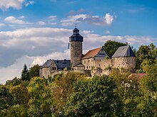
- Zwernitz Castle , the former ancestral seat of the Franconian Walpots , was owned by the Hohenzollern from 1338 to 1810 .
- Directly below the castle is the Sanspareil rock garden with bizarre rock formations and the oriental building.
- Evangelical parish church, formerly St. Laurentius, with a late Gothic tower and ossuary from the 16th century. The nave was built between 1725 and 1729. The church contains a remarkable pulpit altar and baptismal angel by Johann Caspar Fischer, a student of Elias Räntz .
Architectural monuments
Sons and daughters of the church
- Friedrich Taubmann (* 1565 in Wonsees, † 1613 in Wittenberg), imperially crowned poet and famous classical philologist
literature
- Johann Kaspar Bundschuh : Wonsees . In: Geographical Statistical-Topographical Lexicon of Franconia . tape 6 : V-Z . Verlag der Stettinische Buchhandlung, Ulm 1804, DNB 790364328 , OCLC 833753116 , Sp. 193 ( digitized version ).
- Johann Kaspar Bundschuh : Wonsees . In: Geographical Statistical-Topographical Lexicon of Franconia . tape 6 : V-Z . Verlag der Stettinische Buchhandlung, Ulm 1804, DNB 790364328 , OCLC 833753116 , Sp. 966 ( digitized version ).
- Pleikard Joseph Stumpf : Wonsees . In: Bavaria: a geographical-statistical-historical handbook of the kingdom; for the Bavarian people . Second part. Munich 1853, p. 597 ( digitized version ).
Web links
- Homepage of the market town of Wonsees
- Homepage of the parish Wonsees
- Homepage of the parish church of St. Laurentius
- Entry on the Wonsees coat of arms in the database of the House of Bavarian History , accessed on | localtime | YYYY-MM-DD | .
Individual evidence
- ↑ "Data 2" sheet, Statistical Report A1200C 202041 Population of the municipalities, districts and administrative districts 1st quarter 2020 (population based on the 2011 census) ( help ).
- ↑ http://www.bayerische-landesbibliothek-online.de/orte/ortssuche_action.html ? Anzeige=voll&modus=automat&tempus=+20111031/185512&attr=OBJ&val= 1286
- ^ Wilhelm Volkert (ed.): Handbook of Bavarian offices, communities and courts 1799–1980 . CH Beck, Munich 1983, ISBN 3-406-09669-7 , p. 452 .
- ^ Federal Statistical Office (ed.): Historical municipality directory for the Federal Republic of Germany. Name, border and key number changes in municipalities, counties and administrative districts from May 27, 1970 to December 31, 1982 . W. Kohlhammer GmbH, Stuttgart / Mainz 1983, ISBN 3-17-003263-1 , p. 693 .


