
Earl mate
| coat of arms | Germany map | |
|---|---|---|

|
Coordinates: 50 ° 12 ' N , 11 ° 36' E |
|
| Basic data | ||
| State : | Bavaria | |
| Administrative region : | Upper Franconia | |
| County : | Kulmbach | |
| Management Community : | Marktleugast | |
| Height : | 570 m above sea level NHN | |
| Area : | 20.81 km 2 | |
| Residents: | 869 (Dec. 31, 2019) | |
| Population density : | 42 inhabitants per km 2 | |
| Postal code : | 95356 | |
| Area code : | 09255 | |
| License plate : | KU, EBS , SAN | |
| Community key : | 09 4 77 117 | |
| LOCODE : | DE GGA | |
| Market structure: | 28 districts | |
Market administration address : |
Main street 19 95356 Grafengehaig |
|
| Website : | ||
| Mayor : | Werner Burger ( village community / regional voter community ) | |
| Location of the Grafengehaig market in the district of Kulmbach | ||
  |
||

Grafengehaig is a market in the Upper Franconian district of Kulmbach .
geography
Geographical location
Grafengehaig is located on the western slope of the quarry mountain in the Franconian Forest Nature Park , surrounded by deep valleys at an altitude of 568 to approx. 700 meters above sea level. The valleys correspond to the asymmetrical valley shapes of the southwestern Franconian forest, that is, the southern slopes are flatter than the northern slopes, a consequence of geomorphological processes since the last ice age. Remains of terracing are suspected in the Steinach valley area.
Viewpoints
The viewing rock is located above Grafengehaig at 646 m above sea level. NN between the Hohenreuther settlement and the Steinbruchberg ( 688.1 m above sea level ). The 400 meter long ascent is signposted from the Hohenreuther settlement in Grafengehaig. At the top there is a view of the Steinach Valley, the heights of the Franconian Forest and the Fichtel Mountains.
Near the village of Grafengehaig is the highest mountain in the Franconian Forest, the Döbraberg ( 794.6 m above sea level , about eight kilometers away), with its tower as a lookout point.

Lookout rock, facing southeast
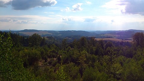
Lookout rock, facing southwest


Community structure
The municipality of Grafengehaig has 28 districts:
Adjacent communities
Guttenberg , Helmbrechts , Marktleugast , Presseck , Stadtsteinach .
history


Until the 19th century
Grafengehaig's historical beginnings can be traced back to the time around the turn of the first millennium . It was first mentioned in a backdated contract of the Counts of Henneberg from 1017. However, the authenticity of the contract is disputed, so a document from 1318 is far more important. With this, the "castrum Wildenstein" with its associated villages was sold by Bamberg Bishop Wulving von Stubenberg to Nikolaus von der Grün.
In 1455 a Veit von Wildenstein was named, the founder of an early mass, possibly in connection with a benefice . Both of these factors probably led to the parish becoming a chaplain . During this time, the Lords of Guttenberg and their landholders were also mentioned, at least for the lower local area. From 1585 both sexes exercised a Compatronat. After the Thirty Years' War , the Wildenstein family perished in 1632, whereby the patronage passed to the bishops of Bamberg. After a short time it came to the Barons Voit von Rieneck , based in Heinersreuth. The barons of Guttenberg also had scattered rights in the wider municipality . In 1803 the seat of power in Heinersreuth was occupied by the Bavarians and Grafengehaig came to Bavaria .
Incorporations
On January 1, 1972, the large community Grafengehaig was formed, the previously independent communities Eppenreuth, Grünlas, Horbach, Rappetenreuth, Schlockenau, Walberngrün and Weidmes were incorporated.
Population development
In the period from 1988 to 2018, the population fell from 1,061 to 879 by 182 or 17.2%. On December 31, 1992 the market had 1123 inhabitants.
| Population development | ||||||||||
|---|---|---|---|---|---|---|---|---|---|---|
| year | 1950 | 1961 | 1970 | 1987 | 1991 | 1995 | 2002 | 2005 | 2010 | 2015 |
| Residents | 1935 | 1589 | 1431 | 1109 | 1093 | 1119 | 1075 | 1018 | 958 | 887 |
Religions
In the 16th and 17th centuries the Bamberg prince-bishops tried very hard to recatholize the Protestant town. From 1625 to 1631 a priest was installed in the knightly place for this purpose, but had to give way under the pressure of the evangelical party, which grew stronger in the Swedish turn of the war in 1631/1632. After the war, on the basis of the normal annual rule of the Peace of Westphalia, the parish could again be freely and continuously occupied by Protestant clergy.
The majority of the population of Grafengehaig is now Protestant-Lutheran. The parish includes the town of Gösmes and the Protestant population from Buckenreuth , Hohenberg , Neuensorg and Traindorf beyond the political parish boundary .
politics
The community is a member of the Marktleugast administrative community .
Municipal council

The local elections in 2002, 2008 and 2014 led to the following allocation of seats in the municipal council:
| Voter group | 2002 | 2008 | 2014 |
|---|---|---|---|
| Village community / supra-local voter community | 5 seats | 4 seats | 5 seats |
| Eppenreuth-Schlockenau voter community | 3 seats | 3 seats | 3 seats |
| Mühlweg voter group | 2 seats | 3 seats | 3 seats |
| United Weidmes Community of Voters | 1 seat | 1 seat | ------ |
| Free voter community Horbach-Grünlas | 1 seat | 1 seat | 1 seat |
| total | 12 seats | 12 seats | 12 seats |
mayor
Werner Burger (village community / regional electoral community) has been mayor since 2008.
Sein Vorgänger war Fritz Schramm (Dorfgemeinschaft/überörtliche Wählergemeinschaft).
Community finances
In 2011, the municipal tax revenue was 475,000 euros, of which 69,000 euros were trade tax revenues (net).
coat of arms
 |
Blazon : “A silver defensive wall in red. In the middle a silver gate tower with a pointed roof, which is flanked on the right by a golden shuttle with a silver spool and on the left by a golden ear of wheat. "
The municipal coat of arms received ministerial approval in 1968. |
| Foundation of the coat of arms: In Grafengehaig house weaving has been in operation for a long time , which, in addition to agriculture, shaped the economic life of the community. Today the textile industry is represented by large weaving mills. |
The fortified church of the Holy Spirit with its fortifications is remarkable in terms of art topography . The gate tower to the market, which was renewed in the 18th century, is a landmark of the place. The local history is indicated by the Bamberg colors silver and red, because the bishopric of Bamberg held state sovereignty over Grafengehaig.
Sights / buildings

Fortified church
- built in the 13th / 14th Century, with a fortified tower and churchyard fortifications from the 15th century. There are grave monuments of those von Wildenstein, a crucifix from 1532 and a pulpit from 1520. The hall has three aisles and is supported by four mighty round pillars. A ribbed vault from around 1500 and ceiling paintings from around 1500 and 1625 characterize the interior of the church. The churchyard fortification includes the sacristan's house and a fortified tower from the 15th century.
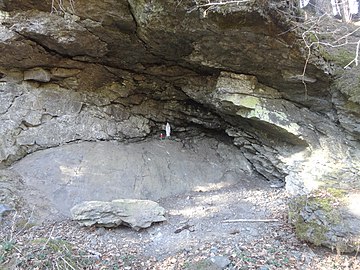
Burgstall Eulenburg
The Eulenburg castle stable is located on the Eulenburg mountain of the same name, 626 m above sea level. NN between the southern exit of Grafengehaig and the Hohenreuther settlement. According to oral tradition, it was a ruin around 1900, later it was removed and there are underground passages in the mountain.
Architectural monuments
Soil monuments
Nature and soil monuments
Steinachklamm
The Steinachklamm in the Steinach Valley marks the breakthrough of the Lower Steinach and is a natural monument . It is located southwest of Grafengehaig (about four kilometers), directly behind the municipal boundary below the village of Wildenstein, which already belongs to the municipality of Presseck . The rock walls of the Steinachklamm are made of quartz keratophyr , a very hard volcanic rock . Like a huge barrier wall, the rock bar lay against the watercourse of the Untere Steinach, until it had gnawed a breakthrough over thousands of years. The rocks stand on top of each other in mighty banks and in the past supported Wildenstein Castle on their summit .
The Steinachklamm has been designated by the Bavarian State Office for the Environment as Geotope 477R003 and has been awarded the official seal of approval for Bavaria's most beautiful geotopes .
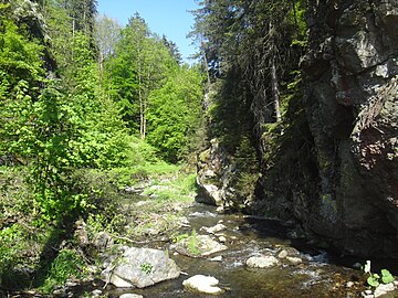
Steinachklamm
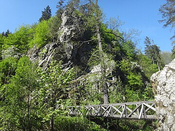
Steinachklamm


Eisenberg
The Eisenberg at 544 m above sea level. NN is about two kilometers southwest of Grafengehaig. The Seifersreuth district is located in a depression on its southern slope. The place name probably goes back to the mining of ore by soap .
The name of the mountain arose as a result of the local mining of iron ore , which was processed in the Guttenberg hammer and the gun hammer. The summit of the Eisenberg is a ground monument , on it was a prehistoric or prehistoric fortification, probably from the Celtic era . The Mühlenweg leads around the mountain.

Eisenberg from the west
Mariengrotte on Mühlenweg


Economy and Infrastructure
Industry, trade and commerce offer approx. 300 jobs (weaving mills, locksmiths, hammer mills, construction, food). There are also several farms with an agriculturally used area of 907 hectares, of which 613 hectares are arable land (as of 2012).
In Grafengehaig there is a general medical group practice as well as a practice for physiotherapy and an alternative practitioner in the community area. The Diakonieverein Grafengehaig / Presseck is responsible for nursing. There is a local helper (HvO) for the community area.
To supply the population there is a food market that also offers baked goods and meat products. In Grafengehaig there is the Frankenwaldhalle and an inn, in Seifersreuth, Schlockenau, Horbach and Weidmes there is a country inn and in Walberngrün there is a sports center.
Established businesses
The four largest companies in Grafengehaig are:
- Horn textiles - Horn KG
- J. Erhardt & Sohn GmbH & Co. KG
- Krumpholz tools
- Vießmann Bau GmbH
education
There are the following institutions (as of 2014):
- a kindergarten with 25 places
leisure
In the municipality there are 23 clubs . The landscape invites you to hiking , cycling , mountain biking and in winter for skiing , cross-country skiing and sledding one. In Grafengehaig there is a guesthouse and several holiday apartments .
- The Frankenwaldhalle offers a variety of options for sports and festive events . It is also used for concerts , theater performances and large events with a capacity of approx. 500–700 people.
- Walber green glacier

- Winter sports center in the Walberngrün district with floodlit trail (length approx. 2.5 kilometers, 80 meters in altitude). Around the winter sports center there are around 20 kilometers of groomed trails .
Sports
SV Grafengehaig
- Soccer
- Ladies gymnastics
SG Gösmes / Walberngrün
- Soccer
- Winter sports
- Gymnastics group
traffic
The community is connected to State Road 2158. The B 289 is six kilometers away and the A 9 is around 15 km away . There is a bus connection Kulmbach - Grafengehaig - Helmbrechts. The next train stations are in Untersteinach and Helmbrechts; these can also be reached by bus.
Personalities
- Herbert Hofmann (1936–2014), politician born in Grünlas, member of the Bavarian state parliament
literature
- Johann Kaspar Bundschuh : Grafengehaig . In: Geographical Statistical-Topographical Lexicon of Franconia . tape 2 : El-H . Verlag der Stettinische Buchhandlung, Ulm 1800, DNB 790364298 , OCLC 833753081 , Sp. 374 ( digitized version ).
- Pleikard Joseph Stumpf : Earl husband . In: Bavaria: a geographical-statistical-historical handbook of the kingdom; for the Bavarian people . Second part. Munich 1853, p. 641 ( digitized version ).
Web links
Individual evidence
- ↑ "Data 2" sheet, Statistical Report A1200C 202041 Population of the municipalities, districts and administrative districts 1st quarter 2020 (population based on the 2011 census) ( help ).
- ↑ http://www.bayerische-landesbibliothek-online.de/orte/ortssuche_action.html ? Anzeige=voll&modus=automat&tempus=+20111031/114311&attr=OBJ&val= 1265
- ^ Wilhelm Volkert (ed.): Handbook of Bavarian offices, communities and courts 1799–1980 . CH Beck, Munich 1983, ISBN 3-406-09669-7 , p. 574 .
- ↑ Statistics kopmmunal 2012: Grafenhaig (PDF; 1.7 MB)
- ↑ Municipal Council. Grafengehaig parish, accessed on August 2, 2020 .
- ^ Entry on Grafengehaig's coat of arms in the database of the House of Bavarian History
- ↑ Geotope: Steinachklamm near Wildenstein (accessed on October 21, 2013; PDF; 197 kB)
- ↑ Steinachklamm (accessed on October 21, 2013)

Earl wage | Guttenberg | Harsdorf | Sky crown | Kasendorf | Ködnitz | Kulmbach | Kupferberg | Ludwigschorgast | Mainleus | Marktleugast | Marktschorgast | Neudrossenfeld | Neuenmarkt | Presseck | Rugendorf | Stadtsteinach | Thurnau | Trebgast | Untereinach | Wirsberg | Wonsees