
Quarry mountain
| Quarry mountain
(Hohenreuth)
|
||
|---|---|---|
 Quarry mountain from the west with Grafengehaig |
||
| height | 681.3 m above sea level NHN | |
| location | Bavaria , Germany | |
| Mountains | Franconian Forest | |
| Notch height | 256.4 m | |
| Coordinates | 50 ° 12 '25 " N , 11 ° 36' 14" E | |
|
||
| rock | Diabase rock | |

The quarry mountain rises in the area of the Grafengehaig market in the Franconian Forest Nature Park . At 681.3 m above sea level NHN it is one of the highest mountains in the Kulmbach district . The village of Grafengehaig is located on the western slope.
Geography and geology
The quarry mountain is located in the southern part of the Franconian Forest and delimits the foothills of the Münchberg plateau towards Marktleugast-Münchberg to the south by the Rehbach valley . The height of the gap from the summit to the Rehbachtal is 184.6 m. In the west are the heights of the Franconian Forest with deep valleys as well as the Steinach Valley and the Steinach Gorge . The height of the gap from the summit to the Steinachtal is 256.4 m. In the north are the mountain ranges of the Franconian Forest with the Döbraberg , in the east the Fichtelgebirge . Geologically, the quarry mountain top consists of hard diabase rock. The south-west slope consists of rocks, the north-east slope consists mainly of fields and meadows.
history
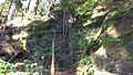
The name Steinbruchberg was often mentioned between the 15th and 19th centuries due to the quarries there. There are old quarries on the western slope above the village of Grafengehaig and on the eastern slope near Schindelwald. The west quarry with its high rock formations was mainly used to break hard diabase rock for regional construction projects. In the eastern quarry, however, iron and copper ore were brought to light from deep pits. The pits or mining shafts can still be clearly seen on almost the entire eastern slope. The name was last used in a topographical record from 1851. When the quarry stopped at the beginning of the 20th century, the name fell into oblivion. In the vernacular, the mountain is often referred to as "Hohenreuth", but this is the field name of the forest and meadow areas there.
tourism
On the southern slope of the quarry mountain above the Hohenreuther settlement of Grafengehaig is the lookout rock at an altitude of approx. 660 m above sea level. The Steinach Valley begins with the southwestern foothills with the Steinach Gorge. The Mühlenweg with the Rehbach Valley leads around the mountain.
Individual evidence
- ↑ a b Map services of the Federal Agency for Nature Conservation ( information )
- ↑ a b BayernAtlas of the Bavarian State Government ( notes )

Lookout rock looking south-west

Lookout rock facing southeast

Ascent through rocks

Rock formation
Old quarry mining area

Old quarry mining shaft


