
Limmersdorf
|
Limmersdorf
Thurnau market
Coordinates: 50 ° 0 ′ 32 ″ N , 11 ° 24 ′ 24 ″ E
|
|
|---|---|
| Height : | 400 m above sea level NHN |
| Residents : | 397 (May 25 1987) |
| Incorporation : | May 1, 1978 |
| Postal code : | 95349 |
| Area code : | 09228 |
 |
|
Limmersdorf is a district of the Thurnau market in the district of Kulmbach in Upper Franconia .
geography
The parish village lies in a flat hilly landscape, which mainly consists of arable land and grassland. The Breitenwieser Graben , a right tributary of the Aubach, flows through the village . In the east is the Limmersdorfer Forest . The district road KU 17 leads to Thurnau on state road 2189 (1.5 km north) or to Felkendorf (1.3 km south). The district road KU 19 leads to the district road KU 7 (0.6 km southwest). Municipal roads lead to Forstleithen (0.7 km east) and to KU 7 at junction 22 of the A 70 (1.1 km northwest).
An old sunken road from the Swabian Alb Kleetz over the desert Kröglitzen leads to Limmersdorf into Juratal.
history
The place was first mentioned in 1255 as "Lymarsdorf". In 1307 the place was called "Liemersdorf". The defining word is the personal name Limar. With the personal name the founder of the settlement was probably given.
In the 14th and 15th centuries, Limmersdorf was a branch of the Order of St. John . From 1510 to 1542 Eberhard I. Förtsch von Thurnau had today's late Gothic church built on the remains of the previous buildings. In the early 16th century the church became Evangelical Lutheran. The noble Giech family retained patronage for the church until 1848.
Towards the end of the 18th century, Limmersdorf consisted of 55 properties. The Giech'sche Amt Thurnau exercised the high court and the village and community rule . Were landlords
- the Thurnau office (39 properties: 6 courtyards, 3 half courtyards, 2 semi-estates, 2 quarter estates, 1 small estate, 5 Sölden , 3 half-sölden, 8 houses, 2 houses each with a courtyard, 5 small houses, 1 courtyard, 1 small courtyard),
- the hospital administration Thurnau (1 yard),
- the parish of Thurnau (1 undeveloped Sölde),
- the parish of Limmersdorf (11 properties: 1 blacksmith's house with Hofrait, 2 goods, 1 Söldengut, 4 Halbsölden, 1 third oil, 1 house, 1 drip house )
- the St. Katharinen-Spital Bamberg (3 estates, including 1 undeveloped).
The Thurnau office was responsible for the tax and bailiwick , with the exception of the Bamberg hospital's property: Here, the Bamberg office of Weismain was responsible for tax sovereignty . In addition to the property there was also 1 church, 1 rectory, 1 schoolhouse and 1 community blacksmith's shop.
From 1797 to 1808 the place was under the patrimonial court of Thurnau . With the municipal edict of 1811, the Limmersdorf tax district was formed, to which Berndorf , Felkendorf , Hohezorn , Kleetzhöfe , Leesau , Menchau , Poppenleithen , Quartier , Ruh and Wiesenmühle belonged. In 1812 Buchhaus , Forstleithen , Kröglitzen and Neuwirthshaus were added to the tax district . With the second community edict (1818) the rural community Limmersdorf was formed, to which Hörlinsreuth belonged. It was subject to the Hollfeld Regional Court in administration and jurisdiction and the Kulmbach Rent Office in the financial administration . In 1822 Limmersdorf was transferred to the Thurnau Regional Court (from 1852 Thurnau Regional Court ) and the Thurnau Rent Office ( renamed the Thurnau Tax Office in 1919 ). In 1856 the Buchhaus, Forstleithen and street inn were incorporated. From 1862 Limmersdorf was administered by the Kulmbach District Office (renamed the Kulmbach District in 1939 ). The jurisdiction remained with the district court of Thurnau until 1879, from 1879 district court of Thurnau . In 1929 jurisdiction was taken over by the Bayreuth District Court and in 1930 financial management by the Bayreuth Tax Office . In 1925, the municipality had an area of 5.688 km², which increased to 5.733 km² through the incorporation of Kröglitzen in 1930.
On April 14, 1945, a German military aircraft ( Messerschmitt Bf 109 ) crashed near the site. According to tradition, the pilot is said to have pulled the already burning aircraft up over the place to protect the residents. A monument with a part of the wreck bears witness to this event.
On April 1, 1971, the municipality of Felkendorf was incorporated into Limmersdorf as part of the regional reform . On May 1, 1978 Limmersdorf was incorporated into the Thurnau market.
Architectural monuments
- Evangelical Lutheran Parish Church of St. John
- Upper village 2: Evangelical Lutheran rectory
- Lower village 12: stable house
- Lower village 13: door frame
- Zum Forst 7: residential building
- War memorial
- two tortures
- several landmarks
- Tanzlinde
Population development
Limmersdorf community
| year | 1818 | 1840 | 1852 | 1855 | 1861 | 1867 | 1871 | 1875 | 1880 | 1885 | 1890 | 1895 | 1900 | 1905 | 1910 | 1919 | 1925 | 1933 | 1939 | 1946 | 1950 | 1952 | 1961 | 1970 |
|---|---|---|---|---|---|---|---|---|---|---|---|---|---|---|---|---|---|---|---|---|---|---|---|---|
| Residents | 332 | 410 | 495 | 465 | 518 | 499 | 491 | 468 | 519 | 532 | 463 | 415 | 409 | 414 | 444 | 427 | 413 | 421 | 425 | 593 | 609 | 546 | 460 | 427 |
| Houses | 66 | 76 | 76 | 82 | 85 | 88 | 97 | |||||||||||||||||
| source |
Place Limmersdorf
| year | 1809 | 1818 | 1861 | 1871 | 1885 | 1900 | 1925 | 1950 | 1961 | 1970 | 1987 |
|---|---|---|---|---|---|---|---|---|---|---|---|
| Residents | 330 | 292 | 418 | 396 | 421 | 329 | 351 | 500 | 373 | 358 | 397 |
| Houses | 61 | 61 | 65 | 70 | 71 | 80 | 117 | ||||
| source |
Lindenkirchweih
Limmersdorf is known for the 350 year old linden tree and the Lindenkirchweih, which has been documented since 1729. In fact, this festival is probably much older. This tradition - unique in Germany - is cultivated annually. Today's Tanzlinde may have been planted at the end of the Thirty Years War in 1648. There are legends that indicate that there was already a Lindenkirchweih at that time. The linden tree is around 16 meters high with a trunk circumference of five meters. The dance floor is about four meters high. As a special feature, there is also a sand bowling alley operated by Kerwa .
In the spring of 2014, the Bavarian Council of Ministers decided to propose the Lindenkirchweih for entry in the nationwide register of intangible cultural heritage . In December 2014, the application was accepted and confirmed by the Conference of Ministers of Education . The Lindenkirchweih is one of 27 cultural forms in the German directory of intangible cultural heritage .
photos
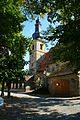
Church in Limmersdorf with Tanzlinde on the left
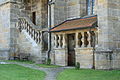
Limmersdorf Church side entrance

Limmersdorf aviator memorial
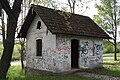
Former train station


literature
- Rüdiger Barth: Kulmbach: City and Altlandkreis (= Historical Atlas of Bavaria, part of Franconia . I, 38). Commission for Bavarian State History, Munich 2012, ISBN 978-3-7696-6554-3 .
- Johann Kaspar Bundschuh : Limmersdorf . In: Geographical Statistical-Topographical Lexicon of Franconia . tape 3 : I-Ne . Verlag der Stettinische Buchhandlung, Ulm 1801, DNB 790364301 , OCLC 833753092 , Sp. 565 ( digitized version ).
- August Gebeßler : City and district of Kulmbach (= Bavarian art monuments . Volume 3 ). Deutscher Kunstverlag, Munich 1958, DNB 451450973 , p. 68-70 .
- Erich Freiherr von Guttenberg : Land and city district of Kulmbach (= historical book of place names of Bavaria, Upper Franconia . Volume 1 ). Commission for Bavarian State History, Munich 1952, DNB 451738918 , p. 97-98 .
- Thomas Münch: The Thurnau market with its districts . Geiger, Horb am Neckar 1993, ISBN 3-89264-785-2
Web links
- Limmersdorf on the website www.thurnau.de
- Limmersdorf in the location database of the Bavarian State Library Online . Bavarian State Library, accessed on August 11, 2020.
- Limmersdorf in the Topographia Franconiae of the University of Würzburg , accessed on August 11, 2020.
- Limmersdorf in the historical directory of the Association for Computer Genealogy , accessed on August 11, 2020
- Lindenkerwa website
- Site of the church of Limmersdorf
Individual evidence
- ↑ a b Bavarian State Office for Statistics and Data Processing (Ed.): Official local directory for Bavaria, territorial status: May 25, 1987 . Issue 450 of the articles on Bavaria's statistics. Munich November 1991, DNB 94240937X , p. 316 ( digitized ).
- ↑ Limmersdorf in the Bavaria Atlas
- ^ EF v. Guttenberg, pp. 97f.
- ↑ R. Barth, p. 615f. 51 properties are incorrectly listed there.
- ↑ a b c R. Barth, p. 762.
- ↑ a b c Bavarian State Statistical Office (ed.): Localities directory for the Free State of Bavaria according to the census of June 16, 1925 and the territorial status of January 1, 1928 . Issue 109 of the articles on Bavaria's statistics. Munich 1928, Section II, Sp. 1105 ( digitized version ).
- ↑ a b c Bavarian State Statistical Office (Hrsg.): Official local directory for Bavaria - edited on the basis of the census of September 13, 1950 . Issue 169 of the articles on Bavaria's statistics. Munich 1952, DNB 453660975 , Section II, Sp. 951 ( digitized version ).
- ^ Wilhelm Volkert (ed.): Handbook of Bavarian offices, communities and courts 1799–1980 . CH Beck, Munich 1983, ISBN 3-406-09669-7 , p. 503 .
- ^ Federal Statistical Office (ed.): Historical municipality directory for the Federal Republic of Germany. Name, border and key number changes in municipalities, counties and administrative districts from May 27, 1970 to December 31, 1982 . W. Kohlhammer, Stuttgart / Mainz 1983, ISBN 3-17-003263-1 , p. 693 .
- ↑ a b Only inhabited houses are given. From 1871 to 1987 these are called residential buildings .
- ↑ a b c d e f g h i j k l m n o Bavarian State Statistical Office (Hrsg.): Historical municipality register: The population of the municipalities of Bavaria from 1840 to 1952 (= contributions to Statistics Bavaria . Issue 192). Munich 1954, DNB 451478568 , p. 150 , urn : nbn: de: bvb: 12-bsb00066439-3 ( digitized version ).
- ↑ a b Joseph Heyberger, Chr. Schmitt, v. Wachter: Topographical-statistical manual of the Kingdom of Bavaria with an alphabetical local dictionary . In: K. Bayer. Statistical Bureau (Ed.): Bavaria. Regional and folklore of the Kingdom of Bavaria . tape 5 . Literary and artistic establishment of the JG Cotta'schen Buchhandlung, Munich 1867, Sp. 900 , urn : nbn: de: bvb: 12-bsb10374496-4 ( digitized version ).
- ↑ a b Kgl. Statistical Bureau (ed.): Complete list of localities of the Kingdom of Bavaria. According to districts, administrative districts, court districts and municipalities, including parish, school and post office affiliation ... with an alphabetical general register containing the population according to the results of the census of December 1, 1875 . Adolf Ackermann, Munich 1877, 2nd section (population figures from 1871, cattle figures from 1873), Sp. 1074 , urn : nbn: de: bvb: 12-bsb00052489-4 ( digitized ).
- ↑ a b K. Bayer. Statistical Bureau (Ed.): Localities directory of the Kingdom of Bavaria. According to government districts, administrative districts, ... then with an alphabetical register of locations, including the property and the responsible administrative district for each location. LIV. Issue of the contributions to the statistics of the Kingdom of Bavaria. Munich 1888, Section III, Sp. 1022 ( digitized version ).
- ↑ a b K. Bayer. Statistical Bureau (Ed.): Directory of localities of the Kingdom of Bavaria, with alphabetical register of places . LXV. Issue of the contributions to the statistics of the Kingdom of Bavaria. Munich 1904, Section II, Sp. 1070 ( digitized version ).
- ↑ a b Bavarian State Statistical Office (ed.): Official city directory for Bavaria, territorial status on October 1, 1964 with statistical information from the 1961 census . Issue 260 of the articles on Bavaria's statistics. Munich 1964, DNB 453660959 , Section II, Sp. 699 ( digitized version ).
- ↑ a b Bavarian State Statistical Office (Hrsg.): Official local directory for Bavaria . Issue 335 of the articles on Bavaria's statistics. Munich 1973, DNB 740801384 , p. 161 ( digitized version ).
- ↑ R. Barth, p. 728.
- ↑ Rainer Graefe: Buildings from living trees: guided dance and court linden trees . Geymüller, Publishing House for Architecture, Aachen [u. a.] 2014, ISBN 978-3-943164-08-4 , pp. 88 f .
- ↑ Lindenkirchweih: Tanzlinde is to become a world cultural heritage ( memento of April 7, 2014 in the Internet Archive ). BR.de, April 1, 2014.
- ↑ unesco.de

Alladorf | Construction hole | Berndorf | Book hole | Eckersdorf | Fahrbühl | Fall Mastery | Felkendorf | Forstleithen | Friezes | Hammerhaus (near Hutschdorf) | Hammerhaus (near Lanzenreuth) | High anger | Hörlinreuth | Hutschdorf | Hutweide | Katzenlohe | Kemeritz | Kleetzhöfe | Kröglitzen | Lanzenreuth | Leesau | Limmersdorf | Lochau | Meißnersleithen | Menchau | Neidsmühle | Neuwirthshaus | Oberschorrmühle | Oberwolfsknock | Partenfeld | Poppenleithen | Cleaning stone | Quarter | Reuthof | Rottlersreuth | Rest | Schlottermühle | Tannfeld | Thurnau | Todtenhaus | Trumsdorf | Unterschorrmühle | Meadow mill
Desolations: book house | Mühlberg | Underwolf Knock | Weiherhaus