
Parish church
|
Parish church
Large district town of Kulmbach
Coordinates: 50 ° 10 ′ 15 ″ N , 11 ° 23 ′ 2 ″ E
|
|
|---|---|
| Height : | 417 (415–456) m above sea level NHN |
| Residents : | 288 (Dec. 31, 2007) |
| Incorporation : | January 1, 1976 |
| Postal code : | 95326 |
| Area code : | 09221 |
Kirchleus (colloquially: Käʳleus ) is a district of the large district town of Kulmbach in Upper Franconia .
geography
The parish village is located in the deeply cut valley of the Geretsbach, which flows into the Leßbach, a left tributary of the Rodach . 1 km to the west is the Knock ( 513 m above sea level ), 0.8 km north-east of the Stennesberg ( 512 m above sea level ), both hills of the Kirchleuser Platte, which are part of the Upper Main hill country . At the Stennesberg there is a tree that has been designated a natural monument . The place is essentially surrounded by arable land and grassland.
The B 85 leads to Weißenbrunn (4.2 km northwest) or to Kulmbach to the B 289 (7.5 km southeast). The district road KU 33 leads to Schimmendorf (2.6 km southwest). Municipal roads lead to Unterdornlach (2.4 km southeast), to Gössersdorf to the district road KC 6 (2.4 km northeast) and to a municipal road near Esbach (1.6 km northeast).
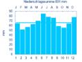
Diagram of precipitation mean values in Kirchleus for the period from 1961 to 1990


In Kirchleus the average amount of precipitation a year is 801 millimeters.
history
The place was first mentioned by name in 1148 as "Liubisse". The place name is derived from the Slavic personal name Ljuboslav. From this it can be concluded that the first settlers were Slavs . This is also indicated by the names of the adjacent parcels, which also have Slavic names (Diebitzen, Geritzen). In a document from 1249 the place was called "Kerleuss", which makes it clear that the place already had a church at that time. From the original church dedicated to Saint Mary Magdalene . The Slav settlement was soon followed by the settlement of Franconian farmers. It became common practice to call the older settlement “Oberleus” (popularly also called “Kalfeggn”) and the younger “Unterleus”. The village was originally subordinate to the Lords of Plassenberg and from 1248 to the Bamberg office of Stadtsteinach . In 1524 it fell to the Principality of Kulmbach and in 1528, like the entire Principality, became Protestant. From 1575 the place had a village school. It was dissolved in 1969 after almost 400 years.
Kirchleus was looted and destroyed in the Thirty Years War .
Towards the end of the 18th century there were 46 properties in Kirchleus. The high court was exercised by the Bavarian Bailiwick of Kulmbach . The village and township government had the box office Kulmbach held. Were landlords
- the Principality of Bayreuth (9 properties; box office Kulmbach: 1 farrier's shop, 1 drip house , 5 drip house; margravial fiefdom Bayreuth : 1 half courtyard ; Kulmbach community hospital : 2 small farms)
- the Bamberg bishopric (14 properties; Langheimer Amtshof : 6 courtyards, 2 half courtyards, 1 estate, 1 estate, 3 Sölden , 1 forester's apartment)
- the manor Kirchleus (21 properties; Amt I: 1 inn with brewery and court yard, 4 estates, 1 Gütlein, 1 Söldengut, 1 drip house, 4 houses, 1 dwelling house; Amt II: 1 courtyard, 1 tavern, 6 Sölden)
- the manor Steinenhausen (1 inn, 1 Sölde).
There was also 1 castle with farm buildings, 1 church, 1 parsonage with courtyard, 1 schoolhouse with courtyard and 1 shepherd's house.
From 1797 to 1808 the place was subordinate to the justice and chamber office Kulmbach . With the municipal edict, the Kirchleus tax district was formed in 1811 , to which the towns of Einsiedel , Esbach , Holzmühle , Lösau , Mühlberg , Schimmendorf , Straß , Wehrhaus and Welzmühle belonged. In 1812 the rural community of Kirchleus was formed, which was congruent with the tax district. With the second community edict of 1818 , three rural communities were formed:
- Church with Welzmühle
- Losau with Einsiedel, Esbach, Holzmühle and Whermühle
- Schimmendorf with Mühlberg and Straß.
The administration and jurisdiction of the rural community of Kirchleus was subordinate to the Kulmbach Regional Court and the Kulmbach Rent Office ( renamed the Kulmbach Tax Office in 1919 ). Until 1848, 23 properties were subject to voluntary jurisdiction by the Patrimonial Court of Kirchleus, 2 properties were also subject to the PG Steinenhausen until 1848 . From 1862 Kirchleus was administered by the Kulmbach District Office (renamed the Kulmbach District in 1939 ). Jurisdiction remained with the Kulmbach Regional Court until 1879, and from 1879 the Kulmbach Local Court . The municipality had an area of 6.824 km².
On November 1, 1919, a police station was set up in Niklashof, the district of which was almost congruent with the parish of Kirchleus. On July 1, 1928, the post was revoked; the locations were looked after from Weißenbrunn.
The regional reform in Bavaria envisaged the formation of larger communities. For Kirchleus this meant the loss of political independence on January 1, 1976. The majority of the population decided to move to Kulmbach. The formation of a new community with other villages north of Kulmbach or incorporation into Weißenbrunn was also discussed. Since then the village has been represented by a local spokesman.
Architectural monuments
- House No. 34: Former castle of the Barons von Guttenberg, two-storey mansard hipped roof with sandstone structure, 1740; Outbuilding, probably 18./19. century
- House No. 41: Former brewery, two-story two-wing building with a round arched gate entrance, hipped roof, marked 1770 and 1865.
- House No. 53: Former manor house, two-story hipped roof building, 17th / 18th centuries century
- House No. 59: Two-story house, on the upper floor with four to six windows; probably 17./18. Century. First floor window with bevelled walls; Hipped roof.
- House No. 63: Evangelical Lutheran parish church of St. Maria Magdalena , the core of the late Gothic choir tower church, redesigned in Baroque style from 1774–76; with equipment; Churchyard with tombs and walling
Population development
Kirchleus parish
| year | 1818 | 1840 | 1852 | 1855 | 1861 | 1867 | 1871 | 1875 | 1880 | 1885 | 1890 | 1895 | 1900 | 1905 | 1910 | 1919 | 1925 | 1933 | 1939 | 1946 | 1950 | 1952 | 1961 | 1970 |
|---|---|---|---|---|---|---|---|---|---|---|---|---|---|---|---|---|---|---|---|---|---|---|---|---|
| Residents | 320 | 414 | 439 | 429 | 433 | 456 | 435 | 418 | 412 | 405 | 364 | 354 | 338 | 336 | 371 | 367 | 336 | 302 | 282 | 377 | 390 | 380 | 315 | 270 |
| Houses | 58 | 64 | 66 | 66 | 68 | 64 | 66 | |||||||||||||||||
| source |
Place Kirchleus
| year | 1809 | 1818 | 1861 | 1871 | 1885 | 1900 | 1925 | 1950 | 1961 | 1970 | 1987 | 2007 |
|---|---|---|---|---|---|---|---|---|---|---|---|---|
| Residents | 316 * | 320 * | 430 | 430 | 395 | 332 | 327 | 386 | 308 | 265 | 249 | 288 |
| Houses | 58 * | 65 | 64 | 67 | 63 | 54 | 74 | |||||
| source |
mayor
- Johann Wagner (???? - 1842)
- Johann Adam Stumpf (1842-1854)
- Andreas Limmer (1854–1866)
- Johann Bauer (1866–1882)
- Johann Häublein (1882-1894)
- Ernst Grethlein (1894–1906)
- Johann Wilhelm Beck (1906–1933)
- Ferdinand Kern (1933 - ????)
- Ernst Ruppert (???? - 1945)
- Hans Häublein (1945–1948)
- Ernst Ruppert (1948–1965)
- Hans Lerner (1966–1975)
- Gerhard Limmer
- Richard Stroebel
literature
- Rüdiger Barth: Kulmbach: City and Altlandkreis (= Historical Atlas of Bavaria, part of Franconia . I, 38). Commission for Bavarian State History, Munich 2012, ISBN 978-3-7696-6554-3 .
- Johann Kaspar Bundschuh : Kerleuss . In: Geographical Statistical-Topographical Lexicon of Franconia . tape 3 : I-Ne . Verlag der Stettinische Buchhandlung, Ulm 1801, DNB 790364301 , OCLC 833753092 , Sp. 79 ( digitized version ).
- Johann Kaspar Bundschuh : Kirchleiß . In: Geographical Statistical-Topographical Lexicon of Franconia . tape 3 : I-Ne . Verlag der Stettinische Buchhandlung, Ulm 1801, DNB 790364301 , OCLC 833753092 , Sp. 110 ( digitized version ).
- August Gebeßler : City and district of Kulmbach (= Bavarian art monuments . Volume 3 ). Deutscher Kunstverlag, Munich 1958, DNB 451450973 , p. 64-65 .
- Erich Freiherr von Guttenberg : Land and city district of Kulmbach (= historical book of place names of Bavaria, Upper Franconia . Volume 1 ). Commission for Bavarian State History, Munich 1952, DNB 451738918 , p. 78-80 .
- Georg Paul Hönn : Kerleuss . In: Lexicon Topographicum of the Franconian Craises . Johann Georg Lochner, Frankfurt and Leipzig 1747, p. 265 ( digitized version ).
- Georg Paul Hönn : Kirchleiß . In: Lexicon Topographicum of the Franconian Craises . Johann Georg Lochner, Frankfurt and Leipzig 1747, p. 265 ( digitized version ).
- Hans Jakob: The Schamelstein near Kirchleus . In: Archive for the history of Upper Franconia . tape 59 , 1979, pp. 15-24 .
- Manfred Voigt: Church. The story of a small village . Kulmbach 1998.
Web links
- Kirchleus in the location database of the Bavarian State Library Online . Bavarian State Library
- Church in the Topographia Franconiae of the University of Würzburg , accessed on September 14, 2019.
- Kirchleus in the historical directory of the association for computer genealogy
Individual evidence
- ^ EF v. Guttenberg, p. 200.
- ^ Church in the Bavaria Atlas
- ↑ E. v. Guttenberg, p. 78ff.
- ↑ M. Voigt, pp. 1-3.
- ↑ M. Voigt, pp. 7-12.
- ↑ M. Voigt, pp. 15-22.
- ↑ M. Voigt, p. 157f.
- ↑ M. Voigt, pp. 23–31.
- ↑ R. Barth, pp. 608f.
- ↑ R. Barth, p. 759.
- ↑ R. Barth, p. 794.
- ↑ R. Barth, pp. 758f.
- ↑ a b c Bavarian State Statistical Office (ed.): Official city directory for Bavaria, territorial status on October 1, 1964 with statistical information from the 1961 census . Issue 260 of the articles on Bavaria's statistics. Munich 1964, DNB 453660959 , Section II, Sp. 698 ( digitized version ).
- ↑ M. Voigt, p. 99.
- ^ Federal Statistical Office (ed.): Historical municipality directory for the Federal Republic of Germany. Name, border and key number changes in municipalities, counties and administrative districts from May 27, 1970 to December 31, 1982 . W. Kohlhammer, Stuttgart / Mainz 1983, ISBN 3-17-003263-1 , p. 692 .
- ↑ M. Voigt, p. 159f.
- ↑ A. Gebeßler, p. 65. Monument protection canceled, object possibly demolished.
- ↑ a b Only inhabited houses are given. From 1871 to 1987 these are called residential buildings .
- ↑ a b R. Barth, p. 758.
- ↑ a b c d e f g h i j k l m n o Bavarian State Statistical Office (Hrsg.): Historical municipality register: The population of the municipalities of Bavaria from 1840 to 1952 (= contributions to Statistics Bavaria . Issue 192). Munich 1954, DNB 451478568 , p. 150 , urn : nbn: de: bvb: 12-bsb00066439-3 ( digitized version ).
- ↑ a b Joseph Heyberger, Chr. Schmitt, v. Wachter: Topographical-statistical manual of the Kingdom of Bavaria with an alphabetical local dictionary . In: K. Bayer. Statistical Bureau (Ed.): Bavaria. Regional and folklore of the Kingdom of Bavaria . tape 5 . Literary and artistic establishment of the JG Cotta'schen Buchhandlung, Munich 1867, Sp. 896 , urn : nbn: de: bvb: 12-bsb10374496-4 ( digitized version ).
- ↑ a b Kgl. Statistical Bureau (ed.): Complete list of localities of the Kingdom of Bavaria. According to districts, administrative districts, court districts and municipalities, including parish, school and post office affiliation ... with an alphabetical general register containing the population according to the results of the census of December 1, 1875 . Adolf Ackermann, Munich 1877, 2nd section (population figures from 1871, cattle figures from 1873), Sp. 1067-1068 , urn : nbn: de: bvb: 12-bsb00052489-4 ( digital copy ).
- ↑ a b K. Bayer. Statistical Bureau (Ed.): Localities directory of the Kingdom of Bavaria. According to government districts, administrative districts, ... then with an alphabetical register of locations, including the property and the responsible administrative district for each location. LIV. Issue of the contributions to the statistics of the Kingdom of Bavaria. Munich 1888, Section III, Sp. 1016 ( digitized version ).
- ↑ a b K. Bayer. Statistical Bureau (Ed.): Directory of localities of the Kingdom of Bavaria, with alphabetical register of places . LXV. Issue of the contributions to the statistics of the Kingdom of Bavaria. Munich 1904, Section II, Sp. 1063 ( digitized version ).
- ↑ a b Bavarian State Statistical Office (ed.): Localities directory for the Free State of Bavaria according to the census of June 16, 1925 and the territorial status of January 1, 1928 . Issue 109 of the articles on Bavaria's statistics. Munich 1928, Section II, Sp. 1098 ( digitized version ).
- ↑ a b Bavarian State Statistical Office (ed.): Official place directory for Bavaria - edited on the basis of the census of September 13, 1950 . Issue 169 of the articles on Bavaria's statistics. Munich 1952, DNB 453660975 , Section II, Sp. 949 ( digitized version ).
- ↑ a b Bavarian State Statistical Office (Hrsg.): Official local directory for Bavaria . Issue 335 of the articles on Bavaria's statistics. Munich 1973, DNB 740801384 , p. 161 ( digitized version ).
- ↑ R. Barth, p. 725.
- ↑ Bavarian State Office for Statistics and Data Processing (Ed.): Official local directory for Bavaria, territorial status: May 25, 1987 . Issue 450 of the articles on Bavaria's statistics. Munich November 1991, DNB 94240937X , p. 314 ( digitized version ).

Affalterhof | Aichig | Altenreuth | Ant hole | Bärnhof | Baumgarten | Flexible material | Blaich | Burghaig | Donnersreuth | Dörnhof | Eggenreuth | Einsiedel | Esbach | Forest lame | Frankenberg | Freshness mill | Yellow Willows | Gemlenz | Gößmannsreuth | Grafendobrach | Green tree | Basic house | Herlas | Hitzmain | Courtier | Höfstätten | Wooden mill | Katschenreuth | Kauernburg | Boiler | Church | Kulmbach | Lehenthal | Leuchau | Lindig | Losau | Mangersreuth | Melkendorf | Metzdorf | Neufang | Niederndobrach | Oberauhof | Oberdornlach | Oberkodach | Oberndorf | Oberpurbach | Oberzettlitz | Petzmannsberg | Plassenburg | Plosenberg | Pörbitsch | Priemershof | Ramscheid | Rosengrund | Rothenhügl | Rother Hill | Sackenreuth | Blackwood | Seidenhof | Steinenhausen | Stone house | Tiefenbach | Unterdornlach | Lower compartment | Unterpurbach | Unterzettlitz | Venetian barn | Calf | Fortified house | Pond | Vine bridge | Welzmühle | Wickenreuth | Windischenhaig | Brick huts