
Steinenhausen
|
Steinenhausen
Large district town of Kulmbach
Coordinates: 50 ° 5 ′ 13 ″ N , 11 ° 24 ′ 4 ″ E
|
|
|---|---|
| Height : | 305 m above sea level NHN |
| Postal code : | 95326 |
| Area code : | 09221 |
Steinenhausen is a district of the large district town of Kulmbach in the district of the same name in Bavaria .
geography
Steinenhausen lies at the confluence of the Red and White Mains . The closest places are Frankenberg , Melkendorf and Katschenreuth .
history
In 1316 a mill "ze dem Steinhaus" was mentioned. This is also the first written mention of the place.
Towards the end of the 18th century there was 1 castle with an economic building and 3 properties (2 courtyards, 1 residential building) in Steinenhausen. The high court was exercised by the Bavarian Bailiwick of Kulmbach . The manor Steinenhausen held the village and community rulership as well as the manor.
From 1797 to 1808 the place was subordinate to the justice and chamber office Kulmbach . With the community edict, Steinenhausen was assigned to the Schwarzach tax district formed in 1811 and the Melkendorf rural community formed in 1812 .
The Steinenhausen palace was owned by the Guttenberg family until 1935 . After the Second World War , refugees were housed. A little later it was used as a retirement home. Today there is a branch of the Bavarian State Office for the Environment .
On July 1, 1976, Steinenhausen was incorporated into Kulmbach as part of the regional reform in Bavaria .
monument
- House No. 1: Steinenhausen Castle
Population development
| year | 1809 | 1818 | 1861 | 1871 | 1885 | 1900 | 1925 | 1950 | 1961 | 1970 | 1987 |
|---|---|---|---|---|---|---|---|---|---|---|---|
| Residents | 22nd | 41 | 14th | 11 | 18th | 15th | 22nd | 156 | 122 | 107 | 66 |
| Houses | 5 | 3 | 1 | 2 | 3 | 2 | 1 | ||||
| source |
religion
Steinenhausen belongs to the parish of St. Aegidius Melkendorf and is therefore Evangelical-Lutheran .
photos
- photos
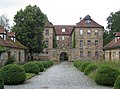
Steinenhausen Castle

The Mainz confluence

The Main near Steinenhausen

The Main Bridge over the confluence

Mill in Steinenhausen


literature
- Rüdiger Barth: Kulmbach: City and Altlandkreis (= Historical Atlas of Bavaria, part of Franconia . I, 38). Commission for Bavarian State History, Munich 2012, ISBN 978-3-7696-6554-3 .
- Johann Kaspar Bundschuh : Steinhausen . In: Geographical Statistical-Topographical Lexicon of Franconia . tape 5 : S-U . Verlag der Stettinische Buchhandlung, Ulm 1802, DNB 790364328 , OCLC 833753112 , Sp. 431-432 ( digitized version ).
- August Gebeßler : City and district of Kulmbach (= Bavarian art monuments . Volume 3 ). Deutscher Kunstverlag, Munich 1958, DNB 451450973 , p. 86-87 .
- Erich Freiherr von Guttenberg : Land and city district of Kulmbach (= historical book of place names of Bavaria, Upper Franconia . Volume 1 ). Commission for Bavarian State History, Munich 1952, DNB 451738918 , p. 157-158 .
Web links
- Steinenhausen in the location database of the Bavarian State Library Online . Bavarian State Library, accessed on August 5, 2020.
- Steinenhausen in the Topographia Franconiae of the University of Würzburg , accessed on August 5, 2020.
- Steinenhausen in the historical directory of the Verein für Computergenealogie , accessed on August 5, 2020
Individual evidence
- ↑ Steinenhausen in the Bavaria Atlas
- ^ EF v. Guttenberg, p. 158.
- ↑ R. Barth, p. 641.
- ↑ R. Barth, p. 766.
- ↑ R. Barth, p. 788.
- ↑ R. Barth, p. 786.
- ↑ a b Bavarian State Statistical Office (ed.): Official city directory for Bavaria, territorial status on October 1, 1964 with statistical information from the 1961 census . Issue 260 of the articles on Bavaria's statistics. Munich 1964, DNB 453660959 , Section II, Sp. 700 ( digitized version ).
- ↑ Location Kulmbach on the website lfu.bayern.de
- ↑ Only inhabited houses are given. From 1871 to 1987 these are called residential buildings .
- ↑ R. Barth, p. 726.
- ↑ R. Barth, p. 765.
- ^ Joseph Heyberger, Chr. Schmitt, v. Wachter: Topographical-statistical manual of the Kingdom of Bavaria with an alphabetical local dictionary . In: K. Bayer. Statistical Bureau (Ed.): Bavaria. Regional and folklore of the Kingdom of Bavaria . tape 5 . Literary and artistic establishment of the JG Cotta'schen Buchhandlung, Munich 1867, Sp. 897 , urn : nbn: de: bvb: 12-bsb10374496-4 ( digital copy ).
- ↑ Kgl. Statistical Bureau (ed.): Complete list of localities of the Kingdom of Bavaria. According to districts, administrative districts, court districts and municipalities, including parish, school and post office affiliation ... with an alphabetical general register containing the population according to the results of the census of December 1, 1875 . Adolf Ackermann, Munich 1877, 2nd section (population figures from 1871, cattle figures from 1873), Sp. 1070 , urn : nbn: de: bvb: 12-bsb00052489-4 ( digital copy ).
- ↑ K. Bayer. Statistical Bureau (Ed.): Localities directory of the Kingdom of Bavaria. According to government districts, administrative districts, ... then with an alphabetical register of locations, including the property and the responsible administrative district for each location. LIV. Issue of the contributions to the statistics of the Kingdom of Bavaria. Munich 1888, Section III, Sp. 1018 ( digitized version ).
- ↑ K. Bayer. Statistical Bureau (Ed.): Directory of localities of the Kingdom of Bavaria, with alphabetical register of places . LXV. Issue of the contributions to the statistics of the Kingdom of Bavaria. Munich 1904, Section II, Sp. 1065 ( digitized version ).
- ↑ Bavarian State Statistical Office (ed.): Localities directory for the Free State of Bavaria according to the census of June 16, 1925 and the territorial status of January 1, 1928 . Issue 109 of the articles on Bavaria's statistics. Munich 1928, Section II, Sp. 1100 ( digitized version ).
- ↑ Bavarian State Statistical Office (ed.): Official place directory for Bavaria - edited on the basis of the census of September 13, 1950 . Issue 169 of the articles on Bavaria's statistics. Munich 1952, DNB 453660975 , Section II, Sp. 952 ( digitized version ).
- ^ Bavarian State Statistical Office (ed.): Official place directory for Bavaria . Issue 335 of the articles on Bavaria's statistics. Munich 1973, DNB 740801384 , p. 162 ( digitized version ).
- ↑ Bavarian State Office for Statistics and Data Processing (Ed.): Official local directory for Bavaria, territorial status: May 25, 1987 . Issue 450 of the articles on Bavaria's statistics. Munich November 1991, DNB 94240937X , p. 314 ( digitized version ).

Affalterhof | Aichig | Altenreuth | Ant hole | Bärnhof | Baumgarten | Flexible material | Blaich | Burghaig | Donnersreuth | Dörnhof | Eggenreuth | Einsiedel | Esbach | Forest lame | Frankenberg | Freshness mill | Yellow Willows | Gemlenz | Gößmannsreuth | Grafendobrach | Green tree | Basic house | Herlas | Hitzmain | Courtier | Höfstätten | Wooden mill | Katschenreuth | Kauernburg | Boiler | Church | Kulmbach | Lehenthal | Leuchau | Lindig | Losau | Mangersreuth | Melkendorf | Metzdorf | Neufang | Niederndobrach | Oberauhof | Oberdornlach | Oberkodach | Oberndorf | Oberpurbach | Oberzettlitz | Petzmannsberg | Plassenburg | Plosenberg | Pörbitsch | Priemershof | Ramscheid | Rosengrund | Rothenhügl | Rother Hill | Sackenreuth | Blackwood | Seidenhof | Steinenhausen | Stone house | Tiefenbach | Unterdornlach | Lower compartment | Unterpurbach | Unterzettlitz | Venetian barn | Calf | Fortified house | Pond | Vine bridge | Welzmühle | Wickenreuth | Windischenhaig | Brick huts