Kammerberg (Fahrenzhausen)
|
Kammerberg
municipality Fahrenzhausen
Coordinates: 48 ° 22 ′ 19 ″ N , 11 ° 31 ′ 1 ″ E
|
|
|---|---|
| Height : | 480 m above sea level NN |
| Residents : | 557 (Aug 8, 2002) |
| Incorporation : | May 1, 1978 |
| Postal code : | 85777 |
| Area code : | 08137 |
Kammerberg is the westernmost part of the municipality of Fahrenzhausen in the district of Freising ( Upper Bavaria ). Before the regional reform , Kammerberg was an independent municipality.
geography
Kammerberg is rural, about 3.8 kilometers northwest of Fahrenzhausen, surrounded by the neighboring villages of Gramling, Giebing, Piflitz, Kollbach, Weißling, Lauterbach, Bachenhausen and Viehbach. The B13 runs about one kilometer east of Kammerberg . The Kammerberg Forest, called Hiakl , connects to the south . The Rettenbach flows west of Kammerberg.
history
Kammerberg is first documented as "Perga" between 1006 and 1029. In 1315 this place was called "Chamerberch". He had a close family relationship with Hohenkammer . The family members of the “Chammerberger” served the Bavarian dukes as ministerials from the 13th to the 15th century and were primarily active as judges and carers. Kammerberg was a Bavarian Hofmark that belonged to the district court of Kranzberg .
In the course of the formation of the community after the second community edict of 1818, the community of Kammerberg was also established. On May 1, 1978, the previously independent community was incorporated into Fahrenzhausen.
Castle and noble family
The Kammerberg Castle (built in the 17th / 18th centuries) was originally a four-wing complex and was redesigned several times (south wing was redesigned in a classicist style after 1828, west wing rebuilt in 1790). Today it is surrounded by a moat. In 1814 it was bought by the Unterbruck postman Karl Friedrich von Paur (1780–1854). The barons of Vequel-Westernach have lived in the castle since 1826 .
education
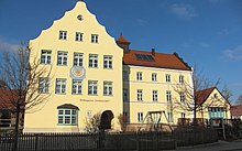
The former Kammerberg elementary school was renovated in 1998 and has been open to 79 children a year as a community kindergarten Sonnenschein .
church
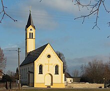
Kammerberg has been part of the Giebing parish since 1804 , which in turn forms a parish association with Jarzt and Weng . It is known that the first church in Kammerberg was built in 1315 . At the place where today's St.Johannes d.Täufer Church is built, there was previously a house of God built around 1610, which was rebuilt in 1890 in the style of historicism . Among other things, there is a family grave (family vault) of the noble family of Kammerberg in the church. The bells drawn in during World War II were replaced in 1949.
Culture
Architectural monuments
Kammerberg has a number of protected architectural monuments, which are recorded in the list of architectural monuments in Fahrenzhausen # Kammerberg .
societies
The following associations are based in Kammerberg:
- SpVgg Kammerberg eV
- Departments: football, women's gymnastics, theater, skiing
- Founded: 1947
- Faschingsverein Kammerberg-Fahrenzhausen eV
- Carnival Guard, Children's Guard
- Founded: 1979 (first as a subdivision of the SpVgg, later as an independently registered association)
- Shooting Society Cimbria Kammerberg eV
- Founded: 1877
-
Voluntary fire brigade Kammerberg eV
- Founded: March 15, 1875
- Warrior and Soldier Association Kammerberg eV
- Founded: January 26, 1919
The different clubs maintain a regular and committed club life with various events:
- SpVgg Kammerberg: including summer football tournament, ski course trips, theater events, Fun 4 Kids Day.
- Faschingsverein: Ua Gehts Ball , enthronement ball , strong beer festival, carnival parade (Bachenhausen - Kammerberg - Fahrenzhausen), "Fun 4 Kids" day.
- Cimbria Kammerberg: including a rifle grill festival, summer archery, bike rally.
- Voluntary fire brigade Kammerberg: including fire brigade barbecue and regular training exercises in the local area on the first Monday of the month.
- Warriors & Soldiers Association: including a barbecue.
energy
Bürger Wind Turbine Kammerberg, Enercon E-115 wind turbine with a hub height of 149 meters (total height: 207 meters).
Web links
Individual evidence
- ↑ http://www.kirchenundkapellen.de/kirchenko/kammerberg.php
- ↑ http://www.fahrenzhausen.org/orte/kamberg.htm
- ^ Federal Statistical Office (ed.): Historical municipality directory for the Federal Republic of Germany. Name, border and key number changes in municipalities, counties and administrative districts from May 27, 1970 to December 31, 1982 . W. Kohlhammer, Stuttgart / Mainz 1983, ISBN 3-17-003263-1 , p. 575 .
- ↑ http://www.kirchenundkapellen.de/kirchenko/kammerberg.php
- ↑ The bells moved in again in 1949
- ↑ YouTube link for building the wind turbine


