
Kellmünz on the Iller
| coat of arms | Germany map | |
|---|---|---|

|
Coordinates: 48 ° 7 ' N , 10 ° 8' E |
|
| Basic data | ||
| State : | Bavaria | |
| Administrative region : | Swabia | |
| County : | New Ulm | |
| Management Community : | Altenstadt (Swabia) | |
| Height : | 541 m above sea level NHN | |
| Area : | 8.53 km 2 | |
| Residents: | 1421 (Dec. 31, 2019) | |
| Population density : | 167 inhabitants per km 2 | |
| Postal code : | 89293 | |
| Area code : | 08337 | |
| License plate : | NU, ILL | |
| Community key : | 09 7 75 132 | |
Market administration address : |
Marktstrasse 7 89293 Kellmünz ad Iller |
|
| Website : | ||
| Mayor : | Michael Obst
Party = CSU |
|
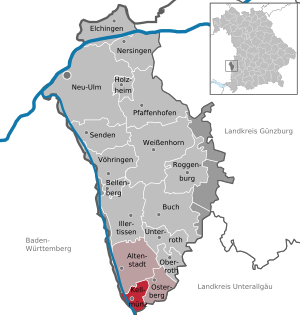
| Location of the Kellmünz adIller market in the Neu-Ulm district | ||
  |
||

Kellmünz an der Iller (officially Kellmünz adIller ) is a market in the Swabian district of Neu-Ulm and a member of the Altenstadt administrative community .
geography
The market is located in Upper Swabia on the Iller , about halfway between Illertissen and Memmingen .
history
Early history
Among the many settlements in and on the edge of the Illertal valley, Kellmünz stands out due to its unusual name. It points to a pre-Germanic past. The name is derived from Caelius Mons , in German Himmelsberg. In the year 15 BC The Romans occupied the land between the Alps and the Danube and established the province of Raetia . The legionaries probably formed an originally Celtic place name, developed as * Kalamantia , to caelius mons , presumably based on one of the seven hills of Rome called Caelius . Surely there was also a sanctuary on the mountain. After the fall of the Limes by the Alemanni, the Romans changed the strategy to secure the Alpine foothills. Instead of a solid border wall, they built forts in the hinterland. One of the most important was built around 300 AD on the Caelius Mons. It was enclosed by a mighty stone wall in the square, 100 m long and 100 m wide, with many towers. The fort housed around 300 men. Where the church stands today, there was a similarly large hall with an apse and portico. However, the Roman building faced south, while the church faced east. The representative Roman auditorium was probably used for administration, justice and cult.
Kellmünz Castle belonged to the Count Palatine of Tübingen until the death of Count Palatine Gottfried I on January 30, 1316. Gottfried I had a daughter named Agnes , who was married to Ulrich von Rechberg the Elder and who received Kellmünz as a paternal inheritance.
Second World War
Towards the end of the war on April 25, 1945, the Iller Bridge was blown up by the Wehrmacht to prevent the advancing Allies from crossing to Bavaria. As a result, there were two days of fighting over the blown bridge. Tanks of the American land forces shot the village on fire. Thirty-three properties were destroyed in the process.
Population development
Between 1988 and 2019 the market grew from 1,180 to 1,421 by 241 inhabitants or 20.4%.
politics
Municipal council
The municipal council has twelve members. As in the 2014 to 2020 term of office, all mandates will be held by the Kellmünz voter community . (Status: local election on March 15, 2020)
mayor
In 2002 Wolfgang Huber was elected mayor and was confirmed in office in 2008. Michael Obst (* 1970) has been the mayor since May 2014; he was elected in March 2014. In the local election on March 15, 2020, he was confirmed in office for a further six years with 83.3% of the vote.
coat of arms
The coat of arms description reads: In gold above a blue armored red lion growing from the lower edge of the shield, a three-lobed red storm flag with three silver rings.
Attractions
- Traces of the Thirty Years War
- Roman Catholic Parish Church of St. Martin
Soil monuments
See: List of ground monuments in Kellmünz an der Iller
- Roman fort Caelius Mons
traffic
Kellmünz station is on the Neu-Ulm – Kempten railway line . The Kellmünz – Babenhausen railway branched off here in the past . The state road St 2031 crosses the village. From there the state road St 1264 branches off to Dettingen . About 1.5 km to the west, on the opposite side of the Iller, runs the A 7 motorway with the Altenstadt (AS 125) and Dettingen ad Iller (AS 126) junctions .
On May 18, 1971, several coaches of the Oberstdorf-Dortmund express train derailed at the Kellmünz station exit in the direction of Ulm at a speed of approx. 130 km / h due to a track warping. 5 travelers lost their lives, 46 others were injured. The track warping was due to track construction work that was not carried out properly.
Web links
- Entry on the coat of arms of Kellmünz an der Iller in the database of the House of Bavarian History
Individual evidence
- ↑ "Data 2" sheet, Statistical Report A1200C 202041 Population of the municipalities, districts and administrative districts 1st quarter 2020 (population based on the 2011 census) ( help ).
- ^ Johann Daniel Georg von Memminger: Description of the Oberamt Biberach: With a map of the Oberamt, a view of Biberach and four tables. Cotta, 1837, page 173 of 211 pages
- ↑ Population figures in the Neu-Ulm district
- ↑ Fruit elected: Smooth transition in Kellmünz - Michael Obst becomes the new mayor of the community of Kellmünz. 17th March 2014.
- ↑ Hans-Joachim Ritzau: Disasters of the Deutsche Bahn - Part 1, p. 139 ff.

Altenstadt | Bellenberg | Book | Elchingen | Holzheim | Illertissen | Kellmünz on the Iller | Nersingen | Neu-Ulm | Oberroth | Osterberg | Pfaffenhofen an der Roth | Roggenburg | Send | Unterroth | Voehringen | Weissenhorn
Unregulated areas: Auwald | Oberroggenburg Forest | Stoffenrieder Forest | Unterroggenburg Forest