Steindorf (Swabia)
| coat of arms | Germany map | |
|---|---|---|

|
Coordinates: 48 ° 13 ' N , 11 ° 0' E |
|
| Basic data | ||
| State : | Bavaria | |
| Administrative region : | Swabia | |
| County : | Aichach-Friedberg | |
| Management Community : | Mering | |
| Height : | 538 m above sea level NHN | |
| Area : | 16.2 km 2 | |
| Residents: | 976 (Dec. 31, 2019) | |
| Population density : | 60 inhabitants per km 2 | |
| Postal code : | 82297 | |
| Area code : | 08202 | |
| License plate : | AIC, FDB | |
| Community key : | 09 7 71 168 | |
| Community structure: | 5 parts of the community | |
| Association administration address: | Kirchplatz 4 86415 Mering |
|
| Website : | ||
| Mayor : | Paul Wecker ( community of voters ) | |
| Location of the municipality of Steindorf in the Aichach-Friedberg district | ||
Steindorf is a community on the south-eastern edge of the Swabian district of Aichach-Friedberg and a member of the Mering administrative community .
geography
location
The place is about 20 kilometers southeast of Augsburg .
Community structure
The municipality has five officially named municipal parts (the type of settlement is given in brackets ):
- Eresried ( parish village )
- Hausen near Hofhegnenberg ( Kirchdorf )
- Hofhegnenberg ( village )
- Cleaning mill ( wasteland )
- Steindorf (parish village)
history
Until the church is planted
Steindorf belonged to Count Dux von Hegnenberg. The place was part of the closed Hofmark Hofhegnenberg of the Electorate of Bavaria . With the second municipal edict of 1818, the municipality of Steindorf came into being.
Incorporations
Before the municipal reorganization of Bavaria , the community belonged to the Fürstenfeldbruck district . On July 1, 1972, she moved to the Aichach-Friedberg district. The previously independent municipalities Eresried, Hausen bei Hofhegnenberg and Hofhegnenberg were incorporated into Steindorf on May 1, 1978.
Population development
Between 1988 and 2019 the municipality grew from 788 to 976 by 188 inhabitants or 23.9%.
politics
Municipal council
The 2008 local elections resulted in the following distribution of seats in the local council:
- Voting community Steindorf, Hausen, Eresried : 5 seats
- Hofhegnenberg Free Voting Association: 3 seats
The 2014 and 2020 local elections did not result in any change in the distribution of seats.
Mayor has been Paul Wecker since May 2002; he was last confirmed in office on March 15, 2020 for a further six years.
coat of arms
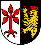
The description of the coat of arms reads: split of silver and black, in front a red beech with four roots, behind a red crowned and reinforced golden lion's trunk .
Attractions
The four-winged Hofhegnenberg Palace and the baroque parish church of St. Stephan in Steindorf are among the most important buildings in the community .
Architectural monuments
Soil monuments
See: List of soil monuments in Steindorf (Swabia)
traffic
Street
The district road AIC 18 leads through the village of Steindorf and joins the state road 2052 in the west of the municipality . Bundesstraße 2 runs just north of the municipality .
bus
A bus line operated by DB Regio Bus Bayern GmbH (DRB) connects Steindorf with Mering .
train
The single-track Ammerseebahn has been running west of Steindorf since June 30, 1898 from Mering via Geltendorf to Weilheim . It is managed by Deutsche Bahn as the route book route 985. On the Ammerseebahn, in the middle between Steindorf and the neighboring community of Schmiechen, there is the Schmiechen (Schwab) train station , which is only a stop today. The station is served every hour by the trains of the Bayerische Regiobahn (BRB) from Augsburg-Oberhausen to Schongau . In the rush hour , individual amplifier trains run between Augsburg and Geltendorf.
Web links
- Steindorf (Swabia) in the location database of the Bayerische Landesbibliothek Online . Bavarian State Library
- Entry on the coat of arms of Steindorf (Swabia) in the database of the House of Bavarian History
Individual evidence
- ↑ "Data 2" sheet, Statistical Report A1200C 202041 Population of the municipalities, districts and administrative districts 1st quarter 2020 (population based on the 2011 census) ( help ).
- ^ Community Steindorf in the local database of the Bavarian State Library Online . Bavarian State Library, accessed on August 20, 2019.
- ^ Federal Statistical Office (ed.): Historical municipality directory for the Federal Republic of Germany. Name, border and key number changes in municipalities, counties and administrative districts from May 27, 1970 to December 31, 1982 . W. Kohlhammer, Stuttgart / Mainz 1983, ISBN 3-17-003263-1 , p. 788 .
- ^ Andreas Janikowski: The Ammerseebahn. Traffic development in western Upper Bavaria . Transpress, Stuttgart 1996, ISBN 3-344-71033-8 , pp. 39 .
- ↑ Description of the Schmiechen train station ( Memento of the original from July 19, 2013 in the Internet Archive ) Info: The archive link has been inserted automatically and has not yet been checked. Please check the original and archive link according to the instructions and then remove this notice. on Ammerseebahn.de


