
Maisach (Amper)
| Maisach | ||
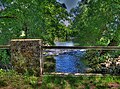
 The Maisach near Maisach, approx. 14 km away. |
||
| Data | ||
| Water code | EN : 1644 | |
| location | Upper Bavaria | |
| River system | Danube | |
| Drain over | Amper → Isar → Danube → Black Sea | |
| source | in Moore Weis -Hohenzell 48 ° 7 '32 " N , 11 ° 3' 55" O |
|
| Source height | approx. 590 m | |
| muzzle | near Dachau- Mitterndorf in the Amper coordinates: 48 ° 15 ′ 10 ″ N , 11 ° 24 ′ 50 ″ E 48 ° 15 ′ 10 ″ N , 11 ° 24 ′ 50 ″ E |
|
| Mouth height | 482 m | |
| Height difference | approx. 108 m | |
| Bottom slope | approx. 3 ‰ | |
| length | 36 km | |
| Catchment area | 204 km² | |
| Discharge at the Bergkirchen A Eo gauge: 204.17 km². Location: 4.3 km above the mouth |
NNQ MNQ 1936/2007 MQ 1936/2007 Mq 1936/2007 MHQ 1936/2007 HHQ (05/30/1940) |
250 l / s 944 l / s 1.99 m³ / s 9.7 l / (s km²) 17 m³ / s 44.7 m³ / s |
The Maisach is about 36 kilometers long, left tributary of the Amper in Bavaria , Germany . It runs in the Upper Bavarian districts of Fürstenfeldbruck and Dachau and is the namesake of the Maisach municipality in Upper Bavaria.
course
Its source is located south of Hohenzell (district of Moorenweis ) on the road to Türkenfeld . It first flows north and brushes against Moorenweis and Grunertshofen . At Mammendorf it bends to the east and runs past Maisach , flows through Überacker and passes Bergkirchen . At Dachau it flows into the Amper .
Tributaries
Due to the inflow of the Moosgraben near Albertshofen , the Maisach loses the width of a meadow ditch. Its largest tributary is the Erlbach from the Wildmoos near Jesenwang , which flows into the Maisach near Mammendorf . Further tributaries are the Bussbach and Weiherbach, Lappach and Rottbach near Überacker to the west of Mammendorf.
Origin of name
Maisach, first mentioned in 853 as Meisaha , is made up of the Old High German aha 'water, watercourse, river' and meisa ' titmouse ' and therefore means something like titmouse .
fauna
Since 2004 the beaver has resettled on the river. Browsing marks, as are typical for beavers, appeared as early as 1990 above the Wecker sawmill in Mammendorf.

Shortly after the source. Hohenzell, Flkm approx. 36.

Rare: in the forest. Albertshofen, Flkm approx. 32.

Typical: straightened in fields and corridors. Near Grunertshofen, Flkm approx. 27.
At Bergkirchen, approx. 4.5 km. ⊙

Alluvial forest-like and diked: just before the confluence with the Amper. Dachau, Flkm approx. 0.1.


literature
- Paul-Eckard Salzmann: Geology and Geography. In: Hejo Busley, Toni Drexler, Carl A. Hoffmann, Paul-E. Salzmann, Klaus Wollenberg: Fürstenfeldbruck district. Nature - history - culture. 1992, ISBN 3980318907 , p. 31
Web links
Individual evidence
- ↑ Bavarian State Office for the Environment Ref. 88 Flood News Center ( Memento of the original from September 5, 2007 in the Internet Archive ) Info: The archive link has been inserted automatically and has not yet been checked. Please check the original and archive link according to the instructions and then remove this notice.
- ↑ Wolf-Armin Frhr. v. Reitzenstein : Lexicon of Bavarian place names. Origin and meaning . CH Beck, Munich 2006, ISBN 3-406-55206-4 , p. 158 .