
Administrative community at the Brahmetal
| coat of arms | Germany map | |
|---|---|---|

|
Coordinates: 50 ° 54 ' N , 12 ° 12' E |
|
| Basic data | ||
| Existing period: | 1991– | |
| State : | Thuringia | |
| County : | Greiz | |
| Area : | 51.79 km 2 | |
| Residents: | 4512 (Dec. 31, 2019) | |
| Population density : | 87 inhabitants per km 2 | |
| License plate : | GRZ, ZR | |
| Association key : | 16 0 76 5008 | |
| Association structure: | 8 municipalities | |
| Association administration address : |
Dorfstrasse 17 07580 Grossenstein |
|
| Website : | ||
| Chair : | Sabine Barth | |
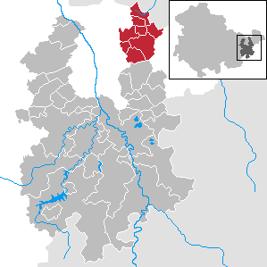
| Location of the administrative community Am Brahmetal in the district of Greiz | ||
  |
||


In the administrative community Am Brahmetal in the Thuringian district of Greiz , eight communities have come together to handle their administrative business. The administrative association is based in Großenstein.
The municipalities
The number of inhabitants in brackets (as of December 31, 2019):
- Bethenhausen (222)
- Brahmenau (917)
- Grossenstein (1201)
- Hirschfeld (113)
- Basket feet (432)
- Pölzig (1164)
- Reichstädt (332)
- Schwaara (131)
Data source: Thuringian State Office for Statistics
history
The administrative community was founded on May 2, 1991 under the name Oberes Sprottetal . Members at that time were the communities of Großenstein and Reichstädt. On February 3, 1995, when the administrative community of Upper Sprottetal was renamed Am Brahmetal , the remaining municipalities that had been independent up to that point joined.
Population development
Development of the population (as of December 31st) :
|
|
|
|
|
- Data source: Thuringian State Office for Statistics
Individual evidence
- ^ Population of the municipalities from the Thuringian State Office for Statistics ( help on this ).
existing: Am Brahmetal | Münchenbernsdorf | Wish village / Elster
former: Auma | Auma-Weidatal | Erlbach-Stübnitzthal | Harth | Leubatal | Neumühle / Elster | Drive | Vogtland Oberland | Weidatal