Helmegau
The Helmegau even Helmungowe called, was a medieval Gaugrafschaft on the southeastern edge of the Central Mountains resin .
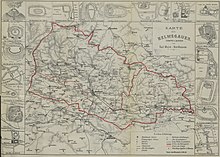
It covers roughly the upper catchment area of the Helme , west of the Sachsengraben, i.e. above Martinsrieth near Sangerhausen . According to the map, the Helmegau between Martinsrieth and around Voigtstedt only includes the southwestern half (to the right of the then swampy, impassable Helmeried), including the catchment area of the Wolwedabaches- Kleine Helme. The left northeast half of this part of the catchment area below Martinsrieth belonged to the Friesenfeld ("Frisonovel"), which completely encloses the catchment areas of the helm tributaries Gonna and Rohne and extends to the northern bank of the Unstrut below Kalbsrieth .
Another Gau of the Golden Aue is the Nabelgau , which encompasses the entire catchment area of the left Unstrut bank between the Unstrut breakthrough of the Hainleite ( Thuringian Gate ) near Sachsenburg to between Artern and Ritteburg , i.e. the "Esperstädter Wiesen" including the entire catchment area of the Kleine Wipper ( Bad Frankenhausen ) with its tributaries Badraer Bach - Thaleber Bach and Rodegraben-Siedebach ( Bendeleben ), including the Kyffhäuserbach near Ichstedt and Borxleben .
It is not possible to precisely limit all of these areas, as the area limits often only existed for a short period of time. Furthermore, there is a lack of historical evidence.
The last-mentioned article also reports on a Zorgegau , which covered a large part of the upper Helme catchment area; especially the tributaries that lead from the Harz to the floodplain, such as the Zorge (including Wieda , Uffe (Sachsengraben) and Bere ) and Ichte (including Steina ), and thus restrict the Helmegau to the then still marshy lowlands of the Goldenen Aue . This Zorgegau is not recorded in the above map, but part of the entire Helmegau catchment area.
The catchment area of the Helme and the Helemegau includes the Harz rivers Steina, Ichte, Uffe, Sachsengraben (Bad Sachsa), Wieda, Zorge, Bere (Zorge), Thyra , Krebsbach , Haselbach and Nase, Leine (Bennungen), in addition to the Helme The upper catchment area of the Bennener Leine (above the large lines) is attributable to the Friesenfeld.
From the south side of the Golden Aue, i.e. north of the Windleite and the Kyffhäuser Mountains , there are few Helme tributaries, one of these few tributaries is the Wolweda , also known as Walweda or Pfüffeler Bach . This flowing water has its source in the Kyffhäuser Mountains and flows through Tilleda. Finally at Hackpfüffel it flows into the little helmets , a branch of the helmets.
To the west and south-western edge of the Goldene Aue, the following noteworthy rivers flow into the Helme:
- Ohe (flows through Epschenrode , mouth at Schiedungen )
- Bliedebach (flows through Friedrichsthal , confluence between Schiedungen and Pützlingen )
- Haferbach (flows through Immenrode , brushes against oats , mouth at the Flarichsmühle )
- Röstegraben (flows through major changes , mouth with small changes )
- Riedgraben (also Schatebach , flows through the Schate , brushes against stone bridges , estuary near Uthleben )
- Zorge (mouth near herring)
- Goldbornbach (mouth near Heringen / Helme )
- Hammaer Bach, over Flutgraben (flows through Hamma, mouth Aumühle )
- Sole (flows through Kelbra ), together with the Siechengraben (flows through Sittendorf ; estuary between Thürungen and Kelbra)
Neighboring and near Gaue des Helmegau were: Harzgau (north), Friesenfeld and Hassegau (both in the east), Nabelgau (south-east), Altgau (south), Wippergau (south-west) and Liesgau (west).
history
The Helmegau was mentioned in writing in 802 in a certificate from Charlemagne, in which the Hersfeld Abbey was awarded 2 goods, one of them in the Helmegau.
Zorgegau
In 927 Woffleben and Gundersleben are mentioned in the Zorgegau.
literature
- Karl Meyer, Richard Rackwitz: Der Helmegau , in the Mitheilungen of the geography association in Halle / Saale part 1 (1888) pages 42ff and part 2 (1889) pages 101ff
- Karl Meyer, Richard Rackwitz, Vincent Eisfeld (ed.): The Helmegau. Prehistory and early history of the landscape surrounding Nordhausen; Part 1. (= sources and representations on the history of the city of Nordhausen; Vol. 2 ) Epubli, Berlin 2019. ISBN 978-3-7485-0384-2
- Hans Silberborth : History of the Helmegau . Hornickel, Nordhausen 1940.
See also
Individual evidence
- ↑ (see map "The Medieval Gaue around 1000")
- ↑ Bernd Sternal: The Harz story. Early and High Middle Ages , Verlag Sternal Media 2012, Die Gaugrafschaften des Harzgebietes, pages 33–35
- ↑ Martin Beitz: Exploratory trips into the Friesenfeld . Part 3 2011 am Sachsengraben ( Memento of the original from March 25, 2016 in the Internet Archive ) Info: The archive link was inserted automatically and has not yet been checked. Please check the original and archive link according to the instructions and then remove this notice.
- ↑ August von Wersebe: Description of the district between the Elbe, Saale and Unstrut, Weser and Werra. Published by Hahn'schen Buchhandlung, Hanover 1829, pages 59
- ↑ RI II, 1 n. 17, in: Regesta Imperii Online, URI: [1] (accessed on August 22, 2017)


