
Badra Bach
| Badra Bach | ||
 The Badraer Bach in Steinthaleben, also Thaleber Bach called |
||
| Data | ||
| location | Thuringia , Germany | |
| River system | Elbe | |
| Drain over | Unstrut → Saale → Elbe → North Sea | |
| source | several at Badra 51 ° 29 '17 " N , 10 ° 38' 49" E |
|
| muzzle | In the Unstrut as a flood ditch near Artern / Unstrut
|
|
| length | approx. 27 km | |
| Small towns | Bad Frankenhausen / Kyffhäuser | |
| Communities | Kyffhäuserland | |
The Badraer Bach sometimes also Thaleber Bach , Thalebener Bach or Flutgraben rises from several sources southwest of Badra in the municipality of Kyffhäuserland in the Kyffhäuserkreis in Thuringia .
course
It rises from several sources southwest of Badra and flows mainly in a westerly to southwestern direction. It is also fed by a brook from the sailing pond in the Sondershausen city forest . The first place on its route is Badra. The second place further down the course is Steinthaleben . Below the village, not far from Rottleben , is the entrance to the Barbarossa Cave . Here the creek is crossed by the Kleine Wipper . The former Falken and Lohmühle are also located in this area. The only town on the river is Bad Frankenhausen . Before it flows into the Unstrut as a flood ditch near Artern , it touches Esperstedt .
photos
The pictures are arranged downstream.

The Badraer (Thaleber) brook in Steinthaleben at the municipal administration
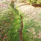
The Thaleber Bach below the Barbarossa Cave, upstream
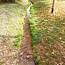
The Thaleber Bach below the Barbarossa Cave, downstream
_Bach.jpg)


Web links
Individual evidence
- ↑ Map from Google Earth