Steinthaleben
|
Steinthaleben
Community Kyffhäuserland
|
|
|---|---|
| Coordinates: 51 ° 23 ′ 41 ″ N , 11 ° 1 ′ 28 ″ E | |
| Height : | 170 m above sea level NN |
| Area : | 30.88 km² |
| Residents : | 473 (December 31, 2011) |
| Population density : | 15 inhabitants / km² |
| Incorporation : | December 31, 2012 |
| Postal code : | 99707 |
| Area code : | 034671 |
|
Location of the district in Kyffhäuserland
|
|
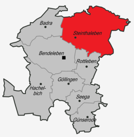
Steinthaleben is a municipality Kyffhäuserland in Thuringia Kyffhäuserkreis .
geography
The place Steinthaleben is on the Thallebener Bach , on the southwest edge of the Kyffhäuser Nature Park . The entire western part of this small, wooded low mountain range belongs to the territory of the municipality. About 518 hectares south and west of the village are used for agriculture. The highest elevation in the Steinthaleben district is the Kulpenberg at 473.4 m above sea level. NN.
There is a former gravel pit about one kilometer south of Steinthalebens. A small biotope has arisen here with many frogs, fish, insects and birds. In addition, a considerable population of bulrushes has developed here.
climate
Due to its location in the rain shadow of the Harz Mountains and the Kyffhäuser Mountains, Steinthaleben is one of the regions in Germany with the lowest rainfall. However, on April 26, 2006, a severe storm raged over the village and caused considerable damage from flooding.
history
Two prehistoric burial grounds provide important clues for the development of today's village of Steinthaleben. In the gravel pit on the southern outskirts, a grave from the Thuringian royal period (454-531) was recovered. The associated settlement is likely to be found in today's village location. The Imperial Castle Kyffhausen was built in the 11th century in what is now the Steinthalebens area . The Rathsfeld settlement ("the cleared field") was probably built during this time. However, in a sales deed from 1268, in which it was assigned to the Walkenried monastery , it was already described as a desert. Presumably the lack of water had forced the settlers to give up. It was not until 1698 that the Counts of Schwarzburg built a baroque hunting lodge on this site .
The first written mention of Steinthaleben comes from the year 1093, the year the Benedictine monastery Miminde was founded, later Bursfelde , near Dransfeld on the upper Weser . Archbishop Ruthard of Mainz certifies that a Count Heinrich with his wife Gertrud bequeathed the above re-establishment, along with many other possessions, also some goods to Berga, Dalheim ("valley settlement") and the mill at Kalvern ( Kelbra ) etc. In the letter of protection from Pope Innocent III. For the Walkenried monastery from 1205, a wine farm in Dalehn is confirmed to this place. Later the place appears in Walkenrieder documents as Thaleheim (1209), Dalehn (1211), Thalheim (1215) and even 1506 as Talheym . The original name for the village suggests a Franconian name. The place has only appeared as Thaleben (1525 Talleyben ) since the 16th century, and in the following centuries also as Steinthaleben , which, however, only became the official name in 1927.
Viticulture must have been in high bloom for a long time. Two wine masters from Steinthaleben are known by name: Johann von Bartholfelde (1345–1354) and Hans von Tullede (1390). The field names Weinberg, Mönchenberg and Keltertal still remind of this.
Since the 13th century, knights who named themselves after Thalheim appear especially in the series of witnesses in Beichling documents.
It is not known when the Reformation took place in Steinthaleben. The Walkenried monastery was probably anxious to keep its possessions in the village for as long as possible. In 1543 Abbot Paulus von Walkenried sold the monastery property and the associated woodwork, six Hufen land, sheep farm and bakery for 840 Florentine guilders to Count Günther von Schwarzburg ( Count of Schwarzburg ). Since it was not redeemed, the village remained in Schwarzburg's possession from that time. Steinthaleben became part of the subordination of the Principality of Schwarzburg-Rudolstadt . The Reformation may only have spread after the monastery ownership passed to Schwarzburg.
From a detailed report by the late, secret archivist Bangert, in the supplement to the Frankenhäuser Zeitung in May 1921, we learn interesting details about the high billing and contribution burdens and about the tough coercive measures that were used in the event of non-collection. From November 1631, Swedish troops also showed themselves to be subordinate. In November 1632, more than 50 Pappenheim riders came down from Thalleber Berg, overran the town of Kelbra and took it.
Copper slate mining began in the Kyffhäuser Mountains around the middle of the 16th century. Many heaps and pings in the area around the Rathsfeld and in the surrounding corridor testify that mining was carried out for centuries. But the yield was always very low.
The Barbarossa Cave owes its discovery in 1865 to a last attempt to mine the ores on a larger scale deeper in the interior of the mountains .
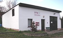
The Steinthaleben volunteer fire brigade was founded in 1868 . There is a separate house with a garage for the emergency vehicle.
The Kyffhäuser monument was erected in 1896. After the end of the First World War, the Free State of Schwarzburg-Rudolstadt was established at the end of November 1919 , and in 1920 it became part of the new state of Thuringia . During the GDR there was a pioneer holiday camp in Steinthaleben on the grounds of the Rathsfeld hunting lodge .
On December 31, 2012, the municipality of Steinthaleben merged with other municipalities of the Kyffhäuser community to form the municipality of Kyffhäuserland.
In addition to Steinthaleben, the places Rathsfeld and Kyffhausen belonged to the community.
Population development
Development of the population of the Steinthaleben community (December 31) :
|
|
|
Sponsorship of the Bundeswehr
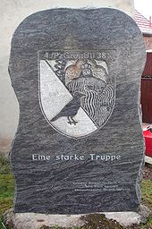
From June 8, 1993 to September 30, 2002 there was a sponsorship agreement between the 4th Company of Panzergrenadier Battalion 381 of the Bundeswehr and Steinthaleben. A memorial stone reminds of this time. The sponsorship ended with the dissolution of the armored infantry battalion. The stone itself was donated by a local master stonemason.
coat of arms
The coat of arms was approved on March 15, 1994.
Blazon : "Above a silver shield base, in it a red rafter, in blue on the right a left-looking lion divided nine times by red and silver and on the left a right-looking red-tongued and red-armored golden lion, both holding a golden diamond."
The rafter, which symbolizes the word valley, and the diamond as a symbol for stone stand as talking elements in the coat of arms. The golden lion is taken from the family coat of arms of the Counts of Schwarzburg, who had possessions in the community for a long time and were lords of Rothenburg and Kyffhausen Castle for centuries, both of which now belong to Steinthaleben. Based on the coat of arms of the Thuringian landgraves , the lion, divided eight times from red to silver, was included in the coat of arms. In 1272 the landgraves donated goods that are in today's parish corridor to the Walkenried monastery. They were also owners of Rothenburg and Kyffhausen Castle in the 14th century.
The coat of arms was designed by the heraldist Michael Zapfe .
Culture and sights
Buildings
The Reichsburg Kyffhausen is one of the largest castle complexes in Germany. Today there are still ruins of the lower castle. With a depth of 176 m, the Reichsburg Kyffhausen has the deepest castle well in the world. The 81 m high Kyffhauser monument , erected near the Reichsburg Kyffhausen between 1890 and 1896, shows the equestrian statue of Kaiser Wilhelm I and the figure of Barbarossa carved in stone .
In the Rathsfeld district is the Rathsfeld hunting lodge , which was built by Count Anton von Schwarzburg-Rudolstadt between 1697 and 1698 , although there was also a previous building on the site. The hunting lodge is a three-wing building with a corps de logis and has a living space and additional usable area of around 5000 m², 168 windows and 80 doors. During the time of the GDR it was used as a company holiday home for VEB Robotron Optima Büromaschinenwerk Erfurt and as a pioneer holiday camp. In 1998 it was sold by the Treuhandanstalt to a private owner who let the building fall into disrepair. Since 2006 it has been in ruins due to arson. In 2007 the building received the Black Sheep of the Thuringia Monument Association because of its neglect .
A double chapel also belongs to the castle . The baroque palace park is around 250,000 m², with only 56,000 m² being preserved in its original state.
The ruins of the Rothenburg are on the northern edge of the Kyffhäuser Mountains . The Kulpenberg television tower is also located on the Kyffhäuser .
The oldest building in the village is the old parish , built in the early 17th century. In 2008 the listed building was sold by the municipality to a private person. The village church, built in 1735, can be viewed by appointment.
The First World War brought painful losses. 40 out of 800 inhabitants fell victim to the war. In their honor a memorial was erected in the church garden on September 25, 1921. The Second World War claims even greater victims. 46 men are killed, 26 are missing. Her memory was recorded on a wooden plaque on the north wall of the church. Later your names were also engraved on the war memorial. The monument is made of sandstone and showed the usual signs of weathering with this material. In 2008 it was completely renovated.
Natural monuments
In Steinthaleben there is one of the largest linden trees in Thuringia at the entrance to the old cemetery, the twin linden trees. The larger of the two trees has a trunk circumference of 4.88 m at a height of 1.3 m. The tree is about 22 m high. In the village there are still several old sandstone walls on which many plants grow. So-called joint plants as well as moss and lichen species have settled on the sandstones or in the cracks.
sport and freetime
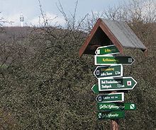
There are a number of well-marked hiking trails around Steinthaleben. Due to the consistently quite dry climate in the rain shadow of the Kyffhäuser Mountains, all trails can be easily walked all year round. Most of the routes lead through the Kyffhäuser Nature Park with its diverse flora and fauna. Many rare wildflowers can be found along the way. The hiking trails are often very original and narrow. Occasionally you have to work your way through narrow ravines.
Each year, the are Kyffhaeuser mountain running , as well as on the curved road from the Förster house up to the Kulpenberg ( Kyffhaeuser race track ), the ADAC -Kyffhäuser- Bergrennen discharged.
The old gravel pit and the Kelbra dam , located around five kilometers north of Steinthaleben, are ideal for swimming .
Regular events
- Sports Festival (May)
- Spring Festival (May)
- Rooster Crows (May)
- Maypole setting (May)
- Children's party (June)
- Fair (October)
- Poultry Show (November)
- Traditional and Easter bonfires (October, Easter)
societies
- Football club FC Kyffhäuser Steinthaleben
- Pedigree Poultry Breeding Association
- Garden club
- Antenna association (community antenna & "village canal")
- Riding, breeding and driving association Friesenfreunde Kyffhäuser
- Kirmesburschen Steinthaleben eV
- Fossil Minerals Mining Association
- History association
Partner municipality
Flein in the district of Heilbronn in Baden-Wuerttemberg since June 1991. In memory of the sponsorship, the Flein linden tree was planted in the village .
gallery
Web links
Individual evidence
- ↑ StBA: Area changes from January 1st to December 31st, 2012
- ^ New Thuringian Wappenbuch Volume 2, page 30; Publisher: Arbeitsgemeinschaft Thüringen eV 1998 ISBN 3-9804487-2-X


