Günserode
|
Günserode
Community Kyffhäuserland
|
|
|---|---|
| Coordinates: 51 ° 18 '28 " N , 11 ° 2' 57" E | |
| Height : | 180 m above sea level NN |
| Area : | 8.52 km² |
| Residents : | 164 (December 31, 2011) |
| Population density : | 19 inhabitants / km² |
| Incorporation : | December 31, 2012 |
| Postal code : | 99707 |
| Area code : | 034671 |
|
Location of Günserode in Kyffhäuserland
|
|
|
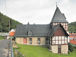
Church in Günserode (2014)
|
|
Günserode is a municipality Kyffhäuserland in Thuringia Kyffhäuserkreis .
geography
Günserode is a street village and is located southeast of the Wipper breakthrough in the Wippertal.
View from the Arnsburg to the Wippertal
history
A hermit named Günther is mentioned in the year 1006 , who gave the village to the Benedictine monastery in Göllingen . The name of the hermit could be the etymological origin of today's place name: Günserode = "clearing of Günther".
In 1265 the place came to the monastery Kapelle , which was on the left bank of the Wipper between Günserode and Seega . In 1193 it became a Benedictine monastery and was closed again around 1537, probably as a result of the Reformation . Later, a chapel mill with an excursion restaurant was built here , of which only a ruin remains today.
The place had been owned by the House of Schwarzburg since 1356 and became part of the rule of the Principality of Schwarzburg-Rudolstadt . After the end of the First World War, the Free State of Schwarzburg-Rudolstadt was established at the end of November 1919, and it was incorporated into the State of Thuringia in 1920.
On December 31, 2012, the community of Günserode merged with other communities of the Kyffhäuser community to form the community "Kyffhäuserland".
Population development
Development of the population of the community of Günserode (December 31) :
|
|
|
- Data source: Thuringian State Office for Statistics
politics
In the state elections in 2009 , Die Linke achieved its best result nationwide with 47.5% of the second vote.
Culture and sights
- On the Kohnstein (not to be confused with the Kohnstein in the southern Harz) there is a large, three-part rampart that dates from the late Bronze Age and the pre-Roman Iron Age . It is said to have been used in the Middle Ages. A rich bronze find was discovered and recovered from the Bronze Age. It is believed that this mountain was also a former cult site . The Kohnstein is popularly known as the Schwedenschanze .
- The Evangelical Church of St. Nicholas is originally a medieval building, of which the square choir tower has been preserved. The nave was renewed at the end of the 17th century. The tower has a hipped roof with a picturesque clock bay . Inside the complex has a three-sided, two-storey gallery , a wooden barrel and a baroque pulpit altar . The choir contains a groin vault . Above the triumphal arch is a mural from the early 20th century showing the Sermon on the Mount . The funnel-like baptismal font is from 1567.
- The parish belongs to the Evangelical Parish Office Bad Frankenhausen II.
- In Günserode there are historical and well-preserved half-timbered farms , u. a. Dreiseithöfe . Occasionally the buildings have gaff heads .
- In the vicinity of the village is the Wipper Breakthrough nature reserve , where thousands of orchids bloom in spring.
societies
- Hometown club
- Hunting association
- Allotment Association
Individual evidence
- ↑ StBA: Area changes from January 1st to December 31st, 2012
- ↑ Michael Köhler: Pagan sanctuaries . Jenzig-Verlag 2007, ISBN 978-3-910141-85-8 , p. 190
- ^ Dehio, Georg , edited by Stephanie Eißling, Franz Jäger and other specialist colleagues: Handbuch der deutschen Kunstdenkmäler, Thuringia . Deutscher Kunstverlag , 2003, ISBN 3-422-03095-6 , p. 550


