Hachelbich
|
Hachelbich
Community Kyffhäuserland
|
|
|---|---|
| Coordinates: 51 ° 20 ′ 39 ″ N , 10 ° 57 ′ 53 ″ E | |
| Height : | 190 m above sea level NN |
| Area : | 23.68 km² |
| Residents : | 614 (December 31, 2014) |
| Population density : | 26 inhabitants / km² |
| Incorporation : | December 31, 2012 |
| Postal code : | 99707 |
| Area code : | 03632 |
|
Location of the district in Kyffhäuserland
|
|
|
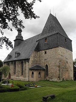
St. Petrus Church in Hachelbich (2014)
|
|
Hachelbich is a district of the community Kyffhäuserland in the Thuringian Kyffhäuserkreis .
geography
Hachelbich is located on the northern slope of the Hainleite in the Wipper valley , between the district town of Sondershausen in the west and Bad Frankenhausen in the east. The Windleite is located in the north of Hachelbich .
history
The fertile Wipper area has always been a favorable area for settlement. Archaeological excavations have revealed finds from various epochs. For example, pottery shards from the time of the corded ceramics (2800 to 2200 BC) or 8 kilns and a red and black painted vessel from the early Iron Age (800 to 600 BC). In 2010, during excavations north of the village, the remains of a Roman march from the 1st to 3rd centuries were discovered. The finds were made public in 2014.
The place was founded between the 6th and 9th centuries. Hachelbich was first mentioned in a document in 1186, when the Göllingen monastery acquired the fiefs of the Hersfeld ministerial Folbert in Göllingen and Hachelbich. From the outwork of the monastery a free courtyard was created with extensive land, from which the village could develop. From 1243 the Göllingen monastery and thus all of its possessions were under the patronage of Heinrich von Heldrungen . In 1356 the monastery again went to Count Heinrich XII. and Günther XXV. of the House of Schwarzburg . In 1539 Günter XL., Count of Schwarzburg-Sondershausen , introduced the Lutheran faith. During the Thirty Years' War the village was destroyed by Swedish horsemen in 1630 and 1631. In 1648 the Hersfeld Abbey with the Göllingen Monastery became a secular principality and an imperial fief when the peace agreement in Osnabrück . This made it subordinate to the House of Hessen-Kassel. In 1728, 1752 and 1757 some parts of the village fell victim to fires. In 1763 the Prussian military was quartered in the village buildings. In 1806, French soldiers looted the village during the battle of Jena and Auerstedt . After the abbey of Hersfeld was dissolved in 1810, Hachelbich became part of Kurhessen. 1816 finally bought Prince Günther Friedrich Karl I . the Vorwerk Hachelbich and so the place became part of the principality of Schwarzburg-Sondershausen ( subordinate rule ). After the end of the First World War , in which 106 men from Hachelbich took part, the Free State of Schwarzburg-Sondershausen was established at the end of November 1919 , and in 1920 it became part of the new state of Thuringia .
From 1938 to 1945 there was an ammunition production facility in Shaft IV that was cleared out by the Red Army .
On December 31, 2012, the municipality of Hachelbich merged with other municipalities of the Kyffhäuser community to form the municipality of Kyffhäuserland. In the same year, the bypass road is rebuilt.
Population development
Development of the population of the municipality of Hachelbich (December 31) :
|
|
|
- Data source: Thuringian State Office for Statistics
coat of arms
Blazon : “Split and divided in front; Above in red a silver trefoil cross, behind in silver a rooted red beech, below in blue a slanting silver fish. "
Hachelbich property also belonged to the Göllingen monastery . The monastery was founded in 992. The silver clover-leaf cross is intended to commemorate the chapel built in 1193. A unique phenomenon of the Hainleite is the copper beech , which grew spontaneously around 1680. It is shown stylized in the 2nd field. The fish is intended to indicate Hachelbich's natural conditions for fish farming and the color of the water. Due to belonging to the Principality of Schwarzburg-Sondershausen , fish were delivered to the Fürstenhof.
Culture and sights
- The Protestant parish church of St. Peter is located on a steep hill.
- The Marienbrunnen is located in the forest south of Hachelbich.
- In the vicinity of Hachelbich there are the nature reserves Filsberg - Großes Loh (No. 318, southwest), Gatterberge (No. 317, north) and Kahler Berg - Kuhberg (No. 319, southeast).
- The former forest swimming pool is to become a natural body of water.
Personalities
- Werner Schubert-Deister (1921–1991), painter and sculptor
Individual evidence
- ↑ Thüringer Allgemeine from May 10, 2014, cultural page: Archaeologists discover a Roman camp in Thuringia for the first time.
- ^ Council of the community of Hachelbich (ed.): 800 years Hachelbich . VEB service company, Sondershausen 1986, p. 48 .
- ↑ Dr. Wilfried Neumerkel: Of castles, monasteries and steppe plants . Ed .: Municipality of Kyffhäuserland and Dr. Wilfried Neumerkel. Kyffhäuserland May 2015, p. 120 .
- ↑ StBA: Area changes from January 1st to December 31st, 2012
- ^ New Thuringian Wappenbuch Volume 2, page 26; Publisher: Arbeitsgemeinschaft Thüringen eV 1998 ISBN 3-9804487-2-X
- ↑ Ingolf Gläser: Natural waters instead of an outdoor pool in Hachelbich . In: Thüringer Allgemeine , April 26, 2012. Accessed November 2, 2012.


