
Wieda (river)
| Again | ||
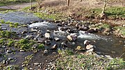
 The Wieda in the village of Wieda |
||
| Data | ||
| Water code | DE : 564822 | |
| location | Districts of Göttingen in Lower Saxony and Nordhausen in Thuringia ( Germany ) | |
| River system | Elbe | |
| Drain over | Zorge → Helme → Unstrut → Saale → Elbe → North Sea | |
| source | in the Harz at the Stöberhai 51 ° 39 ′ 43 ″ N , 10 ° 33 ′ 24 ″ E |
|
| Source height | approx. 545 m above sea level NHN | |
| muzzle | near Woffleben in the Zorge Coordinates: 51 ° 33 ′ 6 " N , 10 ° 44 ′ 25" E 51 ° 33 ′ 6 " N , 10 ° 44 ′ 25" E |
|
| Mouth height | 206.9 m above sea level NHN | |
| Height difference | approx. 338.1 m | |
| Bottom slope | approx. 15 ‰ | |
| length | 22 km | |
| Left tributaries | see below | |
| Right tributaries | see below | |
| often seepage in the southern Harz Zechstein belt | ||
The Wieda in the Lower Saxony district of Göttingen and the district of Nordhausen in Thuringia is an approximately 22 km long, western and orographically right tributary of the Zorge in the Harz and in the southern Harz Zechstein belt (southern Harz Zechstein hill) .
course


The Wieda rises in the Lower Saxony part of the Harz Mountains in the Harz Nature Park . Its origin lies north of the Stöberhai (approx. 720 m above sea level ) in the west of the Altes Loch valley : there, a little above a path point at 540.6 m , two short source streams converge at a height of about 545 m , which are on the high elevations of the mountain and run through the Öhren and Franzosental valleys . According to other sources, the source of the river is "north of the mountain Stöberhai" at an altitude of about 580 m .
Initially, the Wieda flows a little northeast and then southeast to the former Stöberhai station , just below it in the Steigertal to meet the state road 601. From then on, striving south, it passes the Stöberhai in the east and the Wiedaer Jagdkopf ( 602.1 m ) in the west, and shortly afterwards when passing the cheese mountain (approx. 520 m ) and the Knickings (approx. 505 m ) to the east and the Zorger to the west Jagdkopf ( 603.1 m ) to run through the village of Wieda . The Wieda then runs south-eastwards and leaves the Harz to flow from Walkenried into the southern Harz Zechstein hills. In doing so, she passes the Wiedigshof settlement .
The Wieda then changes over to Thuringia and from the Harz Nature Park to the Südharz Nature Park . Therein it flows directly south to Gudersleben and just north of Mauderode eastwards to slightly southern passing Woffleben to 206.9 m height in the coming also from the resin and there from northwest helmets influx Zorge to lead .
Water quality
In Thuringia, the Wieda is rated as "slightly polluted" ( water quality class I-II).
Infiltration
In the warm season, the Wieda often seeps into karst cavities in the gypsum karst landscape of the Südharzer Zechsteinhügel (Südharzer Zechsteinhügel) in order to continue to flow underground and to emerge elsewhere from karst springs and spring pots, such as the Salzaspring . In summers with little precipitation (hot) it happens that their riverbed dries up completely.
Tributaries
The tributaries of the Wieda include - viewed downstream and with orographic allocation :
- Breitenbach (left)
- Uffe ( Sachsengraben ; right)
- Valley ditch (right)
- Lochmühlengraben (left)
photos
The images are ordered downstream.

Wieda near Gudersleben
Wieda near Gudersleben

Wieda near Gudersleben


References and comments
- ↑ a b c Wieda origin on a topographical map with the Stöberhai-Nord region ( memento of the original from February 24, 2014 in the Internet Archive ) Info: The archive link was inserted automatically and has not yet been checked. Please check the original and archive link according to the instructions and then remove this notice. (DTK 25), on natur-erleben.niedersachsen.de
- ↑ a b mouth height according to unknown / not researched source
- ↑ a b c d e Die Wieda , on harzlife.de
- ↑ Water quality, flowing waters 2006 , on tlug-jena.de (PDF; 412.77 kB)