Hochstedter Bach
| Hochstedter Bach | ||
|
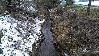
The Hochstedter Bach in February, not far from Hochstedt |
||
| Data | ||
| Water code | DE : 5648154 | |
| location | Nordhausen district , Thuringia, Germany | |
| River system | Elbe | |
| Drain over | Helme → Unstrut → Saale → Elbe → North Sea | |
| source | northeast of Steinsee | |
| Source height | approx. 289 m above sea level NN | |
| muzzle | in the helmets northwest of the Flarichsmühle Coordinates: 51 ° 30 ′ 15 ″ N , 10 ° 42 ′ 32 ″ E 51 ° 30 ′ 15 ″ N , 10 ° 42 ′ 32 ″ E |
|
| Mouth height | approx. 195 m above sea level NN | |
| Height difference | approx. 94 m | |
| Bottom slope | approx. 17 ‰ | |
| length | 5.6 km | |
| Medium-sized cities | Nordhausen OT Hochstedt | |
| Communities | Werther (lower course) | |
| Residents in the catchment area | 225 | |
|
Hochstedter Bach southwest of Hochstedt in January 2015, photographed upstream |
||
|
Hochstedter Bach southwest of Hochstedt in January 2015, photographed downstream |
||
The Hochstedter Bach is a left tributary of the Helme in the Nordhausen district , in Thuringia , in Germany . From the source to the mouth, the Hochstedter Bach is a second order body of water, the maintenance is the responsibility of the Harzvorland water maintenance association.
course
The Hochstedter Bach rises northeast of the hamlet of Steinsee . Before it reaches Hochstedt , it flows in a south-easterly direction. On the northern outskirts of Hochstedt, it bends in a south-westerly direction. Shortly before crossing under federal highway 243 , it reaches the area of the municipality of Werther and changes its direction of flow again. It flows south as far as the confluence with the Helme.


